Location
Latitude: |
41-36-37.0000N (41.610278) |
Longitude: |
090-35-18.1000W (-90.588361) |
Elevation: |
750.5 feet MSL (229 m MSL) |
Magnetic Variation: |
1.9 W (as of April 2024 from WMM2020 model) |
Time Zone: |
UTC -6.0 (Standard Time) UTC -5.0 (Daylight Savings Time) |
From City: |
05 N.M. N of Davenport, Iowa |
Found On: |
Chicago Chart |
FAA Region: |
ACE |
Contacts
Manager: |
Publicly owned: |
| THOMAS VESALGA PUBLIC WORKS 1200 EAST 46TH STREET DAVENPORT, IA 52807 563-326-7783 |
CITY OF DAVENPORT 9230 HARRISON STREET DAVENPORT, IA 52806 563-391-5650 |
Operations
Airport Status: |
Operational |
Facility Use: |
Public |
Type: |
Airport |
Activation Date: |
01/1950 |
Control tower: |
No |
Attendance (Months/Days/Hours): |
Months/Days/Hours ALL/ALL/0630-DUSK |
Boundary ARTCC: |
ZAU (Chicago) |
Responsible ARTCC: |
ZAU (Chicago) |
Lighting Schedule: |
SEE RMK |
Segmented Circle Indicator: |
No |
Traffic Pattern Altitude (MSL): |
1750 feet (533 m) |
NOTAMs Facility: |
DVN |
NOTAM-D Service: |
Yes |
International Airport of Entry: |
No |
Customs Landing Rights: |
No |
Military Landing Rights: |
Yes |
Civil/Military Joint Use: |
No |
Based Aircraft
| Single Engine: | 80 |
| Multi Engine: | 11 |
| Jet Engine: | 5 |
| Gliders: | 1 |
| Military Aircraft: | 12 |
Annual Operations (as of 04/18/2022)
| Total Operations: | 50850 | |
| Air Taxi: | 1831 | 3.6% |
| GA Local: | 21887 | 43.0% |
| GA Itinerant: | 26220 | 51.6% |
| Military Aircraft: | 912 | 1.8% |
Communications
| CTAF: | 123.000 |
| Unicom: | 123.000 |
| Clearance Del.: | 118.35 118.35 118.35 |
| Approach: | QUAD CITY CHICAGO ARTCC |
| Departure: | QUAD CITY CHICAGO ARTCC |
| ASOS: | 120.175 (563-388-2154) |
- APCH/DEP SVC PRVDD BY CHICAGO ARTCC ON FREQS 118.75/377.05 (MOLINE RCAG) WHEN QUAD CITY APCH CLSD.
Fixed Based Operators (FBOs) & Fuel
(Click on a business for detail)
Please help us keep this information up to date. This is a FREE SERVICE just like everything else on Airport Guide! If you see that a business needs to be added, modified, or deleted please fill out our Update Form.
To add, modify, or delete a business click here.
Please help us keep this information up to date. This is a FREE SERVICE just like everything else on Airport Guide! If you see that a business needs to be added, modified, or deleted please fill out our Update Form.
Area Code: 319 |
| Business Name | Frequency | Phone | Fuel Grade |
|---|---|---|---|
| Carver Aero, Inc.
Update FBO info |
Unicom 123.0 | 391-5650 | 100LL, Jet A |
Flight Service Stations
| Primary | Alternate | |
| FSS on Field: | N | |
| FSS Name (ID): | Fort Dodge(FOD) | |
| Frequency: | ||
| Toll Free Phone: | 1-800-WX-BRIEF |
Instrument Procedures / Charts
FAA Terminal Procedures valid from 0901Z 03/21/24 to 0901Z 04/18/24.
There are various types of charts available for an airport. They are listed in the Page Type column. Here is a legend for those types:
APD - Airport Diagram
DP - Departure Procedure Charts
HOT - Hot Spots
IAP - Instrument Approach Procedure Charts
MIN - Minimums
STAR - Standard Terminal Arrival Charts
| Page Type | Page Name | Volume | Action Since Last Cycle |
|---|---|---|---|
| APD | AIRPORT DIAGRAM | NC-3 | |
| IAP | ILS OR LOC RWY 15 | NC-3 | |
| IAP | RNAV (GPS) RWY 03 | NC-3 | |
| IAP | RNAV (GPS) RWY 15 | NC-3 | |
| IAP | RNAV (GPS) RWY 21 | NC-3 | |
| IAP | RNAV (GPS) RWY 33 | NC-3 | |
| IAP | VOR RWY 03 | NC-3 | |
| IAP | VOR RWY 21 | NC-3 | |
| MIN | ALTERNATE MINIMUMS | NC-3 | |
| MIN | TAKEOFF MINIMUMS | NC-3 |
Terminal Procedures are only available for airports in several countries with more being added all the time. If you are looking for a specific country's charts, please send an email to support(at)airportguide.com stating the country name. This will be used to prioritize the implementation.
Navigation Aids (Navaids) near DVN
| Dist (NM) | ID | Morse Code | Name | Type | Freq | True Hdg | Mag Hdg |
|---|---|---|---|---|---|---|---|
| 0.2 | DVN | _ . . . . . _ _ . | Davenport Municipal | VOT | 111.80 | 52 | 54 |
| 7.5 | CVA | _ . _ . . . . _ . _ | Davenport | VORTAC | 113.80 | 38 | 40 |
| 12.3 | FN | . . _ . _ . | Hillz | NDB | 517 | 46 | 48 |
| 17.5 | MZV | _ _ _ _ . . . . . _ | Moline | VOR-DME | 114.40 | 187 | 189 |
| 29.2 | DDD | _ . . _ . . _ . . | Port City | DME | 116.5 | 240 | 242 |
| 36.5 | BOZ | _ . . . _ _ _ _ _ . . | Whiteside | NDB | 254 | 80 | 82 |
| 41.0 | GBG | _ _ . _ . . . _ _ . | Galesburg | DME | 109.8 | 170 | 172 |
| 42.8 | DB | _ . . _ . . . | Zilom | NDB | 341 | 359 | 361 |
| 46.3 | IOW | . . _ _ _ . _ _ | Iowa City | VOR-DME | 116.20 | 263 | 265 |
| 47.8 | DBQ | _ . . _ . . . _ _ . _ | Dubuque | VORTAC | 115.80 | 353 | 355 |
| 52.2 | PLL | . _ _ . . _ . . . _ . . | Polo | VOR-DME | 111.20 | 65 | 67 |
| 52.5 | BDF | _ . . . _ . . . . _ . | Bradford | VORTAC | 114.70 | 120 | 122 |
| 52.7 | AWG | . _ . _ _ _ _ . | Washington | NDB | 219 | 248 | 249 |
| 55.3 | BRL | _ . . . . _ . . _ . . | Burlington | VOR-DME | 111.40 | 196 | 198 |
| 56.1 | CID | _ . _ . . . _ . . | Cedar Rapids | VOR-DME | 114.10 | 287 | 288 |
| 57.6 | MPZ | _ _ . _ _ . _ _ . . | Mount Pleasant | NDB | 212 | 226 | 228 |
| 62.2 | BR | _ . . . . _ . | Burns | NDB | 390 | 203 | 205 |
| 65.5 | JZY | . _ _ _ _ _ . . _ . _ _ | Macomb | NDB | 251 | 178 | 180 |
| 66.4 | PIA | . _ _ . . . . _ | Peoria | VORTAC | 115.20 | 146 | 148 |
| 66.8 | CTK | _ . _ . _ _ . _ | Canton | NDB | 236 | 159 | 161 |
Nearby Airports with Fuel
Notices to Airmen (NOTAMS)
Remarks
| A110-1 | HELICOPTER OPERATIONS ON CTAF OPERG PARALLEL TO RYS FM GRASS AREAS. |
| A110-10 | JET A AND 100LL FULL SVC AVBL ON MAIN RAMP IN FRONT OF TRML BUILDING. |
| A110-11 | 100LL SELF SVC FUEL AVBL ON E END OF TWY C. |
| A110-12 | FOR CD CTC CHICAGO ARTCC AT 630-906-8921. |
| A110-2 | RWY 15 DESIGNATED CALM WIND RY. |
| A110-3 | TWO WAY RADIO COMMUNICATIONS REQUIRED FOR ALL ACFT CONDUCTING MULTIPLE OPNS. |
| A110-4 | EXTSV HVY MIL HEL (CHINOOK) TRNG ON & INVOF OF ARPT; PSBL EXTREME TRUB FM ROTORS. |
| A110-7 | ARNG: DSN 431-5510. |
| A110-9 | PAEW ANG RAMP LIMITED PARKING 48 HR PPR. |
| A14 | JACOB SACHLEBEN , OPERATIONS MANAGER 563-391-5650 |
| A17 | FOR SVC AFT HRS CALL (563) 391-5650. |
| A81-APT | DUSK-DAWN. ACTVT MIRL RY 03/21 AND HIRL RY 15/33; VASI RYS 03/21 AND 15/33; MALSR RY 15 & REIL RWYS 3/21 AND 33 - CTAF. |
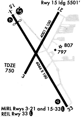
Runways
Runway Summary
| Runways: | 03/21 15/33 |
| Longest Runway: | 15/33 is 5511 ft (1680 m) long |
| Runways with an Instrument Approach: | 15 |
DVN Airport Runway Details
| Runway 03/21 | 4001 ft x 100 ft (1220 m x 30 m) | |
| Runway Length Source: | 3RD PARTY SURVEY as of 03/15/2012 | |
| Surface: | Concrete - Excellent condition - Saw-cut or plastic grooved | |
| Runway Pavement Class: | 29 /R/B/W/U | |
| Runway Edge Lights: | Medium Intensity | |
Runway Weight Bearing Capacity (in thousands of pounds) |
||
| Single Wheel Landing Gear: | 68.0 | |
| Dual Wheel Landing Gear: | 93.0 | |
| Dual Tandem Wheel Landing Gear: | 122.0 | |
Runway 03 |
Runway 21 |
|
Elevation: |
746.7 | 749.0 |
Latitude: |
41-36-26.8428N | 41-37-01.2205N |
Longitude: |
090-35-31.1975W | 090-35-05.2137W |
|
Runway True Alignment: |
030 | 210 |
Glide Path Angle: |
3.0 degrees | 3.0 degrees |
Traffic Pattern: |
Left | Left |
Runway Markings Type: |
Nonprecision Instrument | Nonprecision Instrument |
Runway Markings Condition: |
Good | Good |
Object at End: |
ROAD | |
Object Height: |
14 | |
Distance from End: |
375 | |
Object Centerline Offset: |
250 ft. right of centerline | |
Visual Glide Slope Indicators: |
4-Box VASI On Left Side Of Runway | 4-Box VASI On Left Side Of Runway |
REIL: |
Yes | Yes |
Threshold Crossing Height: |
43 | 45 |
| Runway 15/33 | 5511 ft x 100 ft (1680 m x 30 m) | |
| Runway Length Source: | 3RD PARTY SURVEY as of 03/15/2012 | |
| Surface: | Concrete - Excellent condition - Saw-cut or plastic grooved | |
| Runway Pavement Class: | 29 /R/B/W/U | |
| Runway Edge Lights: | High Intensity | |
Runway Weight Bearing Capacity (in thousands of pounds) |
||
| Single Wheel Landing Gear: | 68.0 | |
| Dual Wheel Landing Gear: | 93.0 | |
| Dual Tandem Wheel Landing Gear: | 122.0 | |
Runway 15 |
Runway 33 |
|
Elevation: |
750.5 | 743.1 |
Latitude: |
41-36-55.3881N | 41-36-08.4488N |
Longitude: |
090-35-36.4305W | 090-34-59.6677W |
|
Runway True Alignment: |
150 | 330 |
ILS Type: |
ILS/DME | |
Glide Path Angle: |
3.0 degrees | 3.0 degrees |
Traffic Pattern: |
Left | Left |
Runway Markings Type: |
Precision Instrument | Nonprecision Instrument |
Runway Markings Condition: |
Good | Good |
Object at End: |
ROAD | |
Object Height: |
19 | |
Distance from End: |
1180 | |
Object Centerline Offset: |
250 ft. right of centerline | |
Visual Glide Slope Indicators: |
4-Box VASI On Left Side Of Runway | 4-Box VASI On Left Side Of Runway |
Approach Light System: |
1,400 Foot Medium Intensity Approach Lighting System With Runway Alignment Indicator Lights | |
REIL: |
Yes | |
Threshold Crossing Height: |
56 | 48 |
Services
Airframe Repair: |
Major |
Powerplant Repair: |
Major |
Bottled Oxygen: |
None |
Bulk Oxygen: |
None |
Fuel Available: |
100LL, Jet A |
Landing Fees: |
No |
Parking: |
Hangars and tiedowns available |
Other Services: |
Angie Janssen is the Airport Manager |
Maps & Diagrams
DVN Sectional
Flight Planning
at skyvector.com
at skyvector.com