Location
Latitude: |
42-34-13.9130N (42.570531) |
Longitude: |
077-42-47.7820W (-77.713273) |
Elevation: |
659.8 feet MSL (201 m MSL) |
Magnetic Variation: |
11 W (as of April 2024 from WMM2020 model) |
Time Zone: |
UTC -5.0 (Standard Time) UTC -4.0 (Daylight Savings Time) |
From City: |
01 N.M. NW of Dansville, New York |
Found On: |
Detroit Chart |
FAA Region: |
AEA |
Contacts
Manager: |
Publicly owned: |
| JEFF SHAVER 176 FRANKLIN STREET DANSVILLE, NY 14437 585-330-8840 |
TOWN OF NORTH DANSVILLE TOWN HALL, 14 CLARA BARTON ST DANSVILLE, NY 14437 585-335-2330 |
Operations
Airport Status: |
Operational |
Facility Use: |
Public |
Type: |
Airport |
Activation Date: |
04/1941 |
Control tower: |
No |
Attendance (Months/Days/Hours): |
Months/Days/Hours ALL/MON - FRI/0900-1630 |
Boundary ARTCC: |
ZOB (Cleveland) |
Responsible ARTCC: |
ZOB (Cleveland) |
Lighting Schedule: |
SEE RMK |
Segmented Circle Indicator: |
Yes |
Traffic Pattern Altitude (MSL): |
1660 feet (506 m) |
NOTAMs Facility: |
DSV |
NOTAM-D Service: |
Yes |
International Airport of Entry: |
No |
Customs Landing Rights: |
No |
Military Landing Rights: |
Yes |
Civil/Military Joint Use: |
No |
Based Aircraft
| Single Engine: | 15 |
| Multi Engine: | 1 |
| Gliders: | 9 |
Annual Operations (as of 07/11/2022)
| Total Operations: | 48050 | |
| Air Taxi: | 800 | 1.7% |
| GA Local: | 24000 | 49.9% |
| GA Itinerant: | 23000 | 47.9% |
| Military Aircraft: | 250 | 0.5% |
Communications
| CTAF: | 123.000 |
| Unicom: | 123.000 |
| Approach: | ROCHESTER 123.7 123.7 |
| Departure: | ROCHESTER 123.7 123.7 |
| ASOS: | 118.325 (585-335-2380) |
Fixed Based Operators (FBOs) & Fuel
(Click on a business for detail)
Please help us keep this information up to date. This is a FREE SERVICE just like everything else on Airport Guide! If you see that a business needs to be added, modified, or deleted please fill out our Update Form.
To add, modify, or delete a business click here.
Please help us keep this information up to date. This is a FREE SERVICE just like everything else on Airport Guide! If you see that a business needs to be added, modified, or deleted please fill out our Update Form.
Area Code: 716 |
| Business Name | Frequency | Phone | Fuel Grade |
|---|---|---|---|
| Sterling Airways, Inc.
Update FBO info |
Unicom 123.0 | 335-2076 | 100LL |
Flight Service Stations
| Primary | Alternate | |
| FSS on Field: | N | |
| FSS Name (ID): | Buffalo(BUF) | |
| Frequency: | ||
| Toll Free Phone: | 1-800-WX-BRIEF |
Instrument Procedures / Charts
FAA Terminal Procedures valid from 0901Z 03/21/24 to 0901Z 04/18/24.
There are various types of charts available for an airport. They are listed in the Page Type column. Here is a legend for those types:
APD - Airport Diagram
DP - Departure Procedure Charts
HOT - Hot Spots
IAP - Instrument Approach Procedure Charts
MIN - Minimums
STAR - Standard Terminal Arrival Charts
| Page Type | Page Name | Volume | Action Since Last Cycle |
|---|---|---|---|
| IAP | RNAV (GPS) RWY 14 | NE-2 | Changed |
| IAP | RNAV (GPS)-A | NE-2 | Changed |
| MIN | ALTERNATE MINIMUMS | NE-2 | |
| MIN | TAKEOFF MINIMUMS | NE-2 |
Terminal Procedures are only available for airports in several countries with more being added all the time. If you are looking for a specific country's charts, please send an email to support(at)airportguide.com stating the country name. This will be used to prioritize the implementation.
Navigation Aids (Navaids) near DSV
| Dist (NM) | ID | Morse Code | Name | Type | Freq | True Hdg | Mag Hdg |
|---|---|---|---|---|---|---|---|
| 15.9 | GEE | _ _ . . . | Geneseo | VOR-DME | 108.20 | 356 | 367 |
| 26.5 | AVN | . _ . . . _ _ . | Avon | NDB | 344 | 354 | 365 |
| 29.3 | PYA | . _ _ . _ . _ _ . _ | Penn Yan | NDB | 260 | 81 | 92 |
| 31.5 | ELZ | . . _ . . _ _ . . | Wellsville | DME | 115.85 | 203 | 214 |
| 32.5 | LYS | . _ . . _ . _ _ . . . | Olean | NDB | 360 | 238 | 249 |
| 32.9 | ROC | . _ . _ _ _ _ . _ . | Rochester | VOR-DME | 110.00 | 3 | 14 |
| 41.8 | ULW | . . _ . _ . . . _ _ | Elmira | VOR-DME | 109.65 | 132 | 143 |
| 46.4 | BUF | _ . . . . . _ . . _ . | Buffalo | DME | 116.4 | 297 | 308 |
| 46.5 | ALP | . _ . _ . . . _ _ . | Alpine | NDB | 245 | 115 | 126 |
| 48.7 | BU | _ . . . . . _ | Klump | NDB | 231 | 302 | 313 |
| 50.1 | BUF | _ . . . . . _ . . _ . | Buffalo | VOT | 109.00 | 296 | 307 |
| 51.9 | GB | _ _ . _ . . . | Plazz | NDB | 204 | 290 | 301 |
| 54.1 | SFK | . . . . . _ . _ . _ | Stonyfork | VOR-DME | 108.60 | 165 | 176 |
| 55.6 | ITH | . . _ . . . . | Ithaca | DME | 111.8 | 94 | 105 |
| 59.1 | IA | . . . _ | Kathi | NDB | 329 | 303 | 314 |
| 60.1 | IT | . . _ | Vrnah | NDB | 266 | 97 | 108 |
| 61.9 | BFD | _ . . . . . _ . _ . . | Bradford | DME | 116.6 | 220 | 231 |
| 63.8 | IAG | . . . _ _ _ . | Niagara Falls | TACAN | 111.00 | 301 | 312 |
| 64.5 | SLT | . . . . _ . . _ | Slate Run | VORTAC | 113.90 | 190 | 201 |
| 66.5 | JHW | . _ _ _ . . . . . _ _ | Jamestown | VOR-DME | 114.70 | 250 | 261 |
Nearby Airports with Fuel
Notices to Airmen (NOTAMS)
Remarks
| A110-2 | EXTSV GLIDER ACTVTY. GLIDER USE RIGHT PAT FOR THE TURF AREA RIGHT OF RWY 32 & LEFT PAT FOR THE TURF AREA LEFT OF RWY 14. |
| A110-3 | CALL AMGR FOR FUEL AVAILABILITY. |
| A110-4 | FOR CD CTC CLEVELAND ARTCC AT 440-774-0490. |
| A110-5 | RWY 14 90 FT RELCTD THLD. |
| A16 | AMGR CELL. |
| A36-14/32 | MIN SFC AND BASE REQRMTS NOT MET FOR DUAL AND DUAL TANDEM GWTS RWY 14-32. |
| A52-14 | RWY 14, 15 FT RD, 220 FT DSTC, 250 FT R; 35 FT POLE, 282 FT DSTC, 262 FT R, 2:1; 60 FT UNLGTD CRANES, 700 FT DSTC. |
| A58-32 | ACES ROAD W/FENCE 230 FT RIGHT. |
| A70-FUEL-10 | 0LL AFTR HRS FUEL CTC AMGR CELL. |
| A81-APT | ACTVT VASI RWY 14 & 32; MIRL RWY 14/32 - CTAF. |
| E111 | EXISTED PRIOR TO 1959. |
Runways
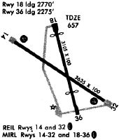
Runway Summary
| Runways: | 14/32 |
| Longest Runway: | 14/32 is 3500 ft (1067 m) long |
| Runways with an Instrument Approach: |
DSV Airport Runway Details
| Runway 14/32 | 3500 ft x 100 ft (1067 m x 30 m) | |
| Runway Length Source: | 3RD PARTY SURVEY as of 11/14/2016 | |
| Surface: | Asphalt - Good condition - No special surface treatment | |
| Runway Edge Lights: | Medium Intensity | |
Runway Weight Bearing Capacity (in thousands of pounds) |
||
| Single Wheel Landing Gear: | 30.0 | |
Runway 14 |
Runway 32 |
|
Elevation: |
635.3 | 659.8 |
Latitude: |
42-34-24.5963N | 42-34-03.2296N |
Longitude: |
077-43-06.1640W | 077-42-29.4019W |
|
Runway True Alignment: |
128 | 308 |
Glide Path Angle: |
3.0 degrees | 4.0 degrees |
Traffic Pattern: |
Left | Left |
Runway Markings Type: |
Basic | Basic |
Runway Markings Condition: |
Fair | Fair |
Object at End: |
FENCE | ROAD |
Object Height: |
6 | 15 |
Distance from End: |
215 | 200 |
Object Centerline Offset: |
250 ft. right of centerline | 200 ft. right of centerline |
Visual Glide Slope Indicators: |
2-Box VASI On Left Side Of Runway | 4-Box VASI On Left Side Of Runway |
REIL: |
No | No |
Threshold Crossing Height: |
35 | 53 |
Services
Airframe Repair: |
None |
Powerplant Repair: |
None |
Bottled Oxygen: |
None |
Bulk Oxygen: |
None |
Fuel Available: |
100LL, Jet A |
Landing Fees: |
No |
Parking: |
Hangars and tiedowns available |
Maps & Diagrams
DSV Sectional
Flight Planning
at skyvector.com
at skyvector.com