Location
Latitude: |
30-12-38.1130N (30.210587) |
Longitude: |
093-08-35.4810W (-93.143189) |
Elevation: |
16.5 feet MSL (5 m MSL) |
Magnetic Variation: |
0.5 E (as of April 2024 from WMM2020 model) |
Time Zone: |
UTC -6.0 (Standard Time) UTC -5.0 (Daylight Savings Time) |
From City: |
04 N.M. E of Lake Charles, Louisiana |
Found On: |
Houston Chart |
FAA Region: |
ASW |
Contacts
Manager: |
Publicly owned: |
| W. KEVIN MELTON 3650 SEN. J. BENNETT JOHNSTON AVE LAKE CHARLES, LA 70615-6849 337-491-9961 |
CHENNAULT INTL ARPT AUTHORITY 3650 SEN. J. BENNETT JOHNSTON AVE LAKE CHARLES, LA 70615-6849 337-491-9961 |
Operations
Airport Status: |
Operational |
Facility Use: |
Public |
Type: |
Airport |
Activation Date: |
01/1964 |
Control tower: |
Yes |
Attendance (Months/Days/Hours): |
Months/Days/Hours ALL/ALL/0600-2200 |
Boundary ARTCC: |
ZHU (Houston) |
Responsible ARTCC: |
ZHU (Houston) |
Lighting Schedule: |
SEE RMK |
Segmented Circle Indicator: |
Yes |
Traffic Pattern Altitude (MSL): |
1016 feet (310 m) |
NOTAMs Facility: |
CWF |
NOTAM-D Service: |
Yes |
International Airport of Entry: |
No |
Customs Landing Rights: |
Yes |
Military Landing Rights: |
Yes |
Civil/Military Joint Use: |
No |
Aircraft Rescue and Firefighting: |
Class IV ARFF Index: A Air Carrier Service: Not Scheduled Certification Date: 07/1992 |
Based Aircraft
| Single Engine: | 15 |
| Multi Engine: | 5 |
| Jet Engine: | 4 |
Annual Operations (as of 02/01/2023)
| Total Operations: | 20814 | |
| Commercial: | 173 | 0.8% |
| Air Taxi: | 906 | 4.4% |
| GA Local: | 2515 | 12.1% |
| GA Itinerant: | 7058 | 33.9% |
| Military Aircraft: | 10162 | 48.8% |
Communications
| CTAF: | 124.200 |
| Unicom: | 122.950 |
| Tower: | CHENNAULT 124.2 290.4 Hrs: 0600-2200 |
| Ground: | 121.65 275.8 |
| Approach: | LAKE CHARLES 119.8 119.8 HOUSTON ARTCC |
| Departure: | LAKE CHARLES 119.8 119.8 HOUSTON ARTCC |
| ATIS: | 120.0 Hrs: 24 |
| AWOS-3: | 120.0 (337-436-3452) |
- APCH/DEP SVC PRVDD BY HOUSTON ARTCC (ZHU) ON FREQS 124.7/317.4 (LAKE CHARLES RCAG) WHEN LAKE CHARLES APCH CTL (LCH) CLSD.
Fixed Based Operators (FBOs) & Fuel
(Click on a business for detail)
Please help us keep this information up to date. This is a FREE SERVICE just like everything else on Airport Guide! If you see that a business needs to be added, modified, or deleted please fill out our Update Form.
To add, modify, or delete a business click here.
Please help us keep this information up to date. This is a FREE SERVICE just like everything else on Airport Guide! If you see that a business needs to be added, modified, or deleted please fill out our Update Form.
Area Code: 337 |
| Business Name | Frequency | Phone | Fuel Grade |
|---|---|---|---|
| Chennault Jet Center
Update FBO info |
Unicom 122.9 | 436-4877 | 100LL, Jet A |
Flight Service Stations
| Primary | Alternate | |
| FSS on Field: | N | |
| FSS Name (ID): | De Ridder(DRI) | |
| Frequency: | ||
| Toll Free Phone: | 1-800-WX-BRIEF |
Instrument Procedures / Charts
FAA Terminal Procedures valid from 0901Z 03/21/24 to 0901Z 04/18/24.
There are various types of charts available for an airport. They are listed in the Page Type column. Here is a legend for those types:
APD - Airport Diagram
DP - Departure Procedure Charts
HOT - Hot Spots
IAP - Instrument Approach Procedure Charts
MIN - Minimums
STAR - Standard Terminal Arrival Charts
| Page Type | Page Name | Volume | Action Since Last Cycle |
|---|---|---|---|
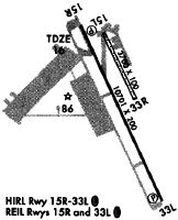
| APD | AIRPORT DIAGRAM | SC-4 | |
| IAP | ILS OR LOC RWY 15 | SC-4 | |
| IAP | RNAV (GPS) RWY 15 | SC-4 | |
| IAP | RNAV (GPS) RWY 33 | SC-4 | |
| MIN | ALTERNATE MINIMUMS | SC-4 | |
| MIN | RADAR MINIMUMS | SC-4 | |
| MIN | TAKEOFF MINIMUMS | SC-4 |
Terminal Procedures are only available for airports in several countries with more being added all the time. If you are looking for a specific country's charts, please send an email to support(at)airportguide.com stating the country name. This will be used to prioritize the implementation.
Navigation Aids (Navaids) near CWF
| Dist (NM) | ID | Morse Code | Name | Type | Freq | True Hdg | Mag Hdg |
|---|---|---|---|---|---|---|---|
| 4.6 | LCH | . _ . . _ . _ . . . . . | Lake Charles | VORTAC | 113.40 | 154 | 154 |
| 6.4 | CW | _ . _ . . _ _ | Mossy | NDB | 418 | 334 | 334 |
| 14.4 | AUR | . _ . . _ . _ . | Sulphur | NDB | 278 | 267 | 266 |
| 21.5 | DQU | _ . . _ _ . _ . . _ | De Quincy | NDB | 410 | 308 | 307 |
| 34.0 | DXB | _ . . _ . . _ _ . . . | De Ridder | NDB | 385 | 343 | 342 |
| 34.8 | ORG | _ _ _ . _ . _ _ . | Orange | NDB | 211 | 256 | 255 |
| 34.9 | LRR | . _ . . . _ . . _ . | Oakdale | NDB | 379 | 42 | 42 |
| 41.6 | ECY | . _ . _ . _ . _ _ | Duralde | NDB | 263 | 59 | 59 |
| 46.1 | POE | . _ _ . _ _ _ . | South | FAN MARKER | 358 | 358 | |
| 48.0 | BPT | _ . . . . _ _ . _ | Beaumont | VOR-DME | 114.50 | 250 | 249 |
| 49.1 | GUV | _ _ . . . _ . . . _ | Gator | NDB | 359 | 357 | 357 |
| 51.8 | LLA | . _ . . . _ . . . _ | White Lake | VOR-DME | 114.95 | 129 | 129 |
| 53.7 | BNZ | _ . . . _ . _ _ . . | Abbeville | NDB | 230 | 99 | 99 |
| 54.2 | POE1 | . _ _ . _ _ _ . | North | FAN MARKER | 355 | 355 | |
| 54.2 | FXU | . . _ . _ . . _ . . _ | Polk | VOR | 108.40 | 355 | 355 |
| 54.5 | VED | . . . _ . _ . . | Leesville | NDB | 247 | 349 | 348 |
| 56.0 | GDE | _ _ . _ . . . | Goodhue | NDB | 368 | 261 | 260 |
| 56.1 | SBI | . . . _ . . . . . | Sabine Pass | VOR-DME | 115.40 | 236 | 235 |
| 58.4 | HRD | . . . . . _ . _ . . | Hardin County | NDB | 524 | 277 | 276 |
| 59.7 | LFT | . _ . . . . _ . _ | Lafayette | VORTAC | 109.80 | 90 | 90 |
Nearby Airports with Fuel
Notices to Airmen (NOTAMS)
Remarks
| A110-1 | INDEX E AVBL WITH 24 HRS NOTICE CALL AMGR 337-491-9961. |
| A110-2 | BIRDS ON & INVOF OF ARPT |
| A110-3 | WHEN ATCT CLSD, FOR CD CTC HOUSTON ARTCC AT 281-230-5622. |
| A110-4 | PPR REQD FOR ACFT / HELO OPS IN THE INDUSTRIAL AREA |
| A110-5 | FOR PORT OF ENTRY REQ, CONTACT THE DIR OF OPS VIA CIAA@CHENNAULT.ORG AT LEAST 3 BUS DAYS (M-F) PRIOR TO PLANNED ARR. |
| A17 | AFT HRS CALL 337-433-7766. |
| A26 | 6 HRS PPR FOR ACR OPNS WITH MORE THAN 30 PSGR SEATS CALL AMGR 337-491-9961. ARFF INDEX E AVAILABLE 24/7 |
| A70-FUEL-10 | 0LL FOR FUEL CALL 337-436-4877. SELF SVC AVBL 24 HRS WITH CREDIT CARD. |
| A81-APT | WHEN ATCT CLSD ACTVT MALSR RWY 15; REIL RWY 33; PAPI RWY 15 & 33; HIRL RWY 15/33 - CTAF. |
| E111 | PRVDD ATCT OPNL TO PRVD ATC SVCS PRIOR TO ACFT OPNS. |
Runways
Runway Summary
| Runways: | 15/33 |
| Longest Runway: | 15/33 is 10702 ft (3262 m) long |
| Runways with an Instrument Approach: | 15 |
CWF Airport Runway Details
| Runway 15/33 | 10702 ft x 200 ft (3262 m x 61 m) | |
| Runway Length Source: | 3RD PARTY SURVEY as of 09/14/2006 | |
| Surface: | Concrete - Fair condition - No special surface treatment | |
| Runway Pavement Class: | 92 /R/C/W/T | |
| Runway Edge Lights: | High Intensity | |
Runway Weight Bearing Capacity (in thousands of pounds) |
||
| Single Wheel Landing Gear: | 120.0 | |
| Dual Wheel Landing Gear: | 250.0 | |
| Dual Tandem Wheel Landing Gear: | 542.0 | |
| Dual Dual Tandem Wheel Landing Gear: | 750.0 | |
Runway 15 |
Runway 33 |
|
Elevation: |
14.4 | 16.3 |
Latitude: |
30-13-25.8893N | 30-11-50.3361N |
Longitude: |
093-09-01.8059W | 093-08-09.1623W |
|
Runway True Alignment: |
154 | 334 |
ILS Type: |
ILS | |
Glide Path Angle: |
3.0 degrees | 3.0 degrees |
Traffic Pattern: |
Right | |
Runway Markings Type: |
Precision Instrument | Precision Instrument |
Runway Markings Condition: |
Fair | Fair |
Visual Glide Slope Indicators: |
4-Light PAPI On Left Side Of Runway | 4-Light PAPI On Left Side Of Runway |
Approach Light System: |
1,400 Foot Medium Intensity Approach Lighting System With Runway Alignment Indicator Lights | |
REIL: |
No | Yes |
Threshold Crossing Height: |
53 | 53 |
Declared Distances |
||
Take Off Run Avbl. (TORA): |
10702 | 10702 |
Take Off Distance Avbl. (TODA): |
10702 | 10702 |
Actual Stop Dist. Avbl. (ASDA): |
10702 | 10702 |
Landing Dist. Avbl. (LDA): |
10702 | 10702 |
Services
Airframe Repair: |
None |
Powerplant Repair: |
None |
Bottled Oxygen: |
None |
Bulk Oxygen: |
None |
Fuel Available: |
100LL |
Landing Fees: |
No |
Parking: |
Tiedowns available |
Maps & Diagrams
CWF Sectional
Flight Planning
at skyvector.com
at skyvector.com