
Location
Latitude: |
21-02-11.4034N (21.036501) |
Longitude: |
086-52-37.5531W (-86.877098) |
Elevation: |
22 feet MSL (7 m MSL) |
Magnetic Variation: |
2.5 W (as of April 2024 from WMM2020 model) |
Time Zone: |
UTC -6.0 (Standard Time) UTC -5.0 (Daylight Savings Time) |
Contacts
Manager: |
: |
Operations
Airport Status: |
Operational |
Facility Use: |
Public |
Type: |
Airport |
Traffic Pattern Altitude (MSL): |
1022 feet (312 m) |
Based Aircraft
Annual Operations (as of )
Communications
| Tower North: | 118.1 |
| Tower South: | 118.6 |
| CLNC DEL: | 122.1 |
| GND: | 121.7 |
| APP: | 120.4 |
| DEP: | 119.8 |
| ATIS: | 127.7 |
| ARR: | 120.4 |
Fixed Based Operators (FBOs) & Fuel
(Click on a business for detail)
Please help us keep this information up to date. This is a FREE SERVICE just like everything else on Airport Guide! If you see that a business needs to be added, modified, or deleted please fill out our Update Form.
To add, modify, or delete a business click here.
Please help us keep this information up to date. This is a FREE SERVICE just like everything else on Airport Guide! If you see that a business needs to be added, modified, or deleted please fill out our Update Form.
| Business Name | Frequency | Phone | Fuel Grade |
|---|
Flight Service Stations
| Primary | Alternate | |
| FSS on Field: | ||
| FSS Name (ID): | ||
| Frequency: | ||
| Toll Free Phone: |
Instrument Procedures / Charts
Terminal Procedures are only available for airports in several countries with more being added all the time. If you are looking for a specific country's charts, please send an email to support(at)airportguide.com stating the country name. This will be used to prioritize the implementation.
Navigation Aids (Navaids) near CUN
Nearby Airports with Fuel
| Dist (NM) | Name (Airport IDs) | True Hdg | Mag Hdg | Fuel Grade |
|---|
Notices to Airmen (NOTAMS)
Remarks
No remarks for this landing facility
Runways
Runway Summary
| Runways: | 12L/30R 12R/30L |
| Longest Runway: | 12R/30L is 11483 ft (3500 m) long |
| Runways with an Instrument Approach: |
CUN Airport Runway Details
| Runway 12L/30R | 9186 ft x 148 ft (2800 m x 45 m) | |
| Runway Edge Lights: | Yes Intensity | |
Runway 12L |
Runway 30R |
|
Elevation: |
22 | 18 |
Latitude: |
21.05470275878 | 21.04065895080 |
Longitude: |
-86.88137817382 | -86.85896301269 |
|
Runway True Alignment: |
123.6 | 303.6 |
Glide Path Angle: |
0.0 degrees | 0.0 degrees |
REIL: |
Yes | Yes |
Threshold Elevation: |
22 | 18 |
| Runway 12R/30L | 11483 ft x 197 ft (3500 m x 60 m) | |
| Runway Edge Lights: | Yes Intensity | |
Runway 12R |
Runway 30L |
|
Elevation: |
20 | 18 |
Latitude: |
21.04529953002 | 21.02779960632 |
Longitude: |
-86.89099884033 | -86.86289978027 |
|
Runway True Alignment: |
123.6 | 303.6 |
Glide Path Angle: |
0.0 degrees | 0.0 degrees |
REIL: |
Yes | Yes |
Threshold Elevation: |
20 | 18 |
Services
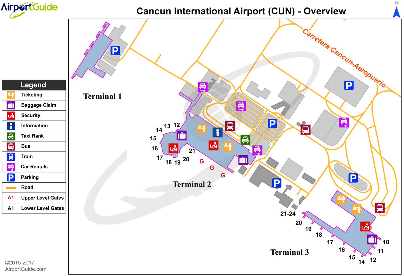
Maps & Diagrams
CUN Sectional
Flight Planning
at skyvector.com
at skyvector.com
