Location
Latitude: |
66-38-42.1000N (66.645028) |
Longitude: |
143-44-23.6000W (-143.739889) |
Elevation: |
548.5 feet MSL (167 m MSL) |
Magnetic Variation: |
17.1 E (as of April 2024 from WMM2020 model) |
Time Zone: |
UTC -9.0 (Standard Time) UTC -8.0 (Daylight Savings Time) |
From City: |
00 N.M. SW of Chalkyitsik, Alaska |
Found On: |
Dawson Chart |
FAA Region: |
AAL |
Contacts
Manager: |
Publicly owned: |
| JASON LUDINGTON 2301 PEGER RD FAIRBANKS, AK 99709 (907) 451-5280 |
ALASKA DOT&PF NORTHERN REGION 2301 PEGER RD FAIRBANKS, AK 99709 (907) 451-5280 |
Operations
Airport Status: |
Operational |
Facility Use: |
Public |
Type: |
Airport |
Activation Date: |
09/1958 |
Control tower: |
No |
Attendance (Months/Days/Hours): |
Months/Days/Hours Unattended |
Boundary ARTCC: |
ZAN (Anchorage) |
Responsible ARTCC: |
ZAN (Anchorage) |
Lighting Schedule: |
SEE RMK |
Segmented Circle Indicator: |
Yes |
Traffic Pattern Altitude (MSL): |
1548 feet (472 m) |
NOTAMs Facility: |
FAI |
NOTAM-D Service: |
Yes |
Based Aircraft
Annual Operations (as of 12/31/2020)
| Total Operations: | 650 | |
| Air Taxi: | 500 | 76.9% |
| GA Itinerant: | 150 | 23.1% |
Communications
| CTAF: | 122.900 |
- APCH/DEP SVC PRVDD BY ANCHORAGE ARTCC ON FREQS 135.0/225.4 (FORT YUKON RCAG).
Fixed Based Operators (FBOs) & Fuel
(Click on a business for detail)
Please help us keep this information up to date. This is a FREE SERVICE just like everything else on Airport Guide! If you see that a business needs to be added, modified, or deleted please fill out our Update Form.
To add, modify, or delete a business click here.
Please help us keep this information up to date. This is a FREE SERVICE just like everything else on Airport Guide! If you see that a business needs to be added, modified, or deleted please fill out our Update Form.
Area Code: 907 |
| Business Name | Frequency | Phone | Fuel Grade |
|---|
Flight Service Stations
| Primary | Alternate | |
| FSS on Field: | ||
| FSS Name (ID): | Fairbanks(FAI) | |
| Frequency: | ||
| Toll Free Phone: | 1-866-248-6516 |
Instrument Procedures / Charts
FAA Terminal Procedures valid from 0901Z 03/21/24 to 0901Z 04/18/24.
There are various types of charts available for an airport. They are listed in the Page Type column. Here is a legend for those types:
APD - Airport Diagram
DP - Departure Procedure Charts
HOT - Hot Spots
IAP - Instrument Approach Procedure Charts
MIN - Minimums
STAR - Standard Terminal Arrival Charts
| Page Type | Page Name | Volume | Action Since Last Cycle |
|---|---|---|---|
| IAP | RNAV (GPS) RWY 04 | AK-1 | |
| IAP | RNAV (GPS) RWY 22 | AK-1 | |
| MIN | TAKEOFF MINIMUMS | AK-1 |
Terminal Procedures are only available for airports in several countries with more being added all the time. If you are looking for a specific country's charts, please send an email to support(at)airportguide.com stating the country name. This will be used to prioritize the implementation.
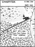
Navigation Aids (Navaids) near CIK
Nearby Airports with Fuel
| Dist (NM) | Name (Airport IDs) | True Hdg | Mag Hdg | Fuel Grade |
|---|
Notices to Airmen (NOTAMS)
Remarks
| A110-1 | SNOW REMOVAL OPERATIONS DURING WINTER--MONITOR CTAF. |
| A110-2 | RWY COND NOT MONITORED; RECOMMEND VISUAL INSPECTION PRIOR TO LANDING. |
| A110-3 | WX CAMERA AVBL ON INTERNET AT HTTPS://WEATHERCAMS.FAA.GOV. |
| A110-4 | RWY 04/22 SOFT WHEN WET. |
| A110-6 | EAST RAMP ENTRANCE UNLIT. |
| A110-7 | EAST RAMP ENTRANCE REFLECTORS 36 INCHES TALL. |
| A51-22 | DSPLCD THLD MKD WITH LGTS & REFLECTORS. |
| A81-APT | ACTVT MIRL RWY 04/22 - CTAF. |
| A81-BCN | SS-SR. ACTVT BEACON - CTAF. |
Runways
Runway Summary
| Runways: | 04/22 |
| Longest Runway: | 04/22 is 4000 ft (1219 m) long |
| Runways with an Instrument Approach: |
CIK Airport Runway Details
| Runway 04/22 | 4000 ft x 75 ft (1219 m x 23 m) | |
| Runway Length Source: | 3RD PARTY SURVEY as of 06/28/2012 | |
| Surface: | Gravel/Dirt - Fair condition - No special surface treatment | |
| Runway Edge Lights: | Medium Intensity | |
Runway 04 |
Runway 22 |
|
Elevation: |
528.7 | 548.5 |
Latitude: |
66-38-30.3773N | 66-38-53.8002N |
Longitude: |
143-45-03.4668W | 143-43-43.7731W |
|
Runway True Alignment: |
053 | 233 |
Glide Path Angle: |
0.0 degrees | 0.0 degrees |
Traffic Pattern: |
Left | Left |
Runway Markings Type: |
None | None |
Runway Markings Condition: |
Fair | Fair |
Object at End: |
TREES | TREES |
Object Height: |
32 | 15 |
Distance from End: |
0 | 0 |
Object Centerline Offset: |
134 ft. left and right of centerline | 120 ft. left and right of centerline |
Threshold Elevation: |
545.3 | |
Displaced Threshold: |
500 | |
Threshold Latitude: |
66-38-50.8727N | |
Threshold Longitude: |
143-43-53.7382W |
Services
Maps & Diagrams
CIK Sectional
Flight Planning
at skyvector.com
at skyvector.com