Location
Latitude: |
35-02-06.7000N (35.035194) |
Longitude: |
085-12-12.8000W (-85.203556) |
Elevation: |
682.5 feet MSL (208 m MSL) |
Magnetic Variation: |
5.1 W (as of April 2024 from WMM2020 model) |
Time Zone: |
UTC -5.0 (Standard Time) UTC -4.0 (Daylight Savings Time) |
From City: |
05 N.M. E of Chattanooga, Tennessee |
Found On: |
Atlanta Chart |
FAA Region: |
ASO |
Contacts
Manager: |
Publicly owned: |
| TERRY HART 1001 AIRPORT ROAD, SUITE 14 CHATTANOOGA, TN 37421 423-855-2200 |
CHATTANOOGA METRO ARPT AUTH 1001 AIRPORT ROAD, SUITE 14 CHATTANOOGA, TN 37421 423-855-2200 |
Operations
Airport Status: |
Operational |
Facility Use: |
Public |
Type: |
Airport |
Activation Date: |
11/1937 |
Control tower: |
Yes |
Attendance (Months/Days/Hours): |
Months/Days/Hours ALL/ALL/ALL |
Boundary ARTCC: |
ZTL (Atlanta) |
Responsible ARTCC: |
ZTL (Atlanta) |
Lighting Schedule: |
SEE RMK |
Segmented Circle Indicator: |
Yes |
Traffic Pattern Altitude (MSL): |
1682 feet (513 m) |
NOTAMs Facility: |
CHA |
NOTAM-D Service: |
Yes |
International Airport of Entry: |
No |
Customs Landing Rights: |
Yes |
Military Landing Rights: |
Yes |
Civil/Military Joint Use: |
No |
Aircraft Rescue and Firefighting: |
Class I ARFF Index: B Air Carrier Service: Scheduled Certification Date: 05/1973 |
Based Aircraft
| Single Engine: | 44 |
| Multi Engine: | 9 |
| Jet Engine: | 45 |
| GA Helicopters: | 2 |
Annual Operations (as of 05/31/2022)
| Total Operations: | 89638 | |
| Commercial: | 8546 | 9.5% |
| Air Taxi: | 12583 | 14.0% |
| GA Local: | 21011 | 23.4% |
| GA Itinerant: | 38727 | 43.2% |
| Military Aircraft: | 8771 | 9.8% |
Communications
| CTAF: | 118.300 |
| Unicom: | 122.950 |
| Tower: | CHATTANOOGA 118.3 257.8 Hrs: 0600-2350 |
| Clearance Del.: | 120.95 348.6 |
| Ground: | 121.7 348.6 |
| Approach: | CHATTANOOGA 125.1 379.1 Hrs: 0600-2350 ATLANTA ARTCC 126.5 Hrs: 2350-0600 |
| Departure: | CHATTANOOGA 125.1 379.1 Hrs: 0600-2350 ATLANTA ARTCC 126.5 Hrs: 2350-0600 |
| ATIS: | 119.85 Hrs: 24 |
| ASOS: | 119.85 (423-499-5973) |
| EMERG: | 243.0 |
| EMERG: | 121.5 |
| NG OPS: | 373.9 |
| CLASS C: | 125.1 |
| CLASS C: | 379.1 |
| NG OPS: | 41.5FM |
| NG OPS: | 149.8 |
- APCH/DEP SVC PRVDD BY ATLANTA ARTCC ON FREQS 132.05/354.025 (CHATTANOOGA RCAG) WHEN CHATTANOOGA APCH CTL CLSD.
Fixed Based Operators (FBOs) & Fuel
(Click on a business for detail)
Please help us keep this information up to date. This is a FREE SERVICE just like everything else on Airport Guide! If you see that a business needs to be added, modified, or deleted please fill out our Update Form.
To add, modify, or delete a business click here.
Please help us keep this information up to date. This is a FREE SERVICE just like everything else on Airport Guide! If you see that a business needs to be added, modified, or deleted please fill out our Update Form.
Area Code: 423 |
| Business Name | Frequency | Phone | Fuel Grade |
|---|---|---|---|
| Chattanooga Aero Service
Update FBO info |
892-2121 | ||
| Ellsworth Aviation
Update FBO info |
Unicom 123.3 | 894-4930 | |
| Krystal Aviation South
Update FBO info |
490-4620, after hours call 605-1408 | 100LL, Jet A | |
| Krystal Aviation-Avitat North
Update FBO info |
490-4600, after hours call 605-1408 | 100LL, Jet A | |
| Star Avionics, Inc.
Update FBO info |
499-1100 |
Flight Service Stations
| Primary | Alternate | |
| FSS on Field: | N | |
| FSS Name (ID): | Nashville(BNA) | |
| Frequency: | ||
| Toll Free Phone: | 1-800-WX-BRIEF |
Instrument Procedures / Charts
FAA Terminal Procedures valid from 0901Z 03/21/24 to 0901Z 04/18/24.
There are various types of charts available for an airport. They are listed in the Page Type column. Here is a legend for those types:
APD - Airport Diagram
DP - Departure Procedure Charts
HOT - Hot Spots
IAP - Instrument Approach Procedure Charts
MIN - Minimums
STAR - Standard Terminal Arrival Charts
| Page Type | Page Name | Volume | Action Since Last Cycle |
|---|---|---|---|
| APD | AIRPORT DIAGRAM | SE-1 | |
| DP | CHATTANOOGA EIGHT | SE-1 | |
| IAP | ILS OR LOC RWY 02 | SE-1 | |
| IAP | ILS OR LOC RWY 20 | SE-1 | |
| IAP | ILS RWY 20 (CAT II) | SE-1 | |
| IAP | RNAV (GPS) RWY 02 | SE-1 | |
| IAP | RNAV (GPS) RWY 15 | SE-1 | |
| IAP | RNAV (GPS) RWY 20 | SE-1 | |
| IAP | RNAV (GPS) RWY 33 | SE-1 | |
| MIN | ALTERNATE MINIMUMS | SE-1 | |
| MIN | TAKEOFF MINIMUMS | SE-1 |
Terminal Procedures are only available for airports in several countries with more being added all the time. If you are looking for a specific country's charts, please send an email to support(at)airportguide.com stating the country name. This will be used to prioritize the implementation.
Navigation Aids (Navaids) near CHA
| Dist (NM) | ID | Morse Code | Name | Type | Freq | True Hdg | Mag Hdg |
|---|---|---|---|---|---|---|---|
| 5.1 | GQO | _ _ . _ _ . _ _ _ _ | Choo Choo | DME | 115.8 | 150 | 155 |
| 8.2 | CQN | _ . _ . _ _ . _ _ . | Daisy | NDB | 341 | 16 | 21 |
| 16.3 | HDI | . . . . _ . . . . | Hardwick | NDB | 369 | 63 | 68 |
| 18.7 | APT | . _ . _ _ . _ | Jasper | NDB | 382 | 274 | 279 |
| 19.4 | UWI | . . _ . _ _ . . | Whitfield | NDB | 400 | 138 | 143 |
| 29.9 | DTE | _ . . _ . | Mark Anton | NDB | 394 | 26 | 31 |
| 38.1 | MMI | _ _ _ _ . . | Mc Minn County | NDB | 242 | 55 | 60 |
| 38.6 | FTP | . . _ . _ . _ _ . | Fort Payne | NDB | 426 | 217 | 222 |
| 40.4 | OUK | _ _ _ . . _ _ . _ | Calhoun | NDB | 323 | 160 | 165 |
| 43.3 | BGF | _ . . . _ _ . . . _ . | Boiling Fork | NDB | 263 | 281 | 286 |
| 46.1 | HCH | . . . . _ . _ . . . . . | Hinch Mountain | VOR-DME | 117.60 | 13 | 18 |
| 50.5 | MNV | _ _ _ . . . . _ | Madisonville | NDB | 361 | 52 | 57 |
| 51.0 | RN | . _ . _ . | Warri | NDB | 209 | 327 | 332 |
| 52.5 | RMG | . _ . _ _ _ _ . | Rome | VORTAC | 115.40 | 175 | 180 |
| 53.2 | EVZ | . . . . _ _ _ . . | Cartersville | NDB | 308 | 160 | 165 |
| 55.1 | UXM | . . _ _ . . _ _ _ | Tullahoma Regional | VOR | 109.65 | 292 | 297 |
| 56.9 | ULH | . . _ . _ . . . . . . | Burwi | NDB | 332 | 296 | 301 |
| 58.8 | DJD | _ . . . _ _ _ _ . . | Chero | NDB | 415 | 142 | 147 |
| 60.1 | HEM | . . . . . _ _ | Huchn | NDB | 233 | 342 | 347 |
| 63.5 | HRS | . . . . . _ . . . . | Harris | VORTAC | 109.80 | 94 | 100 |
Nearby Airports with Fuel
Notices to Airmen (NOTAMS)
Remarks
| A110-2 | TSNT ACFT AVOID SCTY ZONE WI 300 FT OF TRML BLDG. |
| A110-3 | BIRDS INVOF ARPT. |
| A110-4 | HOLD SHORT INSTR READ BACK RQRD. |
| A110-5 | FOR CD IF UNA TO CTC ON FSS FREQ, CTC CHATTANOOGA APCH AT 423-855-6478, WHEN APCH CLSD CTC ATLANTA ARTCC AT 770-210-7692. |
| A26 | ARFF INDEX C AVBL O/R. |
| A57-15 | APCH SLOPE 25:1 TO DSPLCD THR. |
| A57-33 | APCH SLOPE 25:1 TO DSPLCD THR. |
| A81-APT | ACTVT MALSR RWY 02; TDZL RWY 20; CNTRLN LGTS RWY 02/20; HIRL RWY 02/20 - CTAF. MIRL RWY 15/33 UNAVBL WHEN ATCT CLSD. |
Runways
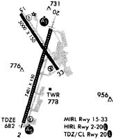
Runway Summary
| Runways: | 02/20 15/33 |
| Longest Runway: | 02/20 is 7400 ft (2256 m) long |
| Runways with an Instrument Approach: | 02, 20 |
CHA Airport Runway Details
| Runway 02/20 | 7400 ft x 150 ft (2256 m x 46 m) | |
| Runway Length Source: | 3RD PARTY SURVEY as of 12/08/2015 | |
| Surface: | Asphalt - Good condition - Saw-cut or plastic grooved | |
| Runway Pavement Class: | 42 /F/A/X/U | |
| Runway Edge Lights: | High Intensity | |
Runway Weight Bearing Capacity (in thousands of pounds) |
||
| Single Wheel Landing Gear: | 120.0 | |
| Dual Wheel Landing Gear: | 164.0 | |
| Dual Tandem Wheel Landing Gear: | 265.0 | |
Runway 02 |
Runway 20 |
|
Elevation: |
681.3 | 667.1 |
Latitude: |
35-01-21.5461N | 35-02-31.6459N |
Longitude: |
085-12-27.0143W | 085-12-01.4372W |
|
Runway True Alignment: |
017 | 197 |
ILS Type: |
ILS | ILS |
Glide Path Angle: |
3.0 degrees | 0.0 degrees |
Traffic Pattern: |
Left | Left |
Runway Markings Type: |
Precision Instrument | Precision Instrument |
Runway Markings Condition: |
Good | Good |
Object at End: |
RR | |
Object Height: |
28 | |
Distance from End: |
850 | |
Object Centerline Offset: |
600 ft. left of centerline | |
Visual Glide Slope Indicators: |
4-Light PAPI On Right Side Of Runway | |
Runway Visual Range (RVR): |
Touchdown, Rollout | Touchdown, Rollout |
Approach Light System: |
1,400 Foot Medium Intensity Approach Lighting System With Runway Alignment Indicator Lights | Standard 2,400 Foot High Intensity Approach Lighting System With Sequenced Flashers, Cat. II or III Config. |
Touchdown Lights: |
No | Yes |
Centerline Lights: |
Yes | Yes |
Threshold Crossing Height: |
71 | |
Declared Distances |
||
Take Off Run Avbl. (TORA): |
7400 | 7400 |
Take Off Distance Avbl. (TODA): |
7400 | 7400 |
Actual Stop Dist. Avbl. (ASDA): |
7100 | 7400 |
Landing Dist. Avbl. (LDA): |
7100 | 7400 |
| Runway 15/33 | 5575 ft x 150 ft (1699 m x 46 m) | |
| Runway Length Source: | 3RD PARTY SURVEY as of 12/08/2015 | |
| Surface: | Asphalt - Good condition - Saw-cut or plastic grooved | |
| Runway Pavement Class: | 14 /F/A/Y/U | |
| Runway Edge Lights: | Medium Intensity | |
Runway Weight Bearing Capacity (in thousands of pounds) |
||
| Single Wheel Landing Gear: | 120.0 | |
| Dual Wheel Landing Gear: | 164.0 | |
| Dual Tandem Wheel Landing Gear: | 265.0 | |
Runway 15 |
Runway 33 |
|
Elevation: |
670.6 | 674.9 |
Latitude: |
35-02-42.8237N | 35-01-57.3916N |
Longitude: |
085-12-29.8965W | 085-11-51.9002W |
|
Runway True Alignment: |
145 | 325 |
Glide Path Angle: |
3.0 degrees | 3.0 degrees |
Traffic Pattern: |
Left | Left |
Runway Markings Type: |
Nonprecision Instrument | Nonprecision Instrument |
Runway Markings Condition: |
Good | Good |
Object at End: |
TREES | TREES |
Object Height: |
3 | 44 |
Distance from End: |
1000 | 1000 |
Object Centerline Offset: |
600 ft. left of centerline | |
Visual Glide Slope Indicators: |
4-Light PAPI On Left Side Of Runway | 4-Light PAPI On Left Side Of Runway |
Threshold Crossing Height: |
45 | 40 |
Threshold Elevation: |
670.6 | 671.6 |
Displaced Threshold: |
106 | 575 |
Threshold Latitude: |
35-02-41.9645N | 35-02-02.0796N |
Threshold Longitude: |
085-12-29.1750W | 085-11-55.8191W |
Declared Distances |
||
Take Off Run Avbl. (TORA): |
5575 | 5470 |
Take Off Distance Avbl. (TODA): |
5575 | 5470 |
Actual Stop Dist. Avbl. (ASDA): |
5575 | 5470 |
Landing Dist. Avbl. (LDA): |
5470 | 5000 |
Services
Airframe Repair: |
Minor |
Powerplant Repair: |
Minor |
Bottled Oxygen: |
None |
Bulk Oxygen: |
None |
Fuel Available: |
100LL |
Landing Fees: |
No |
Parking: |
Tiedowns available |
Maps & Diagrams
CHA Sectional
Flight Planning
at skyvector.com
at skyvector.com