Location
Latitude: |
33-37-22.1000N (33.622806) |
Longitude: |
092-45-48.2000W (-92.763389) |
Elevation: |
129.6 feet MSL (40 m MSL) |
Magnetic Variation: |
0.1 E (as of April 2024 from WMM2020 model) |
Time Zone: |
UTC -6.0 (Standard Time) UTC -5.0 (Daylight Savings Time) |
From City: |
05 N.M. NE of Camden, Arkansas |
Found On: |
Memphis Chart |
FAA Region: |
ASW |
Contacts
Manager: |
Publicly owned: |
| KYLE GATLING 255 AIRPORT RD CAMDEN, AR 71701 870-818-3408 |
CITY OF CAMDEN PO BOX 278 CAMDEN, AR 71711 870-836-6436 |
Operations
Airport Status: |
Operational |
Facility Use: |
Public |
Type: |
Airport |
Activation Date: |
10/1944 |
Control tower: |
No |
Attendance (Months/Days/Hours): |
Months/Days/Hours ALL/MON-FRI/0800-1630 |
Boundary ARTCC: |
ZFW (Fort Worth) |
Responsible ARTCC: |
ZFW (Fort Worth) |
Lighting Schedule: |
SEE RMK |
Segmented Circle Indicator: |
Yes |
Traffic Pattern Altitude (MSL): |
1130 feet (344 m) |
NOTAMs Facility: |
JBR |
NOTAM-D Service: |
Yes |
International Airport of Entry: |
No |
Customs Landing Rights: |
No |
Military Landing Rights: |
Yes |
Civil/Military Joint Use: |
No |
Based Aircraft
| Single Engine: | 8 |
| Multi Engine: | 5 |
| Jet Engine: | 1 |
Annual Operations (as of 08/31/2021)
| Total Operations: | 15150 | |
| GA Local: | 4750 | 31.4% |
| GA Itinerant: | 10000 | 66.0% |
| Military Aircraft: | 400 | 2.6% |
Communications
| CTAF: | 122.700 |
| Unicom: | 122.700 |
| AWOS-3: | 125.2 (870-574-1011) |
- APCH/DEP CTL SVC PRVDD BY FORT WORTH ARTCC (ZFW) ON FREQS 128.2/269.1 (EL DORADO RCAG).
Fixed Based Operators (FBOs) & Fuel
(Click on a business for detail)
Please help us keep this information up to date. This is a FREE SERVICE just like everything else on Airport Guide! If you see that a business needs to be added, modified, or deleted please fill out our Update Form.
To add, modify, or delete a business click here.
Please help us keep this information up to date. This is a FREE SERVICE just like everything else on Airport Guide! If you see that a business needs to be added, modified, or deleted please fill out our Update Form.
Area Code: 870 |
| Business Name | Frequency | Phone | Fuel Grade |
|---|---|---|---|
| Camden Flying Service
Update FBO info |
574-2642 | 100LL, Jet A |
Flight Service Stations
| Primary | Alternate | |
| FSS on Field: | N | |
| FSS Name (ID): | Jonesboro(JBR) | |
| Frequency: | ||
| Toll Free Phone: | 1-800-WX-BRIEF |
Instrument Procedures / Charts
FAA Terminal Procedures valid from 0901Z 03/21/24 to 0901Z 04/18/24.
There are various types of charts available for an airport. They are listed in the Page Type column. Here is a legend for those types:
APD - Airport Diagram
DP - Departure Procedure Charts
HOT - Hot Spots
IAP - Instrument Approach Procedure Charts
MIN - Minimums
STAR - Standard Terminal Arrival Charts
| Page Type | Page Name | Volume | Action Since Last Cycle |
|---|---|---|---|
| IAP | RNAV (GPS) RWY 01 | SC-1 | |
| IAP | RNAV (GPS) RWY 19 | SC-1 | |
| MIN | ALTERNATE MINIMUMS | SC-1 | |
| MIN | TAKEOFF MINIMUMS | SC-1 |
Terminal Procedures are only available for airports in several countries with more being added all the time. If you are looking for a specific country's charts, please send an email to support(at)airportguide.com stating the country name. This will be used to prioritize the implementation.
Navigation Aids (Navaids) near CDH
| Dist (NM) | ID | Morse Code | Name | Type | Freq | True Hdg | Mag Hdg |
|---|---|---|---|---|---|---|---|
| 20.3 | EL | . . _ . . | Lados | NDB | 418 | 174 | 174 |
| 22.0 | ELD | . . _ . . _ . . | El Dorado | VOR-DME | 115.50 | 177 | 177 |
| 31.1 | ADF | . _ _ . . . . _ . | Arkadelphia | NDB | 275 | 326 | 326 |
| 44.7 | HPC | . . . . . _ _ . _ . _ . | Hope | NDB | 362 | 277 | 277 |
| 52.5 | HO | . . . . _ _ _ | Hossy | NDB | 385 | 336 | 336 |
| 52.5 | MON | _ _ _ _ _ _ . | Monticello | DME | 111.6 | 93 | 93 |
| 53.9 | HOT | . . . . _ _ _ _ | Hot Springs | VOR-DME | 110.00 | 342 | 342 |
| 56.0 | PBF | . _ _ . _ . . . . . _ . | Pine Bluff | VOR-DME | 116.00 | 47 | 47 |
| 57.4 | TX | _ _ . . _ | Tecco | NDB | 234 | 264 | 264 |
| 61.5 | ROQ | . _ . _ _ _ _ _ . _ | Ruston | NDB | 368 | 171 | 171 |
| 65.8 | TXK | _ _ . . _ _ . _ | Texarkana | VORTAC | 116.30 | 264 | 263 |
| 66.8 | LI | . _ . . . . | Lasky | NDB | 353 | 19 | 19 |
| 68.3 | BQP | _ . . . _ _ . _ . _ _ . | Bastrop | NDB | 329 | 139 | 139 |
| 69.6 | LIT | . _ . . . . _ | Little Rock | VORTAC | 113.90 | 24 | 24 |
| 73.3 | EIC | . . . _ . _ . | Belcher | VORTAC | 117.40 | 226 | 226 |
| 73.4 | TUF | _ . . _ . . _ . | Stuckey | NDB | 350 | 173 | 173 |
| 75.8 | MLU | _ _ . _ . . . . _ | Monroe | VORTAC | 117.20 | 150 | 150 |
| 77.5 | VIV | . . . _ . . . . . _ | Vivian | NDB | 284 | 234 | 233 |
| 77.6 | ML | _ _ . _ . . | Sabar | NDB | 392 | 154 | 154 |
| 78.0 | ATA | . _ _ . _ | Atlanta | NDB | 347 | 246 | 245 |
Nearby Airports with Fuel
Notices to Airmen (NOTAMS)
Remarks
| A110*G | THIS AIRPORT HAS BEEN SURVEYED BY THE NATIONAL GEODETIC SURVEY. |
| A110-1 | DEER ON & INVOF ARPT. |
| A110-4 | ULTRALIGHT ACTIVITY ON & INVOF ARPT. |
| A110-5 | FOR CD CTC FORT WORTH ARTCC AT 817-858-7584. |
| A17 | FOR SVC AFT HRS CALL 870-818-3408. |
| A70-FUEL-10 | 0LL FUEL AVBL SELF SERVE 24 HRS WITH CREDIT CARD (100LL & JET A). |
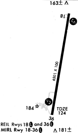
| A81-APT | ACTVT MIRL RY 18/36, PAPI RYS 18 & 36 AND REIL RYS 18 & 36 - CTAF. |
Runways
Runway Summary
| Runways: | 01/19 |
| Longest Runway: | 01/19 is 6502 ft (1982 m) long |
| Runways with an Instrument Approach: |
CDH Airport Runway Details
| Runway 01/19 | 6502 ft x 100 ft (1982 m x 30 m) | |
| Runway Length Source: | NGS as of 07/30/2008 | |
| Surface: | Asphalt - Good condition - Saw-cut or plastic grooved | |
| Runway Edge Lights: | Medium Intensity | |
Runway Weight Bearing Capacity (in thousands of pounds) |
||
| Single Wheel Landing Gear: | 86.0 | |
| Dual Wheel Landing Gear: | 112.0 | |
| Dual Tandem Wheel Landing Gear: | 180.0 | |
Runway 01 |
Runway 19 |
|
Elevation: |
122.9 | 129.6 |
Latitude: |
33-36-50.3111N | 33-37-53.8294N |
Longitude: |
092-45-54.2810W | 092-45-42.1622W |
|
Runway True Alignment: |
009 | 189 |
Glide Path Angle: |
3.0 degrees | 3.0 degrees |
Traffic Pattern: |
Left | Left |
Runway Markings Type: |
Nonprecision Instrument | Nonprecision Instrument |
Runway Markings Condition: |
Fair | Fair |
Object at End: |
TREES | TREES |
Object Height: |
45 | 55 |
Distance from End: |
1050 | 600 |
Object Centerline Offset: |
360 ft. right of centerline | 250 ft. right of centerline |
Visual Glide Slope Indicators: |
2-Light PAPI On Left Side Of Runway | 2-Light PAPI On Left Side Of Runway |
REIL: |
Yes | Yes |
Threshold Crossing Height: |
45 | 43 |
Services
Airframe Repair: |
Major |
Powerplant Repair: |
Major |
Bottled Oxygen: |
None |
Bulk Oxygen: |
None |
Fuel Available: |
100LL |
Landing Fees: |
No |
Parking: |
Tiedowns available |
Maps & Diagrams
CDH Sectional
Flight Planning
at skyvector.com
at skyvector.com