Location
Latitude: |
43-06-51.5880N (43.11433) |
Longitude: |
089-31-53.9360W (-89.531649) |
Elevation: |
928.0 feet MSL (283 m MSL) |
Magnetic Variation: |
2.8 W (as of April 2024 from WMM2020 model) |
Time Zone: |
UTC -6.0 (Standard Time) UTC -5.0 (Daylight Savings Time) |
From City: |
05 N.M. NW of Middleton, Wisconsin |
Found On: |
Chicago Chart |
FAA Region: |
AGL |
Contacts
Manager: |
Publicly owned: |
| RICHARD MOREY 8300 AIRPORT ROAD, 7426 HUBBARD AVE MIDDLETON, WI 53562 608-836-1711 |
CITY OF MIDDLETON 7426 HUBBARD AVENUE MIDDLETON, WI 53562 608-827-1050 |
Operations
Airport Status: |
Operational |
Facility Use: |
Public |
Type: |
Airport |
Activation Date: |
09/1948 |
Control tower: |
No |
Attendance (Months/Days/Hours): |
Months/Days/Hours ALL/ALL/0800-1730 |
Boundary ARTCC: |
ZAU (Chicago) |
Responsible ARTCC: |
ZAU (Chicago) |
Lighting Schedule: |
SEE RMK |
Segmented Circle Indicator: |
No |
Traffic Pattern Altitude (MSL): |
1928 feet (588 m) |
NOTAMs Facility: |
GRB |
NOTAM-D Service: |
Yes |
International Airport of Entry: |
No |
Customs Landing Rights: |
No |
Military Landing Rights: |
No |
Civil/Military Joint Use: |
No |
Based Aircraft
| Single Engine: | 80 |
| Multi Engine: | 5 |
| Jet Engine: | 2 |
| GA Helicopters: | 4 |
Annual Operations (as of 07/12/2023)
| Total Operations: | 40510 | |
| Air Taxi: | 2500 | 6.2% |
| GA Local: | 25000 | 61.7% |
| GA Itinerant: | 13000 | 32.1% |
| Military Aircraft: | 10 | 0.0% |
Communications
| CTAF: | 123.000 |
| Unicom: | 123.000 |
| Approach: | MADISON 135.45 135.45 CHICAGO ARTCC |
| Departure: | MADISON 135.45 135.45 CHICAGO ARTCC |
| AWOS-3: | 118.675 (608-833-1686) |
- APCH/DEP SVC PRVDD BY CHICAGO ARTCC ON FREQS 133.3/257.925 (LONE ROCK RCAG) WHEN MADISON APCH CTL CLSD.
Fixed Based Operators (FBOs) & Fuel
(Click on a business for detail)
Please help us keep this information up to date. This is a FREE SERVICE just like everything else on Airport Guide! If you see that a business needs to be added, modified, or deleted please fill out our Update Form.
To add, modify, or delete a business click here.
Please help us keep this information up to date. This is a FREE SERVICE just like everything else on Airport Guide! If you see that a business needs to be added, modified, or deleted please fill out our Update Form.
Area Code: 608 |
| Business Name | Frequency | Phone | Fuel Grade |
|---|---|---|---|
| Morey Airplane Co.
Update FBO info |
Unicom 123.0 | 836-1711 | 100LL |
Flight Service Stations
| Primary | Alternate | |
| FSS on Field: | N | |
| FSS Name (ID): | Green Bay(GRB) | |
| Frequency: | ||
| Toll Free Phone: | 1-800-WX-BRIEF |
Instrument Procedures / Charts
FAA Terminal Procedures valid from 0901Z 03/21/24 to 0901Z 04/18/24.
There are various types of charts available for an airport. They are listed in the Page Type column. Here is a legend for those types:
APD - Airport Diagram
DP - Departure Procedure Charts
HOT - Hot Spots
IAP - Instrument Approach Procedure Charts
MIN - Minimums
STAR - Standard Terminal Arrival Charts
| Page Type | Page Name | Volume | Action Since Last Cycle |
|---|---|---|---|
| IAP | LOC/DME RWY 10 | EC-3 | |
| IAP | RNAV (GPS) RWY 10 | EC-3 | |
| IAP | RNAV (GPS) RWY 28 | EC-3 | |
| IAP | VOR RWY 28 | EC-3 | |
| MIN | ALTERNATE MINIMUMS | EC-3 | |
| MIN | TAKEOFF MINIMUMS | EC-3 |
Terminal Procedures are only available for airports in several countries with more being added all the time. If you are looking for a specific country's charts, please send an email to support(at)airportguide.com stating the country name. This will be used to prioritize the implementation.
Navigation Aids (Navaids) near C29
| Dist (NM) | ID | Morse Code | Name | Type | Freq | True Hdg | Mag Hdg |
|---|---|---|---|---|---|---|---|
| 8.6 | MSN | _ _ . . . _ . | Madison | VORTAC | 108.60 | 77 | 80 |
| 8.7 | MS | _ _ . . . | Monah | NDB | 400 | 110 | 113 |
| 28.1 | DLL | _ . . . _ . . . _ . . | Dells | VORTAC | 117.00 | 338 | 341 |
| 28.4 | LNR | . _ . . _ . . _ . | Lone Rock | DME | 116.05 | 292 | 295 |
| 33.4 | MRJ | _ _ . _ . . _ _ _ | Mineral Point | NDB | 365 | 246 | 249 |
| 35.5 | RYV | . _ . _ . _ _ . . . _ | Rock River | NDB | 371 | 83 | 86 |
| 36.9 | JVL | . _ _ _ . . . _ . _ . . | Janesville | NDB | 375 | 144 | 147 |
| 38.3 | JVL | . _ _ _ . . . _ . _ . . | Janesville | VOR-DME | 114.30 | 150 | 153 |
| 40.9 | UNU | . . _ _ . . . _ | Juneau | NDB | 344 | 62 | 65 |
| 47.7 | HBW | . . . . _ . . . . _ _ | Kickapoo | NDB | 251 | 313 | 316 |
| 48.2 | LVV | . _ . . . . . _ . . . _ | Lake Lawn | NDB | 404 | 120 | 123 |
| 54.6 | BAE | _ . . . . _ . | Badger | VOR-DME | 116.40 | 89 | 92 |
| 55.3 | RFD | . _ . . . _ . _ . . | Rockford | DME | 110.8 | 164 | 167 |
| 58.9 | VOK | . . . _ _ _ _ _ . _ | Volk | TACAN | 110.40 | 327 | 330 |
| 59.8 | BUU | _ . . . . . _ . . _ | Burbun | DME | 114.5 | 114 | 117 |
| 62.2 | OS | _ _ _ . . . | Pober | NDB | 395 | 42 | 45 |
| 63.0 | RF | . _ . . . _ . | Gilmy | NDB | 275 | 162 | 165 |
| 64.2 | BJB | _ . . . . _ _ _ _ . . . | West Bend | VOR | 109.80 | 72 | 75 |
| 65.5 | LJT | . _ . . . _ _ _ _ | Timmerman | DME | 115.65 | 89 | 92 |
| 66.5 | GM | _ _ . _ _ | Teels | NDB | 242 | 100 | 103 |
Nearby Airports with Fuel
Notices to Airmen (NOTAMS)
Remarks
| A110-10 | FOR CD CTC MADISON APP/DEP CON AT 608-249-8240. WHEN MADISON APCH CLSD, FOR CD CTC CHICAGO ARTCC AT 630-906-8921. |
| A110-11 | RWY 01/19 CLSD FM NOV 01 THRU APR 30. |
| A110-4 | BIRDS ON & INVOF ARPT. |
| A110-6 | AVOID NOISE SENSITIVE AREA 1 MI SW; SEE CITY OR MOREY CO WEBSITES FOR DETAILS. |
| A42-01 | MKD WITH YELLOW CONES. |
| A42-19 | MKD WITH YELLOW CONES. |
| A81-APT | MIRL RWY 10/28 PRESET TO LOW SS-SR; TO INCR INTST & ACTVT REIL RWY 10 & 28; MIRL RWY 10/28 - CTAF. |
| E111 | EXISTED PRIOR TO 1959. |
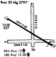
Runways
Runway Summary
| Runways: | 01/19 10/28 |
| Longest Runway: | 10/28 is 4001 ft (1220 m) long |
| Runways with an Instrument Approach: | 10 |
C29 Airport Runway Details
| Runway 01/19 | 1780 ft x 120 ft (543 m x 37 m) | |
| Runway Length Source: | 3RD PARTY SURVEY as of 05/31/2018 | |
| Surface: | Turf - Good condition - No special surface treatment | |
Runway 01 |
Runway 19 |
|
Elevation: |
926.1 | 927.6 |
Latitude: |
43-06-45.9690N | 43-07-03.4028N |
Longitude: |
089-31-42.4271W | 089-31-39.3172W |
|
Runway True Alignment: |
007 | 187 |
Glide Path Angle: |
0.0 degrees | 0.0 degrees |
Runway Markings Type: |
Nonstandard (other than numbers only) | Nonstandard (other than numbers only) |
Runway Markings Condition: |
Fair | Fair |
| Runway 10/28 | 4001 ft x 100 ft (1220 m x 30 m) | |
| Runway Length Source: | 3RD PARTY SURVEY as of 05/31/2018 | |
| Surface: | Turf - Good condition - No special surface treatment | |
| Runway Edge Lights: | Medium Intensity | |
Runway 10 |
Runway 28 |
|
Elevation: |
927.9 | 926.8 |
Latitude: |
43-06-53.5186N | 43-06-46.8984N |
Longitude: |
089-32-26.3327W | 089-31-33.1658W |
|
Runway True Alignment: |
100 | 280 |
ILS Type: |
LOC/DME | |
Glide Path Angle: |
4.0 degrees | 4.0 degrees |
Traffic Pattern: |
Left | |
Runway Markings Type: |
Nonprecision Instrument | Nonprecision Instrument |
Runway Markings Condition: |
Fair | Fair |
Visual Glide Slope Indicators: |
2-Light PAPI On Left Side Of Runway | 2-Light PAPI On Left Side Of Runway |
REIL: |
Yes | Yes |
Threshold Crossing Height: |
31 | 36 |
Services
Airframe Repair: |
None |
Powerplant Repair: |
None |
Bottled Oxygen: |
None |
Bulk Oxygen: |
None |
Fuel Available: |
100LL, Jet A+, MOGAS |
Landing Fees: |
No |
Parking: |
Hangars and tiedowns available |
Maps & Diagrams
C29 Sectional
Flight Planning
at skyvector.com
at skyvector.com