Location
Latitude: |
44-18-16.3000N (44.304528) |
Longitude: |
096-49-08.1000W (-96.818917) |
Elevation: |
1647.5 feet MSL (502 m MSL) |
Magnetic Variation: |
2.7 E (as of April 2024 from WMM2020 model) |
Time Zone: |
UTC -6.0 (Standard Time) UTC -5.0 (Daylight Savings Time) |
From City: |
00 N.M. SW of Brookings, South Dakota |
Found On: |
Omaha Chart |
FAA Region: |
AGL |
Contacts
Manager: |
Publicly owned: |
| LUCAS DAHL 509 W SECOND STREET BROOKINGS, SD 57006 605-697-8664 |
CITY OF BROOKINGS 520 3RD STREET, SUITE 140, PO BOX 270 BROOKINGS, SD 57006 605-692-6955 |
Operations
Airport Status: |
Operational |
Facility Use: |
Public |
Type: |
Airport |
Activation Date: |
11/1949 |
Control tower: |
No |
Attendance (Months/Days/Hours): |
Months/Days/Hours ALL/ALL/0800-1800 |
Boundary ARTCC: |
ZMP (Minneapolis) |
Responsible ARTCC: |
ZMP (Minneapolis) |
Lighting Schedule: |
SEE RMK |
Segmented Circle Indicator: |
No |
Traffic Pattern Altitude (MSL): |
2648 feet (807 m) |
NOTAMs Facility: |
BKX |
NOTAM-D Service: |
Yes |
International Airport of Entry: |
No |
Customs Landing Rights: |
No |
Military Landing Rights: |
Yes |
Civil/Military Joint Use: |
No |
Based Aircraft
| Single Engine: | 54 |
| Multi Engine: | 5 |
| Jet Engine: | 1 |
| Gliders: | 3 |
Annual Operations (as of 12/31/2020)
| Total Operations: | 32025 | |
| Air Taxi: | 425 | 1.3% |
| GA Local: | 31000 | 96.8% |
| GA Itinerant: | 500 | 1.6% |
| Military Aircraft: | 100 | 0.3% |
Communications
| CTAF: | 123.000 |
| Unicom: | 123.000 |
| AWOS-3PT: | 119.925 (605-692-1809) |
- APCH/DEP SVC PRVDD BY MINNEAPOLIS ARTCC (ZMP) ON FREQS 132.05/317.4 (SIOUX FALLS RCAG).
Fixed Based Operators (FBOs) & Fuel
(Click on a business for detail)
Please help us keep this information up to date. This is a FREE SERVICE just like everything else on Airport Guide! If you see that a business needs to be added, modified, or deleted please fill out our Update Form.
To add, modify, or delete a business click here.
Please help us keep this information up to date. This is a FREE SERVICE just like everything else on Airport Guide! If you see that a business needs to be added, modified, or deleted please fill out our Update Form.
Area Code: 605 |
| Business Name | Frequency | Phone | Fuel Grade |
|---|---|---|---|
| Miller Aviation
Update FBO info |
692-9005 | 100LL, Jet A |
Flight Service Stations
| Primary | Alternate | |
| FSS on Field: | N | |
| FSS Name (ID): | Huron(HON) | |
| Frequency: | ||
| Toll Free Phone: | 1-800-WX-BRIEF |
Instrument Procedures / Charts
FAA Terminal Procedures valid from 0901Z 03/21/24 to 0901Z 04/18/24.
There are various types of charts available for an airport. They are listed in the Page Type column. Here is a legend for those types:
APD - Airport Diagram
DP - Departure Procedure Charts
HOT - Hot Spots
IAP - Instrument Approach Procedure Charts
MIN - Minimums
STAR - Standard Terminal Arrival Charts
| Page Type | Page Name | Volume | Action Since Last Cycle |
|---|---|---|---|
| APD | AIRPORT DIAGRAM | NC-1 | |
| IAP | ILS OR LOC RWY 12 | NC-1 | |
| IAP | RNAV (GPS) RWY 12 | NC-1 | |
| IAP | RNAV (GPS) RWY 30 | NC-1 | |
| MIN | ALTERNATE MINIMUMS | NC-1 | |
| MIN | TAKEOFF MINIMUMS | NC-1 |
Terminal Procedures are only available for airports in several countries with more being added all the time. If you are looking for a specific country's charts, please send an email to support(at)airportguide.com stating the country name. This will be used to prioritize the implementation.
Navigation Aids (Navaids) near BKX
| Dist (NM) | ID | Morse Code | Name | Type | Freq | True Hdg | Mag Hdg |
|---|---|---|---|---|---|---|---|
| 0.2 | BKX | _ . . . _ . _ _ . . _ | Brookings | VOR-DME | 108.80 | 115 | 112 |
| 6.3 | BK | _ . . . _ . _ | Chrlz | NDB | 335 | 298 | 295 |
| 21.0 | MDS | _ _ _ . . . . . | Wentworth | NDB | 400 | 213 | 210 |
| 33.1 | AT | . _ _ | Lican | NDB | 215 | 334 | 331 |
| 39.3 | FSD | . . _ . . . . _ . . | Sioux Falls | VORTAC | 115.00 | 177 | 174 |
| 40.7 | GB | _ _ . _ . . . | Garno | NDB | 253 | 72 | 70 |
| 42.8 | ATY | . _ _ _ . _ _ | Watertown | TACAN | 116.60 | 341 | 338 |
| 43.5 | MML | _ _ _ _ . _ . . | Marshall | VOR-DME | 111.00 | 78 | 76 |
| 48.6 | FS | . . _ . . . . | Rokky | NDB | 245 | 180 | 177 |
| 49.1 | DXX | _ . . _ . . _ _ . . _ | Dawson/Madison | NDB | 341 | 33 | 31 |
| 61.4 | MHE | _ _ . . . . . | Mitchell | VOR-DME | 109.20 | 239 | 236 |
| 62.0 | MVE | _ _ . . . _ . | Montevideo | VOR-DME | 111.60 | 49 | 47 |
| 62.2 | VVV | . . . _ . . . _ . . . _ | Ortonville | NDB | 332 | 15 | 12 |
| 64.5 | HON | . . . . _ _ _ _ . | Huron | DME | 117.6 | 277 | 274 |
| 65.3 | AQP | . _ _ _ . _ . _ _ . | Appleton | NDB | 356 | 31 | 29 |
| 65.6 | HO | . . . . _ _ _ | Beady | NDB | 302 | 277 | 274 |
| 66.4 | OTG | _ _ _ _ _ _ . | Worthington | DME | 110.6 | 126 | 124 |
| 71.6 | OT | _ _ _ _ | Wondd | NDB | 277 | 124 | 122 |
| 72.7 | ISB | . . . . . _ . . . | Sibley | NDB | 269 | 140 | 138 |
| 73.1 | RWF | . _ . . _ _ . . _ . | Redwood Falls | VOR-DME | 113.30 | 81 | 79 |
Nearby Airports with Fuel
Notices to Airmen (NOTAMS)
Remarks
| A110-1 | INTENSIVE STUDENT TRAINING. |
| A110-10 | FOR CD IF UNA TO CTC ON FSS FREQ, CTC MINNEAPOLIS ARTCC AT 651-463-5588. |
| A110-11 | AIRFIELD CONDS NOT MNTD BTN 1900 - 0700 HRS LCL TIME. |
| A110-12 | RWY 30 IS PREFERRED RWY WHEN WNDS ARE CALM. |
| A110-2 | LARGE FLOCKS OF GEESE & GULLS ON & INVOF ARPT APR THRU OCT. |
| A110-8 | FOR ATTENDANT AFT HRS CALL 605-692-2779 OR 605-690-6013. |
| A110-9 | GCO AVBL ON FREQ 121.725 (4 CLICKS TO MINNEAPOLIS CENTER, 6 CLICKS TO FLT SVC) |
| A81-APT | ACTVT MALSR RWY 12; REIL RWY 17, 30, 35; PAPI RWY 12, 17, 30, 35; HIRL RWY 12/30; MIRL RWY 17/35 - CTAF |
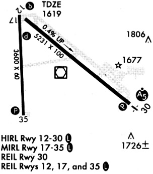
Runways
Runway Summary
| Runways: | 12/30 17/35 |
| Longest Runway: | 12/30 is 6000 ft (1829 m) long |
| Runways with an Instrument Approach: | 12 |
BKX Airport Runway Details
| Runway 12/30 | 6000 ft x 100 ft (1829 m x 30 m) | |
| Runway Length Source: | AVN as of 08/05/2014 | |
| Surface: | Asphalt - Excellent condition - Saw-cut or plastic grooved | |
| Runway Pavement Class: | 39 /F/D/X/T | |
| Runway Edge Lights: | High Intensity | |
Runway Weight Bearing Capacity (in thousands of pounds) |
||
| Single Wheel Landing Gear: | 44.0 | |
| Dual Wheel Landing Gear: | 61.0 | |
| Dual Tandem Wheel Landing Gear: | 86.0 | |
Runway 12 |
Runway 30 |
|
Elevation: |
1602.6 | 1636.7 |
Latitude: |
44-18-29.0899N | 44-18-00.8030N |
Longitude: |
096-49-39.0191W | 096-48-26.5242W |
|
Runway True Alignment: |
119 | 299 |
ILS Type: |
ILS/DME | |
Glide Path Angle: |
3.0 degrees | 3.0 degrees |
Traffic Pattern: |
Left | Left |
Runway Markings Type: |
Precision Instrument | Precision Instrument |
Runway Markings Condition: |
Good | Good |
Visual Glide Slope Indicators: |
4-Light PAPI On Left Side Of Runway | 4-Light PAPI On Left Side Of Runway |
Approach Light System: |
1,400 Foot Medium Intensity Approach Lighting System With Runway Alignment Indicator Lights | |
REIL: |
Yes | |
Touchdown Lights: |
No | No |
Centerline Lights: |
No | No |
Threshold Crossing Height: |
50 | 35 |
Declared Distances |
||
Take Off Run Avbl. (TORA): |
6000 | 6000 |
Take Off Distance Avbl. (TODA): |
6000 | 6000 |
Actual Stop Dist. Avbl. (ASDA): |
6000 | 6000 |
Landing Dist. Avbl. (LDA): |
6000 | 6000 |
| Runway 17/35 | 3600 ft x 60 ft (1097 m x 18 m) | |
| Runway Length Source: | AVN as of 08/05/2014 | |
| Surface: | Asphalt - Excellent condition - No special surface treatment | |
| Runway Pavement Class: | 27 /F/D/X/T | |
| Runway Edge Lights: | Medium Intensity | |
Runway Weight Bearing Capacity (in thousands of pounds) |
||
| Single Wheel Landing Gear: | 12.5 | |
Runway 17 |
Runway 35 |
|
Elevation: |
1609.8 | 1645.9 |
Latitude: |
44-18-36.3650N | 44-18-00.8690N |
Longitude: |
096-49-18.2865W | 096-49-15.5960W |
|
Runway True Alignment: |
177 | 357 |
Glide Path Angle: |
3.0 degrees | 3.0 degrees |
Runway Markings Type: |
Nonprecision Instrument | Nonprecision Instrument |
Runway Markings Condition: |
Good | Good |
Visual Glide Slope Indicators: |
2-Light PAPI On Left Side Of Runway | 2-Light PAPI On Left Side Of Runway |
REIL: |
Yes | Yes |
Threshold Crossing Height: |
25 | 24 |
Declared Distances |
||
Take Off Run Avbl. (TORA): |
3600 | 3600 |
Take Off Distance Avbl. (TODA): |
3600 | 3600 |
Actual Stop Dist. Avbl. (ASDA): |
3600 | 3600 |
Landing Dist. Avbl. (LDA): |
3600 | 3600 |
Services
Airframe Repair: |
Major |
Powerplant Repair: |
Major |
Bottled Oxygen: |
None |
Bulk Oxygen: |
None |
Fuel Available: |
100LL, Jet A |
Landing Fees: |
No |
Parking: |
Hangars and tiedowns available |
Maps & Diagrams
BKX Sectional
Flight Planning
at skyvector.com
at skyvector.com