
Location
Latitude: |
41-17-49.56N (41.2971) |
Longitude: |
002-04-42.456E (2.07846) |
Elevation: |
12 feet MSL (4 m MSL) |
Magnetic Variation: |
1.8 E (as of April 2024 from WMM2020 model) |
Time Zone: |
UTC +1.0 (Standard Time) UTC +2.0 (Daylight Savings Time) |
Contacts
Manager: |
: |
Operations
Airport Status: |
Operational |
Facility Use: |
Public |
Type: |
Airport |
Traffic Pattern Altitude (MSL): |
1012 feet (308 m) |
Based Aircraft
Annual Operations (as of )
Communications
| TWR: | 118.1 |
| CLNC DEL: | 121.8 |
| GND: | 121.65 |
| APP: | 119.1 |
| ATIS: | 118.65 |
Fixed Based Operators (FBOs) & Fuel
(Click on a business for detail)
Please help us keep this information up to date. This is a FREE SERVICE just like everything else on Airport Guide! If you see that a business needs to be added, modified, or deleted please fill out our Update Form.
To add, modify, or delete a business click here.
Please help us keep this information up to date. This is a FREE SERVICE just like everything else on Airport Guide! If you see that a business needs to be added, modified, or deleted please fill out our Update Form.
| Business Name | Frequency | Phone | Fuel Grade |
|---|
Flight Service Stations
| Primary | Alternate | |
| FSS on Field: | ||
| FSS Name (ID): | ||
| Frequency: | ||
| Toll Free Phone: |
Instrument Procedures / Charts
Terminal Procedures are only available for airports in several countries with more being added all the time. If you are looking for a specific country's charts, please send an email to support(at)airportguide.com stating the country name. This will be used to prioritize the implementation.
Navigation Aids (Navaids) near BCN
| Dist (NM) | ID | Morse Code | Name | Type | Freq | True Hdg | Mag Hdg |
|---|---|---|---|---|---|---|---|
| 0.9 | PRA | El Prat | VOR-DME | 114.30 | 169 | 167 | |
| 1.5 | BCN | Barcelona | VOR-DME | 116.70 | 65 | 63 | |
| 13.4 | SBD | Sabadell | NDB | 367 | 4 | 2 | |
| 13.4 | SLL | Sabadell | VOR-DME | 112.00 | 6 | 4 | |
| 17.6 | VNV | Villanueva | NDB | 380 | 252 | 250 | |
| 24.1 | VLA | Villafranca | VOR-DME | 113.15 | 276 | 274 | |
| 32.4 | CLE | Calella | VOR-DME | 115.35 | 50 | 48 | |
| 41.9 | RES | Reus | VOR-DME | 114.20 | 258 | 256 | |
| 43.0 | RUS | Reus | NDB | 424 | 258 | 256 | |
| 49.1 | GIR | Gerona | VOR-DME | 114.10 | 39 | 37 | |
| 54.5 | GRN | Gerona | NDB | 412 | 36 | 34 | |
| 63.7 | SEO | Seo De Urgel | NDB | 340 | 331 | 329 | |
| 63.9 | BAG | Bagur | NDB | 319 | 51 | 49 | |
| 64.0 | BGR | Bagur | VOR-DME | 112.20 | 52 | 50 | |
| 66.2 | LRD | Lerida | NDB | 404 | 283 | 281 | |
| 86.9 | MLA | Maella | VOR-DME | 112.10 | 263 | 261 | |
| 94.0 | PPG | Perpignan | VOR-DME | 116.25 | 21 | 19 | |
| 94.8 | POS | Pollensa | VOR-DME | 116.40 | 149 | 147 |
Nearby Airports with Fuel
| Dist (NM) | Name (Airport IDs) | True Hdg | Mag Hdg | Fuel Grade |
|---|
Notices to Airmen (NOTAMS)
Remarks
No remarks for this landing facility
Runways
Runway Summary
| Runways: | 02/20 06L/24R 06R/24L |
| Longest Runway: | 06L/24R is 10997 ft (3352 m) long |
| Runways with an Instrument Approach: |
BCN Airport Runway Details
| Runway 02/20 | 8294 ft x 147 ft (2528 m x 45 m) | |
| Runway Edge Lights: | Yes Intensity | |
Runway 02 |
Runway 20 |
|
Elevation: |
7 | 12 |
Latitude: |
41.28779983520 | 41.30939865112 |
Longitude: |
2.0848400592803 | 2.0947101116180 |
|
Runway True Alignment: |
19 | 199 |
Glide Path Angle: |
0.0 degrees | 0.0 degrees |
REIL: |
Yes | Yes |
Threshold Elevation: |
7 | 12 |
Displaced Threshold: |
131 |
| Runway 06L/24R | 10997 ft x 196 ft (3352 m x 60 m) | |
| Runway Edge Lights: | Yes Intensity | |
Runway 06L |
Runway 24R |
|
Elevation: |
8 | 10 |
Latitude: |
41.2925 | 41.305698 |
Longitude: |
2.06511 | 2.10373 |
|
Runway True Alignment: |
66 | 246 |
Glide Path Angle: |
0.0 degrees | 0.0 degrees |
REIL: |
Yes | Yes |
Threshold Elevation: |
8 | 10 |
Displaced Threshold: |
295 |
| Runway 06R/24L | 8727 ft x 196 ft (2660 m x 60 m) | |
| Runway Edge Lights: | Yes Intensity | |
Runway 06R |
Runway 24L |
|
Elevation: |
8 | 8 |
Latitude: |
41.282299 | 41.292198 |
Longitude: |
2.07435 | 2.10328 |
|
Runway True Alignment: |
66 | 246 |
Glide Path Angle: |
0.0 degrees | 0.0 degrees |
REIL: |
Yes | Yes |
Threshold Elevation: |
8 | 8 |
Services
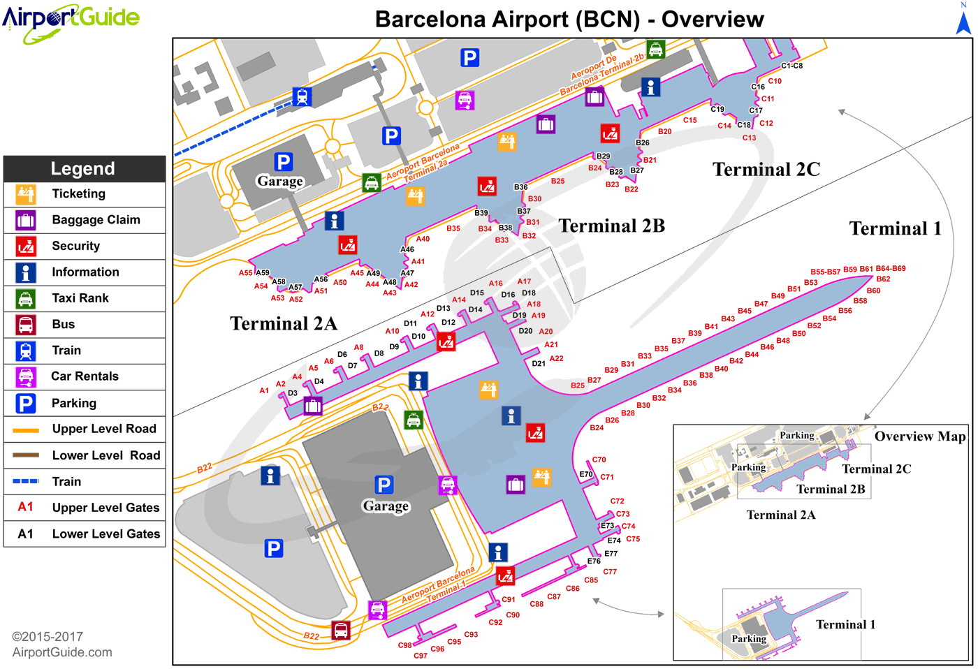
Maps & Diagrams
BCN Sectional
Flight Planning
at skyvector.com
at skyvector.com
