Location
Latitude: |
37-12-33.7920N (37.209387) |
Longitude: |
080-24-43.5240W (-80.41209) |
Elevation: |
2119.5 feet MSL (646 m MSL) |
Magnetic Variation: |
8.5 W (as of April 2024 from WMM2020 model) |
Time Zone: |
UTC -5.0 (Standard Time) UTC -4.0 (Daylight Savings Time) |
From City: |
03 N.M. S of Blacksburg, Virginia |
Found On: |
Cincinnati Chart |
FAA Region: |
AEA |
Contacts
Manager: |
Publicly owned: |
| KEITH HOLT 1601 RESEARCH CENTER DRIVE BLACKSBURG, VA 24060 540-231-4444 |
VTMRAA 1601 RESEARCH CENTER DRIVE BLACKSBURG, VA 24060 540-231-4444 |
Operations
Airport Status: |
Operational |
Facility Use: |
Public |
Type: |
Airport |
Activation Date: |
08/1937 |
Control tower: |
No |
Attendance (Months/Days/Hours): |
Months/Days/Hours APR - OCT/ALL/0800-1900 |
Boundary ARTCC: |
ZDC (Washington) |
Responsible ARTCC: |
ZDC (Washington) |
Lighting Schedule: |
SEE RMK |
Segmented Circle Indicator: |
Yes |
Traffic Pattern Altitude (MSL): |
3120 feet (951 m) |
NOTAMs Facility: |
BCB |
NOTAM-D Service: |
Yes |
International Airport of Entry: |
No |
Customs Landing Rights: |
No |
Military Landing Rights: |
Yes |
Civil/Military Joint Use: |
No |
Based Aircraft
| Single Engine: | 37 |
| Multi Engine: | 1 |
| Jet Engine: | 3 |
| GA Helicopters: | 1 |
Annual Operations (as of 06/28/2019)
| Total Operations: | 21900 | |
| Air Taxi: | 423 | 1.9% |
| GA Local: | 6700 | 30.6% |
| GA Itinerant: | 14425 | 65.9% |
| Military Aircraft: | 352 | 1.6% |
Communications
| CTAF: | 123.050 |
| Unicom: | 123.050 |
| Clearance Del.: | 124.85 124.85 124.85 |
| Approach: | ROANOKE |
| Departure: | ROANOKE |
| AWOS-3: | 133.325 (540-231-4837) |
Fixed Based Operators (FBOs) & Fuel
(Click on a business for detail)
Please help us keep this information up to date. This is a FREE SERVICE just like everything else on Airport Guide! If you see that a business needs to be added, modified, or deleted please fill out our Update Form.
To add, modify, or delete a business click here.
Please help us keep this information up to date. This is a FREE SERVICE just like everything else on Airport Guide! If you see that a business needs to be added, modified, or deleted please fill out our Update Form.
Area Code: 540 |
| Business Name | Frequency | Phone | Fuel Grade |
|---|---|---|---|
| Hokie Flying Club
Website Update FBO info |
|||
| Virginia Tech Airport
Update FBO info |
Unicom 123.05 | 231-4444 | 100LL, Jet A |
Flight Service Stations
| Primary | Alternate | |
| FSS on Field: | N | |
| FSS Name (ID): | Leesburg(DCA) | |
| Frequency: | ||
| Toll Free Phone: | 1-800-WX-BRIEF |
Instrument Procedures / Charts
FAA Terminal Procedures valid from 0901Z 03/21/24 to 0901Z 04/18/24.
There are various types of charts available for an airport. They are listed in the Page Type column. Here is a legend for those types:
APD - Airport Diagram
DP - Departure Procedure Charts
HOT - Hot Spots
IAP - Instrument Approach Procedure Charts
MIN - Minimums
STAR - Standard Terminal Arrival Charts
| Page Type | Page Name | Volume | Action Since Last Cycle |
|---|---|---|---|
| DP | BEMAR THREE (RNAV) | NE-3 | |
| DP | SETHY FIVE (RNAV) | NE-3 | |
| IAP | LOC RWY 13 | NE-3 | |
| IAP | RNAV (GPS) RWY 13 | NE-3 | |
| IAP | RNAV (GPS) RWY 31 | NE-3 | |
| MIN | ALTERNATE MINIMUMS | NE-3 | |
| MIN | TAKEOFF MINIMUMS | NE-3 |
Terminal Procedures are only available for airports in several countries with more being added all the time. If you are looking for a specific country's charts, please send an email to support(at)airportguide.com stating the country name. This will be used to prioritize the implementation.
Navigation Aids (Navaids) near BCB
| Dist (NM) | ID | Morse Code | Name | Type | Freq | True Hdg | Mag Hdg |
|---|---|---|---|---|---|---|---|
| 0.4 | TEC | _ . _ . _ . | Tech | NDB | 368 | 96 | 105 |
| 16.1 | PSK | . _ _ . . . . _ . _ | Pulaski | VORTAC | 116.80 | 243 | 251 |
| 18.2 | ROA | . _ . _ _ _ . _ | Roanoke | VOR-DME | 109.40 | 63 | 72 |
| 21.8 | ODR | _ _ _ _ . . . _ . | Woodrum | VOR | 114.90 | 71 | 80 |
| 25.4 | VIT | . . . _ . . _ | Vinton | NDB | 277 | 90 | 99 |
| 33.3 | HLX | . . . . . _ . . _ . . _ | Hillsville | NDB | 269 | 216 | 224 |
| 34.5 | LW | . _ . . . _ _ | Bushi | NDB | 346 | 355 | 364 |
| 37.8 | BLF | _ . . . . _ . . . . _ . | Bluefield | VOR-DME | 115.05 | 279 | 287 |
| 39.3 | LWB | . _ . . . _ _ _ . . . | Greenbrier | DME | 116.05 | 1 | 10 |
| 43.4 | MKJ | _ _ _ . _ . _ _ _ | Suzze | NDB | 335 | 246 | 254 |
| 44.1 | UV | . . _ . . . _ | Bales | NDB | 396 | 147 | 156 |
| 48.2 | BKW | _ . . . _ . _ . _ _ | Beckley | VOR-DME | 117.70 | 315 | 323 |
| 49.6 | RNL | . _ . _ . . _ . . | Rainelle | VOR | 116.60 | 337 | 345 |
| 50.1 | AZW | . _ _ _ . . . _ _ | Mount Airy | NDB | 223 | 187 | 195 |
| 54.7 | OQA | _ _ _ _ _ . _ . _ | Rockingham County | FAN MARKER | 149 | 158 | |
| 55.9 | LY | . _ . . _ . _ _ | Bojar | NDB | 385 | 86 | 95 |
| 56.0 | ZEF | _ _ . . . . . _ . | Zephyr | NDB | 326 | 195 | 203 |
| 56.2 | LYH | . _ . . _ . _ _ . . . . | Lynchburg | VOR-DME | 109.20 | 86 | 95 |
| 58.6 | SIF | . . . . . . . _ . | Slammer | NDB | 423 | 147 | 156 |
| 63.8 | JUH | . _ _ _ . . _ . . . . | Ashee | NDB | 410 | 223 | 231 |
Nearby Airports with Fuel
Notices to Airmen (NOTAMS)
Remarks
| A110-1 | OCCASIONAL WILDLIFE ON ARPT. |
| A110-3 | VFR DEPARTURES MAINTAIN RWY HEADING UNTIL REACHING 1000 FT AGL. |
| A110-4 | NOISE SENSITIVE AREA NORTH OF ARPT. |
| A110-5 | ROA TWR SVCS AVBL AT 540-563-1307. |
| A110-6 | FOR CD CTC ROANOKE APCH AT 540-563-1307. |
| A17 | UNATNDD NEW YEAR'S DAY, THANKSGIVING DAY, CHRISTMAS DAY, MAJOR HOLIDAYS. |
| A70-FUEL-10 | 0LL PPR FOR FUEL WHEN ARPT UNATNDD; PHONE 540-231-4444; FEE FOR AFT HRS. |
| A81-APT | ACTVT ODALS RWY 13; REIL RWY 31; PAPI RWY 13 & 31; MIRL RWY 13/31 - CTAF. MIRL RWY 13/31 PRESET LOW INTST. |
| E147 | TPA 1000 FT AGL FOR NON TURBINE POWERED ACFT. TPA FOR TURBINE POWERED ACFT 1500 FT AGL. |
Runways
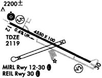
Runway Summary
| Runways: | 13/31 |
| Longest Runway: | 13/31 is 5501 ft (1677 m) long |
| Runways with an Instrument Approach: | 13 |
BCB Airport Runway Details
| Runway 13/31 | 5501 ft x 100 ft (1677 m x 30 m) | |
| Runway Length Source: | 3RD PARTY SURVEY as of 08/25/2015 | |
| Surface: | Asphalt - Fair condition - Saw-cut or plastic grooved | |
| Runway Edge Lights: | Medium Intensity | |
Runway 13 |
Runway 31 |
|
Elevation: |
2119.2 | 2119.5 |
Latitude: |
37-12-46.2105N | 37-12-21.3707N |
Longitude: |
080-25-13.7670W | 080-24-13.2833W |
|
Runway True Alignment: |
117 | 297 |
ILS Type: |
LOC/DME | |
Glide Path Angle: |
3.4 degrees | 3.0 degrees |
Traffic Pattern: |
Left | |
Runway Markings Type: |
Nonprecision Instrument | Nonprecision Instrument |
Runway Markings Condition: |
Good | Good |
Object at End: |
SIGN | BRUSH |
Object Height: |
31 | 70 |
Distance from End: |
1114 | 2170 |
Object Centerline Offset: |
359 ft. left of centerline | 498 ft. right of centerline |
Visual Glide Slope Indicators: |
4-Light PAPI On Left Side Of Runway | 2-Light PAPI On Left Side Of Runway |
Approach Light System: |
Omnidirectional Approach Lighting System | |
REIL: |
No | Yes |
Threshold Crossing Height: |
55 | 50 |
Services
Airframe Repair: |
Major |
Powerplant Repair: |
Major |
Bottled Oxygen: |
High Pressure |
Bulk Oxygen: |
None |
Fuel Available: |
100LL, Jet A-1+ |
Landing Fees: |
No |
Parking: |
Hangars and tiedowns available |
Maps & Diagrams
BCB Sectional
Flight Planning
at skyvector.com
at skyvector.com