Location
Latitude: |
40-35-56.6000N (40.599056) |
Longitude: |
116-52-27.6000W (-116.874333) |
Elevation: |
4536.1 feet MSL (1383 m MSL) |
Magnetic Variation: |
12.5 E (as of April 2024 from WMM2020 model) |
Time Zone: |
UTC -8.0 (Standard Time) UTC -7.0 (Daylight Savings Time) |
From City: |
03 N.M. SE of Battle Mountain, Nevada |
Found On: |
Salt Lake City Chart |
FAA Region: |
AWP |
Contacts
Manager: |
Publicly owned: |
| BERT RAMOS 50 STATE ROUTE 305 BATTLE MOUNTAIN, NV 89820 775-455-6860 |
LANDER COUNTY 50 STATE ROUTE 305 BATTLE MOUNTAIN, NV 89820 775-635-2885 |
Operations
Airport Status: |
Operational |
Facility Use: |
Public |
Type: |
Airport |
Activation Date: |
02/1944 |
Control tower: |
No |
Attendance (Months/Days/Hours): |
Months/Days/Hours OCT-MAY/ALL/0700-1700 |
Boundary ARTCC: |
ZLC (Salt Lake City) |
Responsible ARTCC: |
ZLC (Salt Lake City) |
Lighting Schedule: |
SEE RMK |
Segmented Circle Indicator: |
Yes |
Traffic Pattern Altitude (MSL): |
5536 feet (1687 m) |
NOTAMs Facility: |
RNO |
NOTAM-D Service: |
Yes |
International Airport of Entry: |
No |
Customs Landing Rights: |
No |
Military Landing Rights: |
Yes |
Civil/Military Joint Use: |
No |
Based Aircraft
| Single Engine: | 10 |
Annual Operations (as of 09/30/2021)
| Total Operations: | 4200 | |
| Air Taxi: | 800 | 19.0% |
| GA Local: | 1240 | 29.5% |
| GA Itinerant: | 1800 | 42.9% |
| Military Aircraft: | 360 | 8.6% |
Communications
| CTAF: | 122.800 |
| Unicom: | 122.800 |
| AWOS-3: | 119.45 (775-635-8419) |
- APCH/DEP CTL SVC PRVDD BY SALT LAKE ARTCC (ZLC) ON FREQS 132.25/338.35 (BATTLE MOUNTAIN RCAG).
- COMMUNICATIONS PRVDD BY RENO RADIO ON FREQ 122.65 (BATTLE MOUNTAIN RCO).
Fixed Based Operators (FBOs) & Fuel
(Click on a business for detail)
Please help us keep this information up to date. This is a FREE SERVICE just like everything else on Airport Guide! If you see that a business needs to be added, modified, or deleted please fill out our Update Form.
To add, modify, or delete a business click here.
Please help us keep this information up to date. This is a FREE SERVICE just like everything else on Airport Guide! If you see that a business needs to be added, modified, or deleted please fill out our Update Form.
Area Code: 775 |
| Business Name | Frequency | Phone | Fuel Grade |
|---|---|---|---|
| Harless Aircraft Service
Update FBO info |
Unicom 122.8 | 635-2245 | 100LL, Jet A |
Flight Service Stations
| Primary | Alternate | |
| FSS on Field: | N | |
| FSS Name (ID): | Reno(RNO) | |
| Frequency: | ||
| Toll Free Phone: | 1-800-WX-BRIEF |
Instrument Procedures / Charts
FAA Terminal Procedures valid from 0901Z 03/21/24 to 0901Z 04/18/24.
There are various types of charts available for an airport. They are listed in the Page Type column. Here is a legend for those types:
APD - Airport Diagram
DP - Departure Procedure Charts
HOT - Hot Spots
IAP - Instrument Approach Procedure Charts
MIN - Minimums
STAR - Standard Terminal Arrival Charts
| Page Type | Page Name | Volume | Action Since Last Cycle |
|---|---|---|---|
| APD | AIRPORT DIAGRAM | SW-4 | |
| IAP | RNAV (GPS) RWY 04 | SW-4 | |
| IAP | RNAV (GPS) RWY 22 | SW-4 | |
| IAP | VOR RWY 04 | SW-4 | |
| MIN | ALTERNATE MINIMUMS | SW-4 | |
| MIN | TAKEOFF MINIMUMS | SW-4 |
Terminal Procedures are only available for airports in several countries with more being added all the time. If you are looking for a specific country's charts, please send an email to support(at)airportguide.com stating the country name. This will be used to prioritize the implementation.
Navigation Aids (Navaids) near BAM
| Dist (NM) | ID | Morse Code | Name | Type | Freq | True Hdg | Mag Hdg |
|---|---|---|---|---|---|---|---|
| 2.8 | BAM | _ . . . . _ _ _ | Battle Mountain | VORTAC | 112.20 | 230 | 218 |
| 46.0 | UUC | . . _ . . _ _ . _ . | Winnie | DME | 113.75 | 293 | 280 |
| 46.3 | INA | . . _ . . _ | Winnemucca | VOR-DME | 108.20 | 293 | 280 |
| 51.5 | BQU | _ . . . _ _ . _ . . _ | Bullion | VOR-DME | 115.85 | 78 | 66 |
| 71.5 | SDO | . . . _ . . _ _ _ | Sod House | VORTAC | 111.45 | 313 | 300 |
| 82.9 | LLC | . _ . . . _ . . _ . _ . | Lovelock | VORTAC | 116.50 | 250 | 237 |
| 92.1 | LWL | . _ . . . _ _ . _ . . | Wells | VOR-DME | 114.65 | 68 | 56 |
| 92.9 | RMD | . _ . _ _ _ . . | Mc Dermitt State | NDB | 204 | 336 | 323 |
Nearby Airports with Fuel
| Dist (NM) | Name (Airport IDs) | True Hdg | Mag Hdg | Fuel Grade |
|---|---|---|---|---|
| 46.0 | Winnemucca Municipal Airport (WMC KWMC WMC) |
293 | 280 | 100LL, Jet A |
| 51.1 | Elko Regional Airport (EKO KEKO EKO) |
74 | 62 | 100LL, Jet A |
| 71.9 | Eureka Airport (EUE 05U) |
145 | 133 | 100LL, Jet A, Jet A+ |
| 83.7 | Derby Field Airport (LOL KLOL LOL) |
248 | 235 | 100LL |
| 93.9 | Wells Municipal/Harriet Field Airport (LWL KLWL LWL) |
70 | 58 | 100LL, Jet A |
Notices to Airmen (NOTAMS)
Remarks
| A110-1 | (E81) EDGE REFLECTORS ON TWYS AND RAMP. |
| A110-2 | FOR CD IF UNA TO CTC ON FSS FREQ, CTC SALT LAKE ARTCC AT 801-320-2568. |
| A17 | AFT HRS CALL (775) 635-2245. |
| A39-04/22 | PCR VALUE: 63/F/C/W/T |
| A39-13/31 | PCR VALUE: 63/F/C/W/T |
| A42-04 | RWY NRS FADED. |
| A42-13 | THR MARKINGS FADED. |
| A42-22 | RWY NRS FADED. |
| A42-31 | THR MARKINGS FADED. |
| A81-APT | ACTVT PAPI RWY 22; MIRL RWYS 04/22 & 13/31; PERI LGTS H1 - CTAF. |
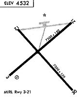
Runways
Runway Summary
| Runways: | 04/22 13/31 H1 H2 |
| Longest Runway: | 04/22 is 7300 ft (2225 m) long |
| Runways with an Instrument Approach: |
BAM Airport Runway Details
| Runway 04/22 | 7300 ft x 150 ft (2225 m x 46 m) | |
| Runway Length Source: | 3RD PARTY SURVEY as of 03/18/2014 | |
| Surface: | Asphalt - Good condition - No special surface treatment | |
| Runway Edge Lights: | Medium Intensity | |
Runway Weight Bearing Capacity (in thousands of pounds) |
||
| Single Wheel Landing Gear: | 30.0 | |
| Dual Wheel Landing Gear: | 125.0 | |
Runway 04 |
Runway 22 |
|
Elevation: |
4535.6 | 4531.3 |
Latitude: |
40-35-37.8119N | 40-36-25.0439N |
Longitude: |
116-53-05.9077W | 116-51-54.4060W |
|
Runway True Alignment: |
049 | 229 |
Glide Path Angle: |
3.0 degrees | 3.0 degrees |
Traffic Pattern: |
Left | Left |
Runway Markings Type: |
Nonprecision Instrument | Nonprecision Instrument |
Runway Markings Condition: |
Fair | Fair |
Visual Glide Slope Indicators: |
2-Box VASI On Right Side Of Runway | 4-Light PAPI On Left Side Of Runway |
REIL: |
No | No |
Touchdown Lights: |
No | No |
Centerline Lights: |
No | No |
Threshold Crossing Height: |
26 | 45 |
| Runway 13/31 | 7299 ft x 100 ft (2225 m x 30 m) | |
| Runway Length Source: | 3RD PARTY SURVEY as of 03/18/2014 | |
| Surface: | Asphalt - Good condition - No special surface treatment | |
| Runway Edge Lights: | Medium Intensity | |
Runway Weight Bearing Capacity (in thousands of pounds) |
||
| Single Wheel Landing Gear: | 30.0 | |
| Dual Wheel Landing Gear: | 104.0 | |
Runway 13 |
Runway 31 |
|
Elevation: |
4535.9 | 4535.4 |
Latitude: |
40-36-18.9690N | 40-35-24.4751N |
Longitude: |
116-52-56.0775W | 116-51-54.1309W |
|
Runway True Alignment: |
139 | 319 |
Glide Path Angle: |
0.0 degrees | 0.0 degrees |
Traffic Pattern: |
Left | Left |
Runway Markings Type: |
Basic | Basic |
Runway Markings Condition: |
Poor | Poor |
REIL: |
No | No |
Touchdown Lights: |
No | No |
Centerline Lights: |
No | No |
| Helipad H1 | 60 ft x 60 ft (18 m x 18 m) | |
| Surface: | Asphalt - Good condition - No special surface treatment | |
| Runway Edge Lights: | Perimeter lights (for helipads) Intensity | |
Helipad H1 |
||
Glide Path Angle: |
0.0 degrees | 0.0 degrees |
| Helipad H2 | 60 ft x 60 ft (18 m x 18 m) | |
| Surface: | Asphalt - Good condition - No special surface treatment | |
Helipad H2 |
||
Glide Path Angle: |
0.0 degrees | 0.0 degrees |
Services
Bottled Oxygen: |
None |
Bulk Oxygen: |
None |
Fuel Available: |
100LL, Jet A |
Landing Fees: |
No |
Parking: |
Tiedowns available |
Maps & Diagrams
BAM Sectional
Flight Planning
at skyvector.com
at skyvector.com