Location
Latitude: |
39-12-42.8142N (39.211893) |
Longitude: |
082-13-45.3195W (-82.229255) |
Elevation: |
765.7 feet MSL (233 m MSL) |
Magnetic Variation: |
7.6 W (as of April 2024 from WMM2020 model) |
Time Zone: |
UTC -5.0 (Standard Time) UTC -4.0 (Daylight Savings Time) |
From City: |
10 N.M. SW of Athens/Albany, Ohio |
Found On: |
Cincinnati Chart |
FAA Region: |
AGL |
Contacts
Manager: |
Publicly owned: |
| VICKI SMITH 747 COLUMBIA ROAD ALBANY, OH 45710 740-597-2602 |
OHIO UNIVERSITY 747 COLUMBIA ROAD ALBANY, OH 45710 740-597-2600 |
Operations
Airport Status: |
Operational |
Facility Use: |
Public |
Type: |
Airport |
Control tower: |
No |
Attendance (Months/Days/Hours): |
Months/Days/Hours ALL/ALL/ALL |
Boundary ARTCC: |
ZID (Indianapolis) |
Responsible ARTCC: |
ZID (Indianapolis) |
Lighting Schedule: |
SEE RMK |
Segmented Circle Indicator: |
No |
Traffic Pattern Altitude (MSL): |
1766 feet (538 m) |
NOTAMs Facility: |
DAY |
NOTAM-D Service: |
Yes |
International Airport of Entry: |
No |
Customs Landing Rights: |
No |
Military Landing Rights: |
Yes |
Civil/Military Joint Use: |
No |
Based Aircraft
| Single Engine: | 32 |
| Multi Engine: | 6 |
| Jet Engine: | 1 |
Annual Operations (as of 10/05/2021)
| Total Operations: | 110372 | |
| Air Taxi: | 800 | 0.7% |
| GA Local: | 58400 | 52.9% |
| GA Itinerant: | 51100 | 46.3% |
| Military Aircraft: | 72 | 0.1% |
Communications
| CTAF: | 123.075 |
| Unicom: | 123.075 |
| Approach: | HUNTINGTON 120.95 120.95 120.95 |
| Departure: | HUNTINGTON 120.95 120.95 120.95 |
| AWOS-3: | 128.325 (740-597-2687) |
Fixed Based Operators (FBOs) & Fuel
(Click on a business for detail)
Please help us keep this information up to date. This is a FREE SERVICE just like everything else on Airport Guide! If you see that a business needs to be added, modified, or deleted please fill out our Update Form.
To add, modify, or delete a business click here.
Please help us keep this information up to date. This is a FREE SERVICE just like everything else on Airport Guide! If you see that a business needs to be added, modified, or deleted please fill out our Update Form.
Area Code: 740 |
| Business Name | Frequency | Phone | Fuel Grade |
|---|---|---|---|
| Ohio University Airport
Update FBO info |
Unicom 123.0 | 597-2600 | 100LL, Jet A |
Flight Service Stations
| Primary | Alternate | |
| FSS on Field: | N | |
| FSS Name (ID): | Dayton(DAY) | |
| Frequency: | ||
| Toll Free Phone: | 1-800-WX-BRIEF |
Instrument Procedures / Charts
FAA Terminal Procedures valid from 0901Z 03/21/24 to 0901Z 04/18/24.
There are various types of charts available for an airport. They are listed in the Page Type column. Here is a legend for those types:
APD - Airport Diagram
DP - Departure Procedure Charts
HOT - Hot Spots
IAP - Instrument Approach Procedure Charts
MIN - Minimums
STAR - Standard Terminal Arrival Charts
| Page Type | Page Name | Volume | Action Since Last Cycle |
|---|---|---|---|
| IAP | ILS OR LOC RWY 25 | EC-2 | |
| IAP | NDB RWY 25 | EC-2 | |
| IAP | RNAV (GPS) RWY 07 | EC-2 | |
| IAP | RNAV (GPS) RWY 25 | EC-2 | |
| MIN | ALTERNATE MINIMUMS | EC-2 | |
| MIN | TAKEOFF MINIMUMS | EC-2 |
Terminal Procedures are only available for airports in several countries with more being added all the time. If you are looking for a specific country's charts, please send an email to support(at)airportguide.com stating the country name. This will be used to prioritize the implementation.
Navigation Aids (Navaids) near ATO
| Dist (NM) | ID | Morse Code | Name | Type | Freq | True Hdg | Mag Hdg |
|---|---|---|---|---|---|---|---|
| 1.8 | UNI | . . _ _ . . . | Athens | FAN MARKER | 61 | 69 | |
| 5.5 | UGS | . . _ _ _ . . . . | University | NDB | 250 | 60 | 68 |
| 29.1 | HNN | . . . . _ . _ . | Henderson | DME | 115.9 | 160 | 168 |
| 32.8 | EOP | . _ _ _ . _ _ . | Waverly | NDB | 385 | 265 | 272 |
| 34.7 | PK | . _ _ . _ . _ | Versi | NDB | 388 | 85 | 93 |
| 39.2 | PKB | . _ _ . _ . _ _ . . . | Marietta Ohio | FAN MARKER | 74 | 82 | |
| 39.5 | RZT | . _ . _ _ . . _ | Ross County | NDB | 236 | 290 | 297 |
| 39.5 | XUB | _ . . _ . . _ _ . . . | Yellow Bud | VOR | 112.50 | 298 | 305 |
| 42.0 | JPU | . _ _ _ . _ _ . . . _ | Parkersburg | VOR-DME | 114.45 | 70 | 78 |
| 44.1 | HRA | . . . . . _ . . _ | Zanesville | NDB | 204 | 18 | 26 |
| 46.4 | ZZV | _ _ . . _ _ . . . . . _ | Zanesville | VOR-DME | 114.95 | 19 | 27 |
| 48.3 | LCK | . _ . . _ . _ . _ . _ | Rickenbacker | TACAN | 69X | 318 | 325 |
| 48.6 | DD | _ . . _ . . | Cobbs | NDB | 253 | 311 | 318 |
| 48.8 | YRK | _ . _ _ . _ . _ . _ | York | VORTAC | 112.80 | 225 | 232 |
| 49.0 | LC | . _ . . _ . _ . | Pickl | NDB | 376 | 325 | 332 |
| 50.0 | HEH | . . . . . . . . . | Newark | NDB | 524 | 347 | 355 |
| 52.4 | CM | _ . _ . _ _ | Sumie | NDB | 391 | 332 | 340 |
| 54.0 | PZO | . _ _ . _ _ . . _ _ _ | Peebles | NDB | 329 | 251 | 258 |
| 55.9 | CMH | _ . _ . _ _ . . . . | Port Columbus | VOT | 111.00 | 327 | 334 |
| 56.0 | HVQ | . . . . . . . _ _ _ . _ | Charleston | VOR-DME | 117.40 | 157 | 165 |
Nearby Airports with Fuel
Notices to Airmen (NOTAMS)
Remarks
| A110-1 | DEER, BIRDS, & OTR WILDLIFE ON & INVOF ARPT. |
| A110-2 | RWY 07 & 25 LEFT TFC ONLY; EXTSV FLT TRNG; MAKE EVERY EFFORT TO OBS TPA & AVOID OVERFLIGHT OF NOISE SENSITIVE AREAS, CHURCH 1.8 MI NW OF RWY END 25 & VILLAGE OF ALBANY 2 MI EAST OF AER 25. |
| A14 | ALTN CTC: TODD MCGUIRE, 740-597-2609, MCGUIRET@OHIO.EDU. |
| A16 | FOR EMERG CALL 740-597-2600. |
| A48-07 | LCTD 949 FT FM RWY END. |
| A75 | PRIOR CDN RQRD. |
| A81-APT | ACTVT REIL RWY 07 & 25; MIRL RWY 07/25 - CTAF. PAPI RWY 07 & 25 OPR CONSLY. |
| E147 | TPA TURBINE ACFR ( EXCEPT HELICOPTERS) 1534 AGL, MULTI ENGINE RECIP 1234 AGL, ALL OTHERS 1034 AGL. |
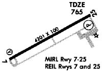
Runways
Runway Summary
| Runways: | 07/25 |
| Longest Runway: | 07/25 is 5600 ft (1707 m) long |
| Runways with an Instrument Approach: | 25 |
ATO Airport Runway Details
| Runway 07/25 | 5600 ft x 100 ft (1707 m x 30 m) | |
| Runway Length Source: | 3RD PARTY SURVEY as of 11/02/2007 | |
| Surface: | Asphalt - Good condition - No special surface treatment | |
| Runway Pavement Class: | 20 /F/B/X/U | |
| Runway Edge Lights: | Medium Intensity | |
Runway Weight Bearing Capacity (in thousands of pounds) |
||
| Single Wheel Landing Gear: | 56.5 | |
| Dual Wheel Landing Gear: | 82.0 | |
Runway 07 |
Runway 25 |
|
Elevation: |
765.4 | 760.5 |
Latitude: |
39-12-29.2829N | 39-12-56.3455N |
Longitude: |
082-14-16.3486W | 082-13-14.2903W |
|
Runway True Alignment: |
061 | 241 |
ILS Type: |
LOC/GS | |
Glide Path Angle: |
3.0 degrees | 3.0 degrees |
Traffic Pattern: |
Left | Left |
Runway Markings Type: |
Nonprecision Instrument | Precision Instrument |
Runway Markings Condition: |
Fair | Fair |
Object at End: |
TREES | TREES |
Object Height: |
10 | 45 |
Distance from End: |
335 | 1115 |
Object Centerline Offset: |
135 ft. right of centerline | 560 ft. left of centerline |
Visual Glide Slope Indicators: |
4-Light PAPI On Left Side Of Runway | 4-Light PAPI On Left Side Of Runway |
REIL: |
Yes | Yes |
Threshold Crossing Height: |
25 | 50 |
Threshold Elevation: |
762.9 | |
Displaced Threshold: |
900 | |
Threshold Latitude: |
39-12-33.6330N | |
Threshold Longitude: |
082-14-06.3756W |
Services
Airframe Repair: |
None |
Powerplant Repair: |
None |
Bottled Oxygen: |
None |
Bulk Oxygen: |
None |
Fuel Available: |
100LL, Jet A+ |
Landing Fees: |
No |
Parking: |
Tiedowns available |
Maps & Diagrams
ATO Sectional
Flight Planning
at skyvector.com
at skyvector.com