Location
Latitude: |
40-56-54.0675N (40.948352) |
Longitude: |
076-38-38.1350W (-76.643926) |
Elevation: |
559.0 feet MSL (170 m MSL) |
Magnetic Variation: |
11.3 W (as of April 2024 from WMM2020 model) |
Time Zone: |
UTC -5.0 (Standard Time) UTC -4.0 (Daylight Savings Time) |
From City: |
03 N.M. SW of Danville, Pennsylvania |
Found On: |
New York Chart |
FAA Region: |
AEA |
Contacts
Manager: |
Publicly owned: |
| CRAIG LAWLER 1413 SUNBURY ROAD DANVILLE, PA 17824 570-274-6190 |
NORTHUMBERLAND & MONTOUR JOINT COMM 1413 SUNBURY ROAD, ST DANVILLE, PA 17821 570-274-6190 |
Operations
Airport Status: |
Operational |
Facility Use: |
Public |
Type: |
Airport |
Activation Date: |
08/1938 |
Control tower: |
No |
Attendance (Months/Days/Hours): |
Months/Days/Hours ALL/ALL/IRREGULAR |
Boundary ARTCC: |
ZNY (New York) |
Responsible ARTCC: |
ZNY (New York) |
Lighting Schedule: |
SEE RMK |
Segmented Circle Indicator: |
Yes |
Traffic Pattern Altitude (MSL): |
1559 feet (475 m) |
NOTAMs Facility: |
IPT |
NOTAM-D Service: |
Yes |
International Airport of Entry: |
No |
Customs Landing Rights: |
No |
Military Landing Rights: |
No |
Civil/Military Joint Use: |
No |
Based Aircraft
| Single Engine: | 38 |
| Ultralights: | 1 |
Annual Operations (as of 04/11/2023)
| Total Operations: | 9200 | |
| GA Local: | 7000 | 76.1% |
| GA Itinerant: | 2000 | 21.7% |
| Military Aircraft: | 200 | 2.2% |
Communications
| CTAF: | 122.800 |
| Unicom: | 122.800 |
| Approach: | WILKES-BARRE 126.3 126.3 |
| Departure: | WILKES-BARRE 126.3 126.3 |
Fixed Based Operators (FBOs) & Fuel
(Click on a business for detail)
Please help us keep this information up to date. This is a FREE SERVICE just like everything else on Airport Guide! If you see that a business needs to be added, modified, or deleted please fill out our Update Form.
To add, modify, or delete a business click here.
Please help us keep this information up to date. This is a FREE SERVICE just like everything else on Airport Guide! If you see that a business needs to be added, modified, or deleted please fill out our Update Form.
Area Code: 570 |
| Business Name | Frequency | Phone | Fuel Grade |
|---|---|---|---|
| Danville Airport
Update FBO info |
Unicom 122.8 | 275-4980 | 80, 100LL |
Flight Service Stations
| Primary | Alternate | |
| FSS on Field: | N | |
| FSS Name (ID): | Williamsport(IPT) | |
| Frequency: | ||
| Toll Free Phone: | 1-800-WX-BRIEF |
Instrument Procedures / Charts
FAA Terminal Procedures valid from 0901Z 03/21/24 to 0901Z 04/18/24.
There are various types of charts available for an airport. They are listed in the Page Type column. Here is a legend for those types:
APD - Airport Diagram
DP - Departure Procedure Charts
HOT - Hot Spots
IAP - Instrument Approach Procedure Charts
MIN - Minimums
STAR - Standard Terminal Arrival Charts
| Page Type | Page Name | Volume | Action Since Last Cycle |
|---|---|---|---|
| IAP | RNAV (GPS) RWY 09 | NE-4 | |
| IAP | RNAV (GPS) RWY 27 | NE-4 | |
| IAP | VOR-A | NE-4 | Deleted |
| MIN | TAKEOFF MINIMUMS | NE-4 |
Terminal Procedures are only available for airports in several countries with more being added all the time. If you are looking for a specific country's charts, please send an email to support(at)airportguide.com stating the country name. This will be used to prioritize the implementation.
Navigation Aids (Navaids) near 8N8
| Dist (NM) | ID | Morse Code | Name | Type | Freq | True Hdg | Mag Hdg |
|---|---|---|---|---|---|---|---|
| 4.6 | MIP | _ _ . . . _ _ . | Milton | VORTAC | 109.20 | 347 | 358 |
| 14.4 | SEG | . . . . _ _ . | Selinsgrove | VOR-DME | 110.40 | 229 | 240 |
| 20.0 | PIX | . _ _ . . . _ . . _ | Picture Rocks | NDB | 344 | 351 | 362 |
| 23.5 | HZL | . . . . _ _ . . . _ . . | Hazleton | VOR | 109.40 | 85 | 96 |
| 23.8 | RAV | . _ . . _ . . . _ | Ravine | VORTAC | 114.60 | 175 | 186 |
| 24.2 | FQM | . . _ . _ _ . _ _ _ | Williamsport | VOR-DME | 114.40 | 345 | 356 |
| 31.0 | BZJ | _ . . . _ _ . . . _ _ _ | Bellgrove | NDB | 328 | 172 | 183 |
| 43.3 | HAR | . . . . . _ . _ . | Harrisburg | VORTAC | 112.50 | 206 | 217 |
| 43.7 | MD | _ _ _ . . | Enola | NDB | 204 | 195 | 206 |
| 45.4 | MDT | _ _ _ . . _ | Harrisburg | VOT | 110.00 | 186 | 197 |
| 47.3 | LVZ | . _ . . . . . _ _ _ . . | Wilkes-Barre | VORTAC | 111.60 | 65 | 77 |
| 48.9 | ETX | . _ _ . . _ | East Texas | VOR-DME | 110.20 | 116 | 128 |
| 49.1 | CX | _ . _ . _ . . _ | Latle | NDB | 219 | 199 | 210 |
| 49.8 | UN | . . _ _ . | Penue | NDB | 388 | 267 | 278 |
| 52.2 | LRP | . _ . . . _ . . _ _ . | Lancaster | VOR-DME | 117.30 | 161 | 172 |
| 55.6 | FJC | . . _ . . _ _ _ _ . _ . | Allentown | VORTAC | 117.50 | 103 | 115 |
| 56.8 | SFK | . . . . . _ . _ . _ | Stonyfork | VOR-DME | 108.60 | 322 | 333 |
| 61.2 | PSB | . _ _ . . . . _ . . . | Philipsburg | VORTAC | 115.50 | 268 | 279 |
| 61.2 | LHY | . _ . . . . . . _ . _ _ | Lake Henry | VORTAC | 110.80 | 58 | 70 |
| 62.6 | EUD | . . . _ _ . . | York | NDB | 254 | 189 | 200 |
Nearby Airports with Fuel
Notices to Airmen (NOTAMS)
Remarks
| A110-1 | DEER & WILDLIFE ON & INVOF ARPT. |
| A110-2 | RC AIRPLANE OPS N OF RWY. |
| A110-3 | FOR CD CTC WILKES-BARRE APCH AT 570-655-2084. |
| A110-4 | LIGHTING NON-STANDARD |
| A110-5 | MAIN RAMP NO PROP WASH INVOF MAIN HNGR DUE TO ACFT PAINTING. |
| A17 | AFT HRS CTC 570-274-6190. |
| A42-27 | THR LGTS DSPLCD 365 FT FM RWY END FOR NGT DISPLACEMENT. RWY END LGTD WITH TWO RED LGTS ON LEFT SIDE (NON STD). |
| A81-APT | ACTVT MIRL RWY 09/27 DRG PERIODS OF DARKNESS ONLY - CTAF. |
| E111 | EXISTED PRIOR TO MAY 15 1959 |
Runways
Runway Summary
| Runways: | 09/27 |
| Longest Runway: | 09/27 is 3000 ft (914 m) long |
| Runways with an Instrument Approach: |
8N8 Airport Runway Details
| Runway 09/27 | 3000 ft x 60 ft (914 m x 18 m) | |
| Surface: | Asphalt - Good condition - No special surface treatment | |
| Runway Edge Lights: | Medium Intensity | |
Runway 09 |
Runway 27 |
|
Elevation: |
540.7 | 554.1 |
Latitude: |
40-56-50.4350N | 40-56-57.7000N |
Longitude: |
076-38-57.0860W | 076-38-19.1840W |
Glide Path Angle: |
0.0 degrees | 0.0 degrees |
Runway Markings Type: |
Nonprecision Instrument | Nonprecision Instrument |
Runway Markings Condition: |
Fair | Fair |
Object at End: |
TREES | TREES |
Object Height: |
49 | 85 |
Distance from End: |
314 | 904 |
Object Centerline Offset: |
246 ft. right of centerline | 296 ft. left of centerline |
Services
Airframe Repair: |
Major |
Powerplant Repair: |
Major |
Bottled Oxygen: |
None |
Bulk Oxygen: |
None |
Fuel Available: |
100LL |
Landing Fees: |
No |
Parking: |
Tiedowns available |
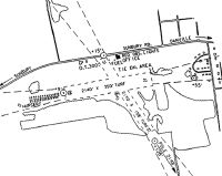
Maps & Diagrams
8N8 Sectional
Flight Planning
at skyvector.com
at skyvector.com