Location
Latitude: |
36-17-28.3000N (36.291194) |
Longitude: |
098-28-32.9000W (-98.475806) |
Elevation: |
1273.8 feet MSL (388 m MSL) |
Magnetic Variation: |
3.8 E (as of April 2024 from WMM2020 model) |
Time Zone: |
UTC -6.0 (Standard Time) UTC -5.0 (Daylight Savings Time) |
From City: |
01 N.M. N of Fairview, Oklahoma |
Found On: |
Wichita Chart |
FAA Region: |
ASW |
Contacts
Manager: |
Publicly owned: |
| MATTHEW REGIER 224 E. OKLAHOMA AVENUE FAIRVIEW, OK 73737 580-227-3788 |
CITY OF FAIRVIEW CITY HALL 203 E. CENTRAL FAIRVIEW, OK 73737 580-227-4416 |
Operations
Airport Status: |
Operational |
Facility Use: |
Public |
Type: |
Airport |
Activation Date: |
03/1948 |
Control tower: |
No |
Attendance (Months/Days/Hours): |
Months/Days/Hours ALL/MON-SAT/DALGT |
Boundary ARTCC: |
ZKC (Kansas City) |
Responsible ARTCC: |
ZKC (Kansas City) |
Lighting Schedule: |
SS-SR |
Segmented Circle Indicator: |
Yes |
Traffic Pattern Altitude (MSL): |
2274 feet (693 m) |
NOTAMs Facility: |
MLC |
NOTAM-D Service: |
Yes |
International Airport of Entry: |
No |
Customs Landing Rights: |
No |
Military Landing Rights: |
Yes |
Civil/Military Joint Use: |
No |
Based Aircraft
| Single Engine: | 11 |
Annual Operations (as of 08/24/2018)
| Total Operations: | 5400 | |
| GA Local: | 3000 | 55.6% |
| GA Itinerant: | 2400 | 44.4% |
Communications
| CTAF: | 122.800 |
| Unicom: | 122.800 |
| Approach: | VANCE 126.75 126.75 KANSAS CITY ARTCC |
| Departure: | VANCE 126.75 126.75 KANSAS CITY ARTCC |
- APCH/DEP CTL SVC PRVDD BY KANSAS CITY ARTCC (ZKC) ON FREQS 127.8/319.1 (PONCA CITY RCAG) WHEN VANCE APCH CTL (END) CLSD.
Fixed Based Operators (FBOs) & Fuel
(Click on a business for detail)
Please help us keep this information up to date. This is a FREE SERVICE just like everything else on Airport Guide! If you see that a business needs to be added, modified, or deleted please fill out our Update Form.
To add, modify, or delete a business click here.
Please help us keep this information up to date. This is a FREE SERVICE just like everything else on Airport Guide! If you see that a business needs to be added, modified, or deleted please fill out our Update Form.
Area Code: 580 |
| Business Name | Frequency | Phone | Fuel Grade |
|---|---|---|---|
| Regier Flying Service
Update FBO info |
Unicom 122.8 | 227-2760 | 100LL |
Flight Service Stations
| Primary | Alternate | |
| FSS on Field: | N | |
| FSS Name (ID): | Mc Alester(MLC) | |
| Frequency: | ||
| Toll Free Phone: | 1-800-WX-BRIEF |
Instrument Procedures / Charts
FAA Terminal Procedures valid from 0901Z 03/21/24 to 0901Z 04/18/24.
There are various types of charts available for an airport. They are listed in the Page Type column. Here is a legend for those types:
APD - Airport Diagram
DP - Departure Procedure Charts
HOT - Hot Spots
IAP - Instrument Approach Procedure Charts
MIN - Minimums
STAR - Standard Terminal Arrival Charts
| Page Type | Page Name | Volume | Action Since Last Cycle |
|---|---|---|---|
| IAP | RNAV (GPS) RWY 17 | SC-1 | |
| IAP | RNAV (GPS) RWY 35 | SC-1 | |
| MIN | TAKEOFF MINIMUMS | SC-1 |
Terminal Procedures are only available for airports in several countries with more being added all the time. If you are looking for a specific country's charts, please send an email to support(at)airportguide.com stating the country name. This will be used to prioritize the implementation.
Navigation Aids (Navaids) near 6K4
| Dist (NM) | ID | Morse Code | Name | Type | Freq | True Hdg | Mag Hdg |
|---|---|---|---|---|---|---|---|
| 27.1 | END | . _ . _ . . | Vance | VORTAC | 115.40 | 83 | 79 |
| 33.1 | EI | . . . | Garfy | NDB | 341 | 91 | 87 |
| 33.6 | ODG | _ _ _ _ . . _ _ . | Woodring | VOR-DME | 109.00 | 81 | 77 |
| 36.6 | MDF | _ _ _ . . . . _ . | Mooreland | NDB | 284 | 288 | 284 |
| 37.1 | IFI | . . . . _ . . . | Kingfisher | TACAN | 114.70 | 141 | 137 |
| 54.1 | ANY | . _ _ . _ . _ _ | Anthony | TACAN | 112.90 | 15 | 11 |
| 60.8 | PWA | . _ _ . . _ _ . _ | Wiley Post | VOR-DME | 113.40 | 138 | 135 |
| 61.5 | BZ | _ . . . _ _ . . | Fossi | NDB | 393 | 215 | 211 |
| 64.9 | OK | _ _ _ _ . _ | Tuloo | NDB | 406 | 139 | 136 |
| 65.0 | BFK | _ . . . . . _ . _ . _ | Buffalo | NDB | 215 | 302 | 298 |
| 67.3 | SW | . . . . _ _ | Gabeh | NDB | 255 | 92 | 89 |
| 67.6 | SWO | . . . . _ _ _ _ _ | Stillwater | VOR-DME | 108.40 | 92 | 89 |
| 68.0 | MMB | _ _ _ _ _ . . . | Mitbee | VORTAC | 115.60 | 273 | 269 |
| 69.1 | PER | . _ _ . . . _ . | Pioneer | VORTAC | 113.20 | 66 | 63 |
| 69.7 | OKC | _ _ _ _ . _ _ . _ . | Oklahoma Will Rgs W | VOT | 112.15 | 142 | 139 |
| 70.1 | IRW | . . . _ . . _ _ | Will Rogers | VORTAC | 114.10 | 142 | 139 |
| 72.6 | BFV | _ . . . . . _ . . . . _ | Burns Flat | VORTAC | 110.00 | 209 | 205 |
| 73.6 | PN | . _ _ . _ . | Ponca | NDB | 515 | 63 | 60 |
| 73.7 | RG | . _ . _ _ . | Gally | NDB | 350 | 143 | 140 |
| 74.0 | TIK | _ . . _ . _ | Tinker | TACAN | 115.80 | 133 | 130 |
Nearby Airports with Fuel
Notices to Airmen (NOTAMS)
Remarks
| A110-1 | FOR CD CTC VANCE APCH AT 580-213-6765. WHEN VANCE APCH IS CLSD, CTC KANSAS CITY ARTCC AT 913-254-8508. |
| A70-FUEL-10 | 0LL AVBL DURG WINT MONTHS. |
Runways
Runway Summary
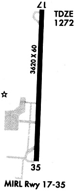
| Runways: | 17/35 |
| Longest Runway: | 17/35 is 4400 ft (1341 m) long |
| Runways with an Instrument Approach: |
6K4 Airport Runway Details
| Runway 17/35 | 4400 ft x 75 ft (1341 m x 23 m) | |
| Runway Length Source: | 3RD PARTY SURVEY as of 11/02/2017 | |
| Surface: | Asphalt/Concrete - Good condition - No special surface treatment | |
| Runway Edge Lights: | Medium Intensity | |
Runway Weight Bearing Capacity (in thousands of pounds) |
||
| Single Wheel Landing Gear: | 30.0 | |
Runway 17 |
Runway 35 |
|
Elevation: |
1264.7 | 1272.5 |
Latitude: |
36-17-50.0764N | 36-17-06.5738N |
Longitude: |
098-28-32.4823W | 098-28-33.4159W |
|
Runway True Alignment: |
180 | 360 |
Glide Path Angle: |
0.0 degrees | 0.0 degrees |
Traffic Pattern: |
Left | Left |
Runway Markings Type: |
Nonprecision Instrument | Nonprecision Instrument |
Runway Markings Condition: |
Good | Good |
Object at End: |
TREES | |
Object Height: |
43 | |
Distance from End: |
1036 | |
Object Centerline Offset: |
0 ft. left of centerline |
Services
Fuel Available: |
100LL |
Landing Fees: |
No |
Parking: |
Tiedowns available |
Maps & Diagrams
6K4 Sectional
Flight Planning
at skyvector.com
at skyvector.com