Location
Latitude: |
30-38-15.4410N (30.637623) |
Longitude: |
086-59-37.1510W (-86.993653) |
Elevation: |
81.7 feet MSL (25 m MSL) |
Magnetic Variation: |
3.5 W (as of April 2024 from WMM2020 model) |
Time Zone: |
UTC -6.0 (Standard Time) UTC -5.0 (Daylight Savings Time) |
From City: |
03 N.M. E of Milton, Florida |
Found On: |
New Orleans Chart |
FAA Region: |
ASO |
Contacts
Manager: |
Publicly owned: |
| JARED LOWE 6491 CAROLINE ST, SUITE 4 MILTON, FL 32570 850-983-1817 |
SANTA ROSA COUNTY 6495 CAROLINE STREET MILTON, FL 32570 850-983-1855 |
Operations
Airport Status: |
Operational |
Facility Use: |
Public |
Type: |
Airport |
Activation Date: |
04/1940 |
Control tower: |
No |
Attendance (Months/Days/Hours): |
Months/Days/Hours ALL/ALL/0700-DUSK |
Boundary ARTCC: |
ZJX (Jacksonville) |
Responsible ARTCC: |
ZJX (Jacksonville) |
Lighting Schedule: |
SEE RMK |
Segmented Circle Indicator: |
Yes |
Traffic Pattern Altitude (MSL): |
1082 feet (330 m) |
NOTAMs Facility: |
GNV |
NOTAM-D Service: |
Yes |
International Airport of Entry: |
No |
Customs Landing Rights: |
No |
Military Landing Rights: |
Yes |
Civil/Military Joint Use: |
No |
Based Aircraft
| Single Engine: | 124 |
| Multi Engine: | 16 |
| GA Helicopters: | 2 |
| Ultralights: | 4 |
Annual Operations (as of 03/07/2018)
| Total Operations: | 93950 | |
| GA Local: | 86400 | 92.0% |
| GA Itinerant: | 7500 | 8.0% |
| Military Aircraft: | 50 | 0.1% |
Communications
| CTAF: | 122.975 |
| Unicom: | 122.975 |
| Approach: | PENSACOLA 124.85 124.85 |
| Departure: | PENSACOLA 124.85 124.85 |
Fixed Based Operators (FBOs) & Fuel
(Click on a business for detail)
Please help us keep this information up to date. This is a FREE SERVICE just like everything else on Airport Guide! If you see that a business needs to be added, modified, or deleted please fill out our Update Form.
To add, modify, or delete a business click here.
Please help us keep this information up to date. This is a FREE SERVICE just like everything else on Airport Guide! If you see that a business needs to be added, modified, or deleted please fill out our Update Form.
Area Code: 850 |
| Business Name | Frequency | Phone | Fuel Grade |
|---|---|---|---|
| Santa Rosa Aviation, Inc.
Update FBO info |
Unicom 122.8 | 623-4151, 623-4704 | 100LL, Jet A |
Flight Service Stations
| Primary | Alternate | |
| FSS on Field: | N | |
| FSS Name (ID): | Gainesville(GNV) | |
| Frequency: | ||
| Toll Free Phone: | 1-800-WX-BRIEF |
Instrument Procedures / Charts
FAA Terminal Procedures valid from 0901Z 03/21/24 to 0901Z 04/18/24.
There are various types of charts available for an airport. They are listed in the Page Type column. Here is a legend for those types:
APD - Airport Diagram
DP - Departure Procedure Charts
HOT - Hot Spots
IAP - Instrument Approach Procedure Charts
MIN - Minimums
STAR - Standard Terminal Arrival Charts
| Page Type | Page Name | Volume | Action Since Last Cycle |
|---|---|---|---|
| IAP | RNAV (GPS) RWY 36 | SE-3 | |
| MIN | TAKEOFF MINIMUMS | SE-3 |
Terminal Procedures are only available for airports in several countries with more being added all the time. If you are looking for a specific country's charts, please send an email to support(at)airportguide.com stating the country name. This will be used to prioritize the implementation.
Navigation Aids (Navaids) near 2R4
| Dist (NM) | ID | Morse Code | Name | Type | Freq | True Hdg | Mag Hdg |
|---|---|---|---|---|---|---|---|
| 3.2 | NGS | _ . _ _ . . . . | Santa Rosa | TACAN | 133.60 | 114 | 118 |
| 5.3 | NSE | _ . . . . . | Whiting | TACAN | 112.30 | 346 | 350 |
| 15.4 | PKZ | . _ _ . _ . _ _ _ . . | Pickens | NDB | 326 | 218 | 221 |
| 19.8 | CEW | _ . _ . . . _ _ | Crestview | VORTAC | 115.90 | 55 | 59 |
| 20.1 | HRT | . . . . . _ . _ | Hurlburt | TACAN | 110.80 | 128 | 132 |
| 20.3 | NUN | _ . . . _ _ . | Saufley | VOR | 112.25 | 240 | 243 |
| 23.7 | NPA | _ . . _ _ . . _ | Pensacola | TACAN | 117.20 | 224 | 227 |
| 26.2 | DWG | _ . . . _ _ _ _ . | Warrington | TACAN | 134.50 | 111 | 115 |
| 26.9 | CE | _ . _ . . | Kobra | NDB | 201 | 61 | 65 |
| 38.7 | ESU | . . . . . . _ | Summerdale | NDB | 204 | 257 | 260 |
| 50.6 | JUY | . _ _ _ . . _ _ . _ _ | Judd | NDB | 264 | 37 | 41 |
| 52.6 | MVC | _ _ . . . _ _ . _ . | Monroeville | VORTAC | 116.80 | 339 | 342 |
| 54.8 | BFM | _ . . . . . _ . _ _ | Brookley | VORTAC | 116.35 | 268 | 271 |
| 65.4 | PFN | . _ _ . . . _ . _ . | Lynne | NDB | 278 | 106 | 110 |
| 66.9 | BVG | _ . . . . . . _ _ _ . | Boll Weevil | NDB | 352 | 50 | 54 |
| 68.0 | MOB | _ _ _ _ _ _ . . . | Wisle | NDB | 248 | 276 | 279 |
| 68.6 | EDN | . _ . . _ . | Enterprise | VOR | 116.60 | 54 | 58 |
| 70.1 | OZ | _ _ _ _ _ . . | Brynt | NDB | 212 | 59 | 63 |
| 70.7 | SJI | . . . . _ _ _ . . | Semmes | VORTAC | 115.30 | 274 | 277 |
| 72.9 | BKK | _ . . . _ . _ _ . _ | Tri County | NDB | 275 | 79 | 83 |
Nearby Airports with Fuel
Notices to Airmen (NOTAMS)
Remarks
| A11 | CTC PERSON: JARED LOWE |
| A110-1 | BE ALERT ARPT SITUATED IN CUT-OFF OF NAS WHITING CASS C AIRSPACE LOCATED 1400 FT OVERHEAD WITHIN 1 MILE FROM THE CENTER OF THE ARPT ON THREE SIDES TO THE EAST, NORTH, AND WEST FROM SURFACE TO 4200 FT. |
| A110-2 | GCO AVBL ON FREQ 121.725 THRU PENSACOLA APCH. |
| A110-3 | INTENSIVE FLIGHT TRAINING INVOF ARPT. |
| A110-4 | LIMITED PARKING ON WEST RAMP FOR TRANSIENT ACFT URGED TO BRING TIE-DOWN ROPES FOR EAST RAMP PARKING. |
| A110-6 | FOR CD IF UNA VIA GCO CTC JACKSONVILLE ARTCC AT 904-845-1592. |
| A14 | AIRPORT PHYSICAL ADDRESS: 5550 NORTH AIRPORT RD. |
| A58-18 | RWY 18 HAS 4 FT BRUSH 50 FT FROM RWY END 98 FT LEFT. |
| A70-FUEL-10 | 0LL FUEL 24 HR CREDIT CARD SVC AVBL. |
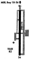
| A81-APT | ACTVT MIRL RWY 18/36 - CTAF. |
| A82 | AUTOMATED UNICOM |
| E111 | VFR OPERATIONS ONLY. |
Runways
Runway Summary
| Runways: | 18/36 |
| Longest Runway: | 18/36 is 3703 ft (1129 m) long |
| Runways with an Instrument Approach: |
2R4 Airport Runway Details
| Runway 18/36 | 3703 ft x 75 ft (1129 m x 23 m) | |
| Runway Length Source: | 3RD PARTY SURVEY as of 04/15/2020 | |
| Surface: | Asphalt - Good condition - No special surface treatment | |
| Runway Pavement Class: | 9 /F/A/X/T | |
| Runway Edge Lights: | Medium Intensity | |
Runway Weight Bearing Capacity (in thousands of pounds) |
||
| Single Wheel Landing Gear: | 22.0 | |
Runway 18 |
Runway 36 |
|
Elevation: |
78.7 | 79.2 |
Latitude: |
30-38-33.7574N | 30-37-57.1239N |
Longitude: |
086-59-36.5564W | 086-59-37.7495W |
|
Runway True Alignment: |
182 | 002 |
Glide Path Angle: |
0.0 degrees | 0.0 degrees |
Traffic Pattern: |
Right | Left |
Runway Markings Type: |
Basic | Nonprecision Instrument |
Runway Markings Condition: |
Fair | Fair |
Object at End: |
BRUSH | TREES |
Object Height: |
4 | 44 |
Distance from End: |
50 | 880 |
Object Centerline Offset: |
98 ft. left of centerline | 225 ft. right of centerline |
REIL: |
Yes | Yes |
Services
Airframe Repair: |
Major |
Powerplant Repair: |
Major |
Bottled Oxygen: |
None |
Bulk Oxygen: |
None |
Fuel Available: |
100LL |
Landing Fees: |
No |
Parking: |
Tiedowns available |
Maps & Diagrams
2R4 Sectional
Flight Planning
at skyvector.com
at skyvector.com