Location
Latitude: |
37-21-21.3390N (37.355928) |
Longitude: |
087-23-53.5910W (-87.39822) |
Elevation: |
439.1 feet MSL (134 m MSL) |
Magnetic Variation: |
3.8 W (as of April 2024 from WMM2020 model) |
Time Zone: |
UTC -6.0 (Standard Time) UTC -5.0 (Daylight Savings Time) |
From City: |
05 N.M. NE of Madisonville, Kentucky |
Found On: |
St Louis Chart |
FAA Region: |
ASO |
Contacts
Manager: |
Publicly owned: |
| EMILY HERRON 162 AIRPORT ROAD MADISONVILLE, KY 42431 270-821-3453 |
CITY OF MADISONVILLE CITY HALL MADISONVILLE, KY 42431 270-824-2110 |
Operations
Airport Status: |
Operational |
Facility Use: |
Public |
Type: |
Airport |
Activation Date: |
04/1944 |
Control tower: |
No |
Attendance (Months/Days/Hours): |
Months/Days/Hours ALL/MON-FRI/0700-1700 |
Boundary ARTCC: |
ZID (Indianapolis) |
Responsible ARTCC: |
ZID (Indianapolis) |
Lighting Schedule: |
SEE RMK |
Segmented Circle Indicator: |
Yes |
Traffic Pattern Altitude (MSL): |
1439 feet (439 m) |
NOTAMs Facility: |
LOU |
NOTAM-D Service: |
Yes |
International Airport of Entry: |
No |
Customs Landing Rights: |
No |
Military Landing Rights: |
Yes |
Civil/Military Joint Use: |
No |
Based Aircraft
| Single Engine: | 24 |
| Multi Engine: | 1 |
| Jet Engine: | 1 |
| GA Helicopters: | 3 |
Annual Operations (as of 11/08/2016)
| Total Operations: | 15790 | |
| GA Local: | 9174 | 58.1% |
| GA Itinerant: | 6116 | 38.7% |
| Military Aircraft: | 500 | 3.2% |
Communications
| CTAF: | 122.700 |
| Unicom: | 122.700 |
| Clearance Del.: | 120.1 120.1 120.1 |
| Approach: | EVANSVILLE INDIANAPOLIS ARTCC |
| Departure: | EVANSVILLE INDIANAPOLIS ARTCC |
| AWOS-3: | 126.475 (270-821-4554) |
- APCH/DEP SVC PRVDD BY INDIANAPOLIS ARTCC ON FREQS 128.3/291.625 (EVANSVILLE RCAG) WHEN EVANSVILLE APCH CTL CLSD.
Fixed Based Operators (FBOs) & Fuel
(Click on a business for detail)
Please help us keep this information up to date. This is a FREE SERVICE just like everything else on Airport Guide! If you see that a business needs to be added, modified, or deleted please fill out our Update Form.
To add, modify, or delete a business click here.
Please help us keep this information up to date. This is a FREE SERVICE just like everything else on Airport Guide! If you see that a business needs to be added, modified, or deleted please fill out our Update Form.
Area Code: 270 |
| Business Name | Frequency | Phone | Fuel Grade |
|---|---|---|---|
| Madisonville Flying Service
Update FBO info |
Unicom 122.7 | 821-3453 | 100LL, Jet A |
Flight Service Stations
| Primary | Alternate | |
| FSS on Field: | N | |
| FSS Name (ID): | Louisville(LOU) | |
| Frequency: | ||
| Toll Free Phone: | 1-800-WX-BRIEF |
Instrument Procedures / Charts
FAA Terminal Procedures valid from 0901Z 03/21/24 to 0901Z 04/18/24.
There are various types of charts available for an airport. They are listed in the Page Type column. Here is a legend for those types:
APD - Airport Diagram
DP - Departure Procedure Charts
HOT - Hot Spots
IAP - Instrument Approach Procedure Charts
MIN - Minimums
STAR - Standard Terminal Arrival Charts
| Page Type | Page Name | Volume | Action Since Last Cycle |
|---|---|---|---|
| IAP | RNAV (GPS) RWY 05 | SE-1 | |
| IAP | RNAV (GPS) RWY 23 | SE-1 | |
| MIN | ALTERNATE MINIMUMS | SE-1 | |
| MIN | TAKEOFF MINIMUMS | SE-1 |
Terminal Procedures are only available for airports in several countries with more being added all the time. If you are looking for a specific country's charts, please send an email to support(at)airportguide.com stating the country name. This will be used to prioritize the implementation.
Navigation Aids (Navaids) near 2I0
| Dist (NM) | ID | Morse Code | Name | Type | Freq | True Hdg | Mag Hdg |
|---|---|---|---|---|---|---|---|
| 6.6 | CCT | _ . _ . _ . _ . _ | Central City | DME | 109.8 | 76 | 80 |
| 13.8 | GMH | _ _ . _ _ . . . . | Muhlenberg | NDB | 362 | 124 | 128 |
| 20.2 | OW | _ _ _ . _ _ | Higuy | NDB | 341 | 33 | 37 |
| 25.8 | OWB | _ _ _ . _ _ _ . . . | Owensboro | VOR-DME | 108.60 | 25 | 29 |
| 28.7 | HIX | . . . . . . _ . . _ | Honey Grove | NDB | 356 | 174 | 178 |
| 37.1 | FK | . . _ . _ . _ | Airbe | NDB | 273 | 181 | 185 |
| 38.5 | PXV | . _ _ . _ . . _ . . . _ | Pocket City | VORTAC | 113.30 | 333 | 337 |
| 41.5 | PDW | . _ _ . _ . . . _ _ | Evansville | NDB | 284 | 351 | 355 |
| 42.1 | HXW | . . . . _ . . _ . _ _ | Screaming Eagle | TACAN | 114.90 | 187 | 191 |
| 44.0 | CKV | _ . _ . _ . _ . . . _ | Clarksville | VOR-DME | 110.60 | 180 | 184 |
| 49.7 | CK | _ . _ . _ . _ | Snuff | NDB | 335 | 179 | 183 |
| 51.9 | TEL | _ . . _ . . | Tell City | NDB | 206 | 40 | 44 |
| 52.3 | BW | _ . . . . _ _ | Noora | NDB | 236 | 122 | 126 |
| 52.4 | BWG | _ . . . . _ _ _ _ . | Bowling Green | DME | 117.9 | 119 | 123 |
| 57.2 | EU | . . . _ | Murey | NDB | 368 | 228 | 231 |
| 57.3 | ON | _ _ _ _ . | Music | NDB | 279 | 159 | 163 |
| 57.6 | HNB | . . . . _ . _ . . . | Huntingburg | VOR-DME | 109.20 | 21 | 25 |
| 61.0 | HSB | . . . . . . . _ . . . | Harrisburg-Raleigh | NDB | 230 | 296 | 299 |
| 62.1 | BDD | _ . . . _ . . _ . . | Bellgrade | NDB | 254 | 258 | 261 |
| 63.6 | MYS | _ _ _ . _ _ . . . | Mystic | VOR | 108.20 | 59 | 63 |
Nearby Airports with Fuel
Notices to Airmen (NOTAMS)
Remarks
| A110-2 | FOR CD WHEN RCO 120.1 OTS CTC EVANSVILLE APCH AT 812-436-4689, WHEN APCH CLSD CTC INDIANAPOLIS ARTCC AT 317-247-2411. |
| A16 | AFT HR - 270-871-5743. |
| A81-APT | ACTVT REIL RWY 05 & 23 - CTAF. HIRL RWY 05/23 PRESET LOW INTST; INCR INTST - CTAF. |
Runways
Runway Summary
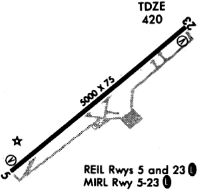
| Runways: | 05/23 |
| Longest Runway: | 05/23 is 6051 ft (1844 m) long |
| Runways with an Instrument Approach: |
2I0 Airport Runway Details
| Runway 05/23 | 6051 ft x 100 ft (1844 m x 30 m) | |
| Runway Length Source: | 3RD PARTY SURVEY as of 09/17/2017 | |
| Surface: | Asphalt - Fair condition - No special surface treatment | |
| Runway Pavement Class: | 36 /F/C/X/T | |
| Runway Edge Lights: | High Intensity | |
Runway Weight Bearing Capacity (in thousands of pounds) |
||
| Single Wheel Landing Gear: | 92.0 | |
| Dual Wheel Landing Gear: | 127.0 | |
Runway 05 |
Runway 23 |
|
Elevation: |
439.1 | 418.2 |
Latitude: |
37-21-02.7139N | 37-21-39.9620N |
Longitude: |
087-24-22.9066W | 087-23-24.2713W |
|
Runway True Alignment: |
051 | 231 |
Glide Path Angle: |
3.0 degrees | 3.0 degrees |
Traffic Pattern: |
Left | Left |
Runway Markings Type: |
Nonprecision Instrument | Nonprecision Instrument |
Runway Markings Condition: |
Fair | Fair |
Object at End: |
TREES | |
Object Height: |
79 | |
Distance from End: |
946 | |
Object Centerline Offset: |
434 ft. left of centerline | |
Visual Glide Slope Indicators: |
4-Light PAPI On Left Side Of Runway | 4-Light PAPI On Left Side Of Runway |
Approach Light System: |
Omnidirectional Approach Lighting System | |
REIL: |
Yes | Yes |
Threshold Crossing Height: |
36 | 41 |
Services
Airframe Repair: |
Major |
Powerplant Repair: |
Major |
Bottled Oxygen: |
None |
Fuel Available: |
100LL, Jet A+ |
Landing Fees: |
No |
Parking: |
Hangars and tiedowns available |
Maps & Diagrams
2I0 Sectional
Flight Planning
at skyvector.com
at skyvector.com