Location
Latitude: |
36-20-58.9330N (36.349704) |
Longitude: |
084-56-47.9520W (-84.946653) |
Elevation: |
1694.3 feet MSL (516 m MSL) |
Magnetic Variation: |
5.4 W (as of April 2024 from WMM2020 model) |
Time Zone: |
UTC -6.0 (Standard Time) UTC -5.0 (Daylight Savings Time) |
From City: |
05 N.M. S of Jamestown, Tennessee |
Found On: |
Cincinnati Chart |
FAA Region: |
ASO |
Contacts
Manager: |
Publicly owned: |
| RONNIE SEAGRAVES 125 AIRPORT RD JAMESTOWN, TN 38556 931-879-8948 |
CITY OF JAMESTOWN CITY HALL PO BOX 670 JAMESTOWN, TN 38556 931-879-8815 |
Operations
Airport Status: |
Operational |
Facility Use: |
Public |
Type: |
Airport |
Control tower: |
No |
Attendance (Months/Days/Hours): |
Months/Days/Hours ALL/MON-SUN/0800-1600 |
Boundary ARTCC: |
ZID (Indianapolis) |
Responsible ARTCC: |
ZID (Indianapolis) |
Lighting Schedule: |
SEE RMK |
Segmented Circle Indicator: |
Yes |
Traffic Pattern Altitude (MSL): |
2694 feet (821 m) |
NOTAMs Facility: |
BNA |
NOTAM-D Service: |
Yes |
International Airport of Entry: |
No |
Customs Landing Rights: |
No |
Military Landing Rights: |
Yes |
Civil/Military Joint Use: |
No |
Based Aircraft
| Single Engine: | 11 |
| Multi Engine: | 1 |
| GA Helicopters: | 1 |
Annual Operations (as of 07/31/2019)
| Total Operations: | 2160 | |
| GA Local: | 840 | 38.9% |
| GA Itinerant: | 1285 | 59.5% |
| Military Aircraft: | 35 | 1.6% |
Communications
| CTAF: | 122.800 |
| Unicom: | 122.800 |
- APCH/DEP SVC PRVDD BY INDIANAPOLIS ARTCC ON FREQS 124.625/371.925 (LONDON 2 RCAG).
Fixed Based Operators (FBOs) & Fuel
(Click on a business for detail)
Please help us keep this information up to date. This is a FREE SERVICE just like everything else on Airport Guide! If you see that a business needs to be added, modified, or deleted please fill out our Update Form.
To add, modify, or delete a business click here.
Please help us keep this information up to date. This is a FREE SERVICE just like everything else on Airport Guide! If you see that a business needs to be added, modified, or deleted please fill out our Update Form.
Area Code: 931 |
| Business Name | Frequency | Phone | Fuel Grade |
|---|
Flight Service Stations
| Primary | Alternate | |
| FSS on Field: | N | |
| FSS Name (ID): | Nashville(BNA) | |
| Frequency: | ||
| Toll Free Phone: | 1-800-WX-BRIEF |
Instrument Procedures / Charts
FAA Terminal Procedures valid from 0901Z 03/21/24 to 0901Z 04/18/24.
There are various types of charts available for an airport. They are listed in the Page Type column. Here is a legend for those types:
APD - Airport Diagram
DP - Departure Procedure Charts
HOT - Hot Spots
IAP - Instrument Approach Procedure Charts
MIN - Minimums
STAR - Standard Terminal Arrival Charts
| Page Type | Page Name | Volume | Action Since Last Cycle |
|---|---|---|---|
| IAP | RNAV (GPS)-B | SE-1 | |
| IAP | RNAV (GPS)-C | SE-1 | |
| MIN | TAKEOFF MINIMUMS | SE-1 |
Terminal Procedures are only available for airports in several countries with more being added all the time. If you are looking for a specific country's charts, please send an email to support(at)airportguide.com stating the country name. This will be used to prioritize the implementation.
Navigation Aids (Navaids) near 2A1
| Dist (NM) | ID | Morse Code | Name | Type | Freq | True Hdg | Mag Hdg |
|---|---|---|---|---|---|---|---|
| 17.6 | LVT | . _ . . . . . _ _ | Livingston | VOR-DME | 114.35 | 323 | 328 |
| 25.4 | BPO | _ . . . . _ _ . _ _ _ | Piney Grove | NDB | 403 | 63 | 69 |
| 34.2 | HCH | . . . . _ . _ . . . . . | Hinch Mountain | VOR-DME | 117.60 | 182 | 187 |
| 37.8 | HEM | . . . . . _ _ | Huchn | NDB | 233 | 235 | 240 |
| 40.8 | CDX | _ . _ . _ . . _ . . _ | Cumberland River | NDB | 388 | 18 | 24 |
| 47.1 | SKN | . . . _ . _ _ . | Hurricane | NDB | 256 | 242 | 247 |
| 52.1 | DTE | _ . . _ . | Mark Anton | NDB | 394 | 179 | 184 |
| 53.4 | RN | . _ . _ . | Warri | NDB | 209 | 228 | 233 |
| 55.5 | MNV | _ _ _ . . . . _ | Madisonville | NDB | 361 | 150 | 156 |
| 56.1 | TYS | _ _ . _ _ . . . | Knoxville | VOT | 112.00 | 124 | 130 |
| 57.5 | LOZ | . _ . . _ _ _ _ _ . . | London | VOR-DME | 116.55 | 44 | 50 |
| 57.5 | VXV | . . . _ _ . . _ . . . _ | Volunteer | VORTAC | 116.40 | 117 | 123 |
| 60.3 | MMI | _ _ _ _ . . | Mc Minn County | NDB | 242 | 161 | 167 |
| 64.7 | TYC | _ _ . _ _ _ . _ . | Taylor County | NDB | 272 | 347 | 352 |
| 65.0 | BVQ | _ . . . . . . _ _ _ . _ | Beaver Creek | NDB | 260 | 308 | 313 |
| 66.8 | JUE | . _ _ _ . . _ . | Lebanon | NDB | 414 | 262 | 267 |
| 71.7 | CQN | _ . _ . _ _ . _ _ . | Daisy | NDB | 341 | 188 | 193 |
| 71.8 | HDI | . . . . _ . . . . | Hardwick | NDB | 369 | 178 | 183 |
| 72.6 | JXT | . _ _ _ _ . . _ _ | Jefferson | NDB | 346 | 100 | 106 |
| 72.8 | FQW | . . _ . _ _ . _ . _ _ | Walter Hill | NDB | 371 | 251 | 256 |
Nearby Airports with Fuel
Notices to Airmen (NOTAMS)
Remarks
| A110-1 | FOR CD CTC INDIANAPOLIS ARTCC AT 317-247-2411. |
| A16 | AFT HR - 931-879-5685. |
| A81-APT | ACTVT REIL RWY 01 & 19; MIRL 01/19 - CTAF. MIRL 01/19 INCR INTST - CTAF. PAPI RWY 01 & 19 ON CONSLY. |
| E111 | VFR OPS ONLY. |
Runways
Runway Summary
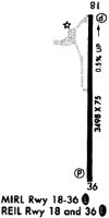
| Runways: | 01/19 |
| Longest Runway: | 01/19 is 3498 ft (1066 m) long |
| Runways with an Instrument Approach: |
2A1 Airport Runway Details
| Runway 01/19 | 3498 ft x 75 ft (1066 m x 23 m) | |
| Runway Length Source: | 3RD PARTY SURVEY as of 04/23/2021 | |
| Surface: | Asphalt - Excellent condition - No special surface treatment | |
| Runway Edge Lights: | Medium Intensity | |
Runway Weight Bearing Capacity (in thousands of pounds) |
||
| Single Wheel Landing Gear: | 17.0 | |
| Dual Wheel Landing Gear: | 22.0 | |
Runway 01 |
Runway 19 |
|
Elevation: |
1678.6 | 1694.3 |
Latitude: |
36-20-41.6394N | 36-21-16.2270N |
Longitude: |
084-56-48.0929W | 084-56-47.8114W |
|
Runway True Alignment: |
000 | 180 |
Glide Path Angle: |
4.0 degrees | 4.0 degrees |
Traffic Pattern: |
Left | Left |
Runway Markings Type: |
Nonprecision Instrument | Nonprecision Instrument |
Runway Markings Condition: |
Fair | Fair |
Object at End: |
TREE | TREE |
Object Height: |
46 | 90 |
Distance from End: |
941 | 1803 |
Object Centerline Offset: |
2 ft. left of centerline | 438 ft. right of centerline |
Visual Glide Slope Indicators: |
4-Light PAPI On Left Side Of Runway | 4-Light PAPI On Left Side Of Runway |
REIL: |
Yes | Yes |
Threshold Crossing Height: |
30 | 32 |
Services
Airframe Repair: |
Minor |
Powerplant Repair: |
Major |
Bottled Oxygen: |
None |
Bulk Oxygen: |
None |
Fuel Available: |
100LL, Jet A |
Landing Fees: |
No |
Parking: |
Hangars and tiedowns available |
Maps & Diagrams
2A1 Sectional
Flight Planning
at skyvector.com
at skyvector.com