Location
Latitude: |
43-13-31.9870N (43.225552) |
Longitude: |
074-06-52.0207W (-74.11445) |
Elevation: |
1070.0 feet MSL (326 m MSL) |
Magnetic Variation: |
13 W (as of April 2024 from WMM2020 model) |
Time Zone: |
UTC -5.0 (Standard Time) UTC -4.0 (Daylight Savings Time) |
From City: |
01 N.M. NW of Edinburg, New York |
Found On: |
New York Chart |
FAA Region: |
AEA |
Contacts
Manager: |
Privately owned: |
| MR BILL DEE WADE 23 WHEELER RD EDINBURG, NY 12134 518-863-2725 |
ELAYNE WADE 23 WHEELER RD EDINBURG, NY 12134 518-775-7431 |
Operations
Airport Status: |
Operational |
Facility Use: |
Public |
Type: |
Airport |
Control tower: |
No |
Attendance (Months/Days/Hours): |
Months/Days/Hours Unattended |
Boundary ARTCC: |
ZBW (Boston) |
Responsible ARTCC: |
ZBW (Boston) |
Segmented Circle Indicator: |
Yes |
Traffic Pattern Altitude (MSL): |
2070 feet (631 m) |
NOTAMs Facility: |
BTV |
NOTAM-D Service: |
Yes |
Based Aircraft
| Single Engine: | 8 |
| Ultralights: | 1 |
Annual Operations (as of 08/30/2019)
| Total Operations: | 3200 | |
| GA Local: | 2500 | 78.1% |
| GA Itinerant: | 600 | 18.8% |
| Military Aircraft: | 100 | 3.1% |
Communications
| CTAF: | 122.800 |
| Unicom: | 122.800 |
Fixed Based Operators (FBOs) & Fuel
(Click on a business for detail)
Please help us keep this information up to date. This is a FREE SERVICE just like everything else on Airport Guide! If you see that a business needs to be added, modified, or deleted please fill out our Update Form.
To add, modify, or delete a business click here.
Please help us keep this information up to date. This is a FREE SERVICE just like everything else on Airport Guide! If you see that a business needs to be added, modified, or deleted please fill out our Update Form.
Area Code: 518 |
| Business Name | Frequency | Phone | Fuel Grade |
|---|
Flight Service Stations
| Primary | Alternate | |
| FSS on Field: | N | |
| FSS Name (ID): | Burlington(BTV) | |
| Frequency: | ||
| Toll Free Phone: | 1-800-WX-BRIEF |
Instrument Procedures / Charts
Terminal Procedures are only available for airports in several countries with more being added all the time. If you are looking for a specific country's charts, please send an email to support(at)airportguide.com stating the country name. This will be used to prioritize the implementation.
Navigation Aids (Navaids) near 1F2
| Dist (NM) | ID | Morse Code | Name | Type | Freq | True Hdg | Mag Hdg |
|---|---|---|---|---|---|---|---|
| 16.6 | JJH | . _ _ _ . _ _ _ . . . . | Johnstown | NDB | 523 | 215 | 228 |
| 22.3 | GF | _ _ . . . _ . | Ganse | NDB | 209 | 85 | 98 |
| 23.0 | GFL | _ _ . . . _ . . _ . . | Glens Falls | VORTAC | 110.20 | 72 | 85 |
| 23.7 | HEU | . . . . . . . _ | Hunter | NDB | 356 | 160 | 173 |
| 31.7 | ALB | . _ . _ . . _ . . . | Albany | VOT | 108.20 | 156 | 169 |
| 31.8 | ALB | . _ . _ . . _ . . . | Albany | VORTAC | 115.30 | 154 | 167 |
| 36.5 | CAM | _ . _ . . _ _ _ | Cambridge | VOR-DME | 115.00 | 112 | 125 |
| 47.5 | UCA | . . _ _ . _ . . _ | Utica | TACAN | 111.20 | 255 | 268 |
| 53.9 | RUT | . _ . . . _ _ | Rutland | DME | 111 | 69 | 82 |
| 54.3 | OZ | _ _ _ _ _ . . | Kring | NDB | 279 | 225 | 238 |
| 56.3 | R | . _ . | Chitt | FAN MARKER | 63 | 76 | |
| 57.6 | VWD | . . . _ . _ _ _ . . | Mount Snow | NDB | 224 | 107 | 120 |
| 58.1 | DYO | _ . . _ . _ _ _ _ _ | Smuto | NDB | 221 | 59 | 72 |
| 60.8 | PFH | . _ _ . . . _ . . . . . | Philmont | NDB | 272 | 163 | 176 |
| 66.8 | SXD | . . . _ . . _ _ . . | Springfield | NDB | 265 | 87 | 100 |
| 67.3 | RKA | . _ . _ . _ . _ | Rockdale | VOR-DME | 112.60 | 227 | 240 |
| 69.7 | SLK | . . . . _ . . _ . _ | Saranac Lake | DME | 109.2 | 356 | 369 |
| 70.0 | GBR | _ _ . _ . . . . _ . | Great Barrington | NDB | 395 | 153 | 166 |
| 73.0 | DNY | _ . . _ . _ . _ _ | Delancey | VOR-DME | 112.10 | 210 | 223 |
| 74.6 | IVV | . . . . . _ . . . _ | White River | NDB | 379 | 73 | 86 |
Nearby Airports with Fuel
Notices to Airmen (NOTAMS)
Remarks
| A110-1 | ULTRALGT ACFT ON & INVOF ARPT. |
| A110-3 | ACFT PARKED/HANGARED ON NON ARPT LAND. CROSS PUBLIC ROAD TO/FM ARPT. |
| A110-4 | RWY 24; +35 - 50 FT TREES, 90 - 250 FT FROM THLD, 0 - 125 FT R OF CNTRLN AND +50 FT TREES, 350 - 425 FT FROM THLD 110 - 150 FT L OF CNTRLN. |
| A110-5 | RWY 19; +17 - 52 FT TREES, 0 - 230 FT FROM THLD, 50 - 100 FT R OF CNTRLN. |
| A110-6 | RWY 1; +30 - 60 FT TREES, 0 - 240 FROM THLD, 15 - 100 FT L AND R OF CNTRLN. |
| A110-7 | RWY 6; +20 - 65 FT TREES, 0 - 500 FT FROM THLD, 30 - 150 L AND R OF CNTRLN. |
| A110-8 | FOR CD CTC ALBANY APCH AT 518-862-2299. |
| A110-9 | ARPT NOT PLOWED OR MNTND DURG WINTER MONTHS; RWY SFC CAN BE SOFT AS FROST LEAVES THE GND IN SPRING. |
| A32-01/19 | RWY WIDTH EDGE MARKED WITH RED CONES ALL SEASONS EXCEPT WINTER |
| A32-06/24 | RWY WIDTH EDGE MARKED WITH RED CONES ALL SEASONS EXCEPT WINTER |
| A52-01 | ROAD ON BOTH SIDES OF CTRLN RY 01. |
| A52-06 | ROAD ON BOTH SIDES OF CTRLN AT AN ANGLE TO RY 06. |
| A52-19 | ROAD ON BOTH SIDES OF CTRLN AT AN ANGLE TO RY 19. |
| A52-24 | ROAD ON BOTH SIDES OF CTRLN RY 24. |
| E111 | ESTABD PRIOR TO 1959 |
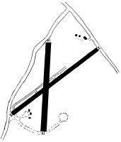
Runways
Runway Summary
| Runways: | 01/19 06/24 |
| Longest Runway: | 06/24 is 2400 ft (732 m) long |
| Runways with an Instrument Approach: |
1F2 Airport Runway Details
| Runway 01/19 | 2000 ft x 100 ft (610 m x 30 m) | |
| Surface: | Turf - Good condition - No special surface treatment | |
Runway 01 |
Runway 19 |
|
Elevation: |
1048.0 | 1067.0 |
Latitude: |
43-13-22.2128N | 43-13-41.9699N |
Longitude: |
074-06-53.7688W | 074-06-53.4423W |
|
Runway True Alignment: |
001 | 181 |
Glide Path Angle: |
0.0 degrees | 0.0 degrees |
Traffic Pattern: |
Left | Left |
Object at End: |
TREES | TREES |
Object Height: |
53 | 41 |
Distance from End: |
0 | 0 |
Object Centerline Offset: |
50 ft. left and right of centerline | 113 ft. right of centerline |
| Runway 06/24 | 2400 ft x 100 ft (732 m x 30 m) | |
| Surface: | Turf - Good condition - No special surface treatment | |
Runway 06 |
Runway 24 |
|
Elevation: |
1047.0 | 1060.0 |
Latitude: |
43-13-23.8000N | 43-13-40.0000N |
Longitude: |
074-07-02.5000W | 074-06-38.9000W |
|
Runway True Alignment: |
047 | 227 |
Glide Path Angle: |
0.0 degrees | 0.0 degrees |
Traffic Pattern: |
Left | Left |
Object at End: |
ROAD | ROAD |
Object Height: |
15 | 15 |
Distance from End: |
0 | 0 |
Object Centerline Offset: |
50 ft. left and right of centerline | 113 ft. right of centerline |
Services
Airframe Repair: |
Major |
Powerplant Repair: |
Major |
Bottled Oxygen: |
None |
Bulk Oxygen: |
None |
Fuel Available: |
100LL |
Landing Fees: |
No |
Parking: |
Tiedowns available |
Maps & Diagrams
1F2 Sectional
Flight Planning
at skyvector.com
at skyvector.com