Location
Latitude: |
41-41-45.3000N (41.695917) |
Longitude: |
088-07-46.2000W (-88.1295) |
Elevation: |
674.9 feet MSL (206 m MSL) |
Magnetic Variation: |
3.7 W (as of April 2024 from WMM2020 model) |
Time Zone: |
UTC -6.0 (Standard Time) UTC -5.0 (Daylight Savings Time) |
From City: |
00 N.M. NW of Bolingbrook, Illinois |
Found On: |
Chicago Chart |
FAA Region: |
AGL |
Contacts
Manager: |
Publicly owned: |
| JOSEPH DE PAULO 130 S CLOW INTL PARKWAY BOLINGBROOK, IL 60490 630-378-0479 |
VILLAGE OF BOLINGBROOK 375 W BRIARCLIFF ROAD BOLINGBROOK, IL 60440 630-226-8400 |
Operations
Airport Status: |
Operational |
Facility Use: |
Public |
Type: |
Airport |
Activation Date: |
03/1967 |
Control tower: |
No |
Attendance (Months/Days/Hours): |
Months/Days/Hours ALL/ALL/0700-1800 |
Boundary ARTCC: |
ZAU (Chicago) |
Responsible ARTCC: |
ZAU (Chicago) |
Lighting Schedule: |
SEE RMK |
Segmented Circle Indicator: |
No |
Traffic Pattern Altitude (MSL): |
1675 feet (511 m) |
NOTAMs Facility: |
IKK |
NOTAM-D Service: |
Yes |
Based Aircraft
| Single Engine: | 58 |
| Multi Engine: | 8 |
| GA Helicopters: | 1 |
Annual Operations (as of 08/31/2023)
| Total Operations: | 50000 | |
| Air Taxi: | 2000 | 4.0% |
| GA Local: | 26000 | 52.0% |
| GA Itinerant: | 22000 | 44.0% |
Communications
| CTAF: | 122.900 |
| Approach: | CHICAGO 119.35 119.35 |
| Departure: | CHICAGO 119.35 119.35 |
Fixed Based Operators (FBOs) & Fuel
(Click on a business for detail)
Please help us keep this information up to date. This is a FREE SERVICE just like everything else on Airport Guide! If you see that a business needs to be added, modified, or deleted please fill out our Update Form.
To add, modify, or delete a business click here.
Please help us keep this information up to date. This is a FREE SERVICE just like everything else on Airport Guide! If you see that a business needs to be added, modified, or deleted please fill out our Update Form.
Area Code: 630 |
| Business Name | Frequency | Phone | Fuel Grade |
|---|---|---|---|
| A & M Aviation, Inc.
Website Update FBO info |
Unicom 122.9, Arinc 123.5 | 759-1555 | 100LL |
| B & B Aircraft Corporation
Update FBO info |
Unicom 123.5 | 759-9223, 554-6075 | 100LL |
Flight Service Stations
| Primary | Alternate | |
| FSS on Field: | N | |
| FSS Name (ID): | Kankakee(IKK) | |
| Frequency: | ||
| Toll Free Phone: | 1-800-WX-BRIEF |
Instrument Procedures / Charts
FAA Terminal Procedures valid from 0901Z 03/21/24 to 0901Z 04/18/24.
There are various types of charts available for an airport. They are listed in the Page Type column. Here is a legend for those types:
APD - Airport Diagram
DP - Departure Procedure Charts
HOT - Hot Spots
IAP - Instrument Approach Procedure Charts
MIN - Minimums
STAR - Standard Terminal Arrival Charts
| Page Type | Page Name | Volume | Action Since Last Cycle |
|---|---|---|---|
| IAP | RNAV (GPS)-B | EC-3 | |
| IAP | VOR-A | EC-3 | |
| MIN | TAKEOFF MINIMUMS | EC-3 |
Terminal Procedures are only available for airports in several countries with more being added all the time. If you are looking for a specific country's charts, please send an email to support(at)airportguide.com stating the country name. This will be used to prioritize the implementation.
Navigation Aids (Navaids) near 1C5
| Dist (NM) | ID | Morse Code | Name | Type | Freq | True Hdg | Mag Hdg |
|---|---|---|---|---|---|---|---|
| 12.3 | JOT | . _ _ _ _ _ _ _ | Joliet | VOR-DME | 112.30 | 223 | 227 |
| 13.2 | HK | . . . . _ . _ | Ermin | NDB | 332 | 83 | 87 |
| 15.3 | DPA | _ . . . _ _ . . _ | Dupage | VOR-DME | 108.40 | 319 | 323 |
| 16.9 | ME | _ _ . | Deana | NDB | 350 | 15 | 19 |
| 17.7 | MDW | _ _ _ . . . _ _ | Chicago Midway | VOT | 111.00 | 72 | 76 |
| 19.9 | MX | _ _ _ . . _ | Kedzi | NDB | 248 | 81 | 85 |
| 20.2 | ORD | _ _ _ . _ . _ . . | Chicago O'hare | VOR-DME | 113.90 | 29 | 33 |
| 20.6 | GCO | _ _ . _ . _ . _ _ _ | Chicago | DME | 108.25 | 29 | 33 |
| 27.4 | CGT | _ . _ . _ _ . _ | Chicago Heights | VORTAC | 114.20 | 113 | 117 |
| 29.8 | EON | . _ _ _ _ . | Peotone | VORTAC | 113.20 | 149 | 153 |
| 32.5 | OBK | _ _ _ _ . . . _ . _ | Northbrook | VOR-DME | 113.00 | 14 | 18 |
| 38.2 | OIX | _ _ _ . . _ . . _ | Ottawa | NDB | 266 | 238 | 241 |
| 39.4 | IKK | . . _ . _ _ . _ | Kankakee | DME | 111.6 | 161 | 165 |
| 41.9 | IK | . . _ . _ | Lukow | NDB | 272 | 165 | 169 |
| 48.3 | UG | . . _ _ _ . | Wauke | NDB | 379 | 17 | 21 |
| 50.0 | RF | . _ . . . _ . | Gilmy | NDB | 275 | 300 | 303 |
| 52.1 | EN | . _ . | Codee | NDB | 389 | 4 | 8 |
| 54.9 | ENW | . _ . . _ _ | Kenosha | DME | 109.2 | 9 | 13 |
| 57.3 | RFD | . _ . . . _ . _ . . | Rockford | DME | 110.8 | 304 | 307 |
| 58.1 | VP | . . . _ . _ _ . | Sedly | NDB | 212 | 104 | 108 |
Nearby Airports with Fuel
Notices to Airmen (NOTAMS)
Remarks
| A110-2 | TWY 20 FT WIDE; LARGE ACFT CONSIDER BACK-TAXI. |
| A110-3 | NO TGL; FULL STOP LDG ONLY. |
| A110-4 | FOR CD CTC CHICAGO APCH AT 847-289-0926. |
| A110-5 | FLT SCHOOL OPS ONLY - 123.50. |
| A110-6 | WILDLIFE ON AND INVOF ARPT. |
| A110-7 | RESTAURANT ON ARPT. |
| A15 | EMAIL ADDRESS: JOEDEPAULO@GMAIL.COM |
| A30A-18 | USE RWY 18 IN CALM WND OR DRCT CROSSWINDS. |
| A81-APT | MIRL RY 18/36 PRESET LOW INTST DUSK-DAWN TO INCR INTST - CTAF |
| E111 | TFC PATTERNS SOUTH OF ARPT SHALL REMAIN WITHIN 3/4 MI. |
Runways
Runway Summary
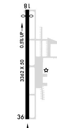
| Runways: | 18/36 |
| Longest Runway: | 18/36 is 3360 ft (1024 m) long |
| Runways with an Instrument Approach: |
1C5 Airport Runway Details
| Runway 18/36 | 3360 ft x 75 ft (1024 m x 23 m) | |
| Surface: | Asphalt - Good condition - No special surface treatment | |
| Runway Edge Lights: | Medium Intensity | |
Runway Weight Bearing Capacity (in thousands of pounds) |
||
| Single Wheel Landing Gear: | 12.5 | |
Runway 18 |
Runway 36 |
|
Elevation: |
674.9 | 657.0 |
Latitude: |
41-42-01.8747N | 41-41-28.6938N |
Longitude: |
088-07-46.7968W | 088-07-45.5199W |
|
Runway True Alignment: |
178 | 358 |
Glide Path Angle: |
0.0 degrees | 0.0 degrees |
Traffic Pattern: |
Left | Left |
Runway Markings Type: |
Nonprecision Instrument | Nonprecision Instrument |
Runway Markings Condition: |
Fair | Fair |
Object at End: |
TREE | TREE |
Object Height: |
34 | 25 |
Distance from End: |
697 | 600 |
Object Centerline Offset: |
126 ft. right of centerline | 16 ft. right of centerline |
Services
Airframe Repair: |
Major |
Powerplant Repair: |
Major |
Bottled Oxygen: |
None |
Bulk Oxygen: |
None |
Fuel Available: |
100LL |
Landing Fees: |
No |
Parking: |
Hangars and tiedowns available |
Maps & Diagrams
1C5 Sectional
Flight Planning
at skyvector.com
at skyvector.com