Location
Latitude: |
43-03-09.7000N (43.052694) |
Longitude: |
073-21-47.3000W (-73.363139) |
Elevation: |
510.0 feet MSL (155 m MSL) |
Magnetic Variation: |
13.3 W (as of April 2024 from WMM2020 model) |
Time Zone: |
UTC -5.0 (Standard Time) UTC -4.0 (Daylight Savings Time) |
From City: |
02 N.M. N of Cambridge, New York |
Found On: |
New York Chart |
FAA Region: |
AEA |
Contacts
Manager: |
Privately owned: |
| GEORGE GRACEY 6 MYRTLE AVE. CAMBRIDGE, NY 12816 (518) 727-6509 |
DEAN CHAPIN PO BOX 144 CAMBRIDGE, NY 12816 (518) 677-8866 |
Operations
Airport Status: |
Operational |
Facility Use: |
Public |
Type: |
Airport |
Activation Date: |
07/1966 |
Control tower: |
No |
Attendance (Months/Days/Hours): |
Months/Days/Hours Unattended |
Boundary ARTCC: |
ZBW (Boston) |
Responsible ARTCC: |
ZBW (Boston) |
Segmented Circle Indicator: |
No |
Traffic Pattern Altitude (MSL): |
1510 feet (460 m) |
NOTAMs Facility: |
BTV |
NOTAM-D Service: |
Yes |
Civil/Military Joint Use: |
No |
Based Aircraft
| Single Engine: | 20 |
| Multi Engine: | 1 |
Annual Operations (as of 08/07/2018)
| Total Operations: | 1400 | |
| GA Local: | 1150 | 82.1% |
| GA Itinerant: | 150 | 10.7% |
| Military Aircraft: | 100 | 7.1% |
Communications
| CTAF: | 122.900 |
Fixed Based Operators (FBOs) & Fuel
(Click on a business for detail)
Please help us keep this information up to date. This is a FREE SERVICE just like everything else on Airport Guide! If you see that a business needs to be added, modified, or deleted please fill out our Update Form.
To add, modify, or delete a business click here.
Please help us keep this information up to date. This is a FREE SERVICE just like everything else on Airport Guide! If you see that a business needs to be added, modified, or deleted please fill out our Update Form.
Area Code: 518 |
| Business Name | Frequency | Phone | Fuel Grade |
|---|---|---|---|
| Cambridge Valley Flying Club, Inc.
Update FBO info |
677-8082, -3866 |
Flight Service Stations
| Primary | Alternate | |
| FSS on Field: | N | |
| FSS Name (ID): | Burlington(BTV) | |
| Frequency: | ||
| Toll Free Phone: | 1-800-WX-BRIEF |
Instrument Procedures / Charts
Terminal Procedures are only available for airports in several countries with more being added all the time. If you are looking for a specific country's charts, please send an email to support(at)airportguide.com stating the country name. This will be used to prioritize the implementation.
Navigation Aids (Navaids) near 1B8
| Dist (NM) | ID | Morse Code | Name | Type | Freq | True Hdg | Mag Hdg |
|---|---|---|---|---|---|---|---|
| 3.6 | CAM | _ . _ . . _ _ _ | Cambridge | VOR-DME | 115.00 | 166 | 179 |
| 16.1 | GF | _ _ . . . _ . | Ganse | NDB | 209 | 318 | 331 |
| 20.5 | GFL | _ _ . . . _ . . _ . . | Glens Falls | VORTAC | 110.20 | 327 | 340 |
| 23.2 | VWD | . . . _ . _ _ _ . . | Mount Snow | NDB | 224 | 108 | 121 |
| 26.6 | ALB | . _ . _ . . _ . . . | Albany | VORTAC | 115.30 | 226 | 239 |
| 27.5 | ALB | . _ . _ . . _ . . . | Albany | VOT | 108.20 | 227 | 240 |
| 27.7 | HEU | . . . . . . . _ | Hunter | NDB | 356 | 244 | 257 |
| 33.7 | RUT | . _ . . . _ _ | Rutland | DME | 111 | 32 | 45 |
| 36.4 | SXD | . . . _ . . _ _ . . | Springfield | NDB | 265 | 68 | 82 |
| 39.3 | R | . _ . | Chitt | FAN MARKER | 27 | 41 | |
| 42.6 | JJH | . _ _ _ . _ _ _ . . . . | Johnstown | NDB | 523 | 266 | 279 |
| 43.0 | DYO | _ . . _ . _ _ _ _ _ | Smuto | NDB | 221 | 24 | 38 |
| 47.4 | CNH | _ . _ . _ . . . . . | Claremont | NDB | 233 | 66 | 80 |
| 49.2 | CTR | _ . _ . _ . _ . | Chester | VOR-DME | 115.10 | 158 | 171 |
| 49.6 | EEN | . . _ . | Keene | DME | 109.4 | 107 | 121 |
| 49.6 | IVV | . . . . . _ . . . _ | White River | NDB | 379 | 51 | 65 |
| 50.5 | PFH | . _ _ . . . _ . . . . . | Philmont | NDB | 272 | 198 | 211 |
| 52.2 | GBR | _ _ . _ . . . . _ . | Great Barrington | NDB | 395 | 181 | 194 |
| 55.6 | ORE | _ _ _ . _ . . | Orange | NDB | 205 | 121 | 135 |
| 60.6 | BAF | _ . . . . _ . . _ . | Barnes | VORTAC | 113.00 | 151 | 164 |
Nearby Airports with Fuel
Notices to Airmen (NOTAMS)
Remarks
| A110-1 | LGTD 5 FT FENCE AT RY 25 END. |
| A110-2 | 14 FT HANGAR, 0 FT FROM RWY END, 66 FT RT. |
| A110-3 | FOR CD CTC ALBANY APCH AT 518-862-2299. |
| A31-05/23 | LENGTH REDUCED ON SOUTH END |
| A32-05/23 | WIDTH VARIES FROM 65'-80' BASED ON MOWING |
| A33-05/23 | & RY 07/25 SOFT & WET MAR-JUN. |
| A42-07 | RYS 07 & 25 DSPLCD THLDS MKD WITH STRIPED CYLINDERS. |
| A57-07 | 23 FT RR, 125 FT LT, CROSSES EXTND RWY CNTRLN 260 FT FROM RWY END. 9:1 SLOPE TO DISP THRSHLD. |
| A57-25 | 21:1 SLOPE TO DSPLCD THLD. |
| E111 | PRVDD THLDS ARE DSPLCD TO PRVD 20:1 APCH SLOPES. |
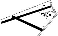
Runways
Runway Summary
| Runways: | 05/23 07/25 |
| Longest Runway: | 05/23 is 2130 ft (649 m) long |
| Runways with an Instrument Approach: |
1B8 Airport Runway Details
| Runway 05/23 | 2130 ft x 65 ft (649 m x 20 m) | |
| Runway Length Source: | STATE as of 09/06/2006 | |
| Surface: | Turf - Good condition - No special surface treatment | |
Runway 05 |
Runway 23 |
|
Elevation: |
508.0 | 510.0 |
Latitude: |
43-03-00.7613N | 43-03-18.6483N |
Longitude: |
073-21-54.8147W | 073-21-39.6989W |
|
Runway True Alignment: |
032 | 212 |
Glide Path Angle: |
0.0 degrees | 0.0 degrees |
Traffic Pattern: |
Left | Left |
Object at End: |
TREE | TREES |
Object Height: |
72 | 89 |
Distance from End: |
494 | 42 |
Object Centerline Offset: |
123 ft. left of centerline | 113 ft. right of centerline |
| Runway 07/25 | 2100 ft x 63 ft (640 m x 19 m) | |
| Surface: | Turf - Good condition - No special surface treatment | |
Runway 07 |
Runway 25 |
|
Glide Path Angle: |
0.0 degrees | 0.0 degrees |
Runway Markings Type: |
Nonstandard (other than numbers only) | Nonstandard (other than numbers only) |
Object at End: |
RR | ROAD |
Object Height: |
34 | 52 |
Distance from End: |
41 | 132 |
Object Centerline Offset: |
123 ft. left of centerline | 113 ft. right of centerline |
REIL: |
No | |
Displaced Threshold: |
222 | 306 |
Services
Airframe Repair: |
Major |
Powerplant Repair: |
Major |
Bottled Oxygen: |
None |
Bulk Oxygen: |
None |
Fuel Available: |
100LL |
Landing Fees: |
No |
Parking: |
Hangars and tiedowns available |
Maps & Diagrams
1B8 Sectional
Flight Planning
at skyvector.com
at skyvector.com