Location
Latitude: |
41-00-31.0310N (41.00862) |
Longitude: |
074-44-16.9220W (-74.738034) |
Elevation: |
582.7 feet MSL (178 m MSL) |
Magnetic Variation: |
12.3 W (as of April 2024 from WMM2020 model) |
Time Zone: |
UTC -5.0 (Standard Time) UTC -4.0 (Daylight Savings Time) |
From City: |
03 N.M. N of Andover, New Jersey |
Found On: |
New York Chart |
FAA Region: |
AEA |
Contacts
Manager: |
Publicly owned: |
| JOHN T FLYNTZ AEROFLEX-ANDOVER ARPT, P.O. BOX 709 ANDOVER, NJ 07821 973-786-5100 |
NJ ST FOREST FIRE SVC PO BOX 404 TRENTON, NJ 08625 609-292-2977 |
Operations
Airport Status: |
Operational |
Facility Use: |
Public |
Type: |
Airport |
Control tower: |
No |
Attendance (Months/Days/Hours): |
Months/Days/Hours ALL/ALL/0900-1700 |
Boundary ARTCC: |
ZNY (New York) |
Responsible ARTCC: |
ZNY (New York) |
Lighting Schedule: |
SEE RMK |
Segmented Circle Indicator: |
Yes |
Traffic Pattern Altitude (MSL): |
1583 feet (482 m) |
NOTAMs Facility: |
12N |
NOTAM-D Service: |
Yes |
International Airport of Entry: |
No |
Customs Landing Rights: |
No |
Military Landing Rights: |
No |
Civil/Military Joint Use: |
No |
Based Aircraft
| Single Engine: | 35 |
| Multi Engine: | 1 |
| GA Helicopters: | 1 |
Annual Operations (as of 12/31/2022)
| Total Operations: | 32550 | |
| GA Local: | 18750 | 57.6% |
| GA Itinerant: | 13800 | 42.4% |
Communications
| CTAF: | 122.800 |
| Unicom: | 122.800 |
| Approach: | NEW YORK 127.6 127.6 |
| Departure: | NEW YORK 127.6 127.6 |
| ASOS: | (917-786-7221) |
Fixed Based Operators (FBOs) & Fuel
(Click on a business for detail)
Please help us keep this information up to date. This is a FREE SERVICE just like everything else on Airport Guide! If you see that a business needs to be added, modified, or deleted please fill out our Update Form.
To add, modify, or delete a business click here.
Please help us keep this information up to date. This is a FREE SERVICE just like everything else on Airport Guide! If you see that a business needs to be added, modified, or deleted please fill out our Update Form.
Area Code: 201 |
| Business Name | Frequency | Phone | Fuel Grade |
|---|---|---|---|
| Aeroflex Andover Airport
Update FBO info |
Unicom 122.8 | 973-786-5100 | 100LL |

|
Unknown | 100LL - 4.80 USD per gallon on 11/1/10 |
Pumps Requiring Line Service |
Flight Service Stations
| Primary | Alternate | |
| FSS on Field: | N | |
| FSS Name (ID): | Millville(MIV) | |
| Frequency: | ||
| Toll Free Phone: | 1-800-WX-BRIEF |
Instrument Procedures / Charts
FAA Terminal Procedures valid from 0901Z 03/21/24 to 0901Z 04/18/24.
There are various types of charts available for an airport. They are listed in the Page Type column. Here is a legend for those types:
APD - Airport Diagram
DP - Departure Procedure Charts
HOT - Hot Spots
IAP - Instrument Approach Procedure Charts
MIN - Minimums
STAR - Standard Terminal Arrival Charts
| Page Type | Page Name | Volume | Action Since Last Cycle |
|---|---|---|---|
| IAP | RNAV (GPS) RWY 03 | NE-2 | |
| IAP | VOR-A | NE-2 | |
| MIN | ALTERNATE MINIMUMS | NE-2 | |
| MIN | TAKEOFF MINIMUMS | NE-2 |
Terminal Procedures are only available for airports in several countries with more being added all the time. If you are looking for a specific country's charts, please send an email to support(at)airportguide.com stating the country name. This will be used to prioritize the implementation.
Navigation Aids (Navaids) near 12N
| Dist (NM) | ID | Morse Code | Name | Type | Freq | True Hdg | Mag Hdg |
|---|---|---|---|---|---|---|---|
| 6.0 | STW | . . . _ . _ _ | Stillwater | VOR-DME | 109.60 | 262 | 274 |
| 9.7 | SAX | . . . . _ _ . . _ | Sparta | VORTAC | 115.70 | 68 | 80 |
| 13.2 | BWZ | _ . . . . _ _ _ _ . . | Broadway | VOR-DME | 114.20 | 196 | 208 |
| 21.3 | CAT | _ . _ . . _ _ | Chatham | NDB | 254 | 138 | 150 |
| 25.0 | HUO | . . . . . . _ _ _ _ | Huguenot | VOR-DME | 116.10 | 15 | 27 |
| 25.5 | SBJ | . . . _ . . . . _ _ _ | Solberg | VOR-DME | 112.90 | 180 | 192 |
| 30.1 | TE | _ . | Torby | NDB | 214 | 113 | 125 |
| 31.0 | EWR | . . _ _ . _ . | Maryann | FAN MARKER | 126 | 138 | |
| 32.1 | TEB | _ . _ . . . | Teterboro | VOR-DME | 108.40 | 107 | 119 |
| 32.4 | EWR | . . _ _ . _ . | Newark | DME | 113.75 | 128 | 140 |
| 36.7 | FJC | . . _ . . _ _ _ _ . _ . | Allentown | VORTAC | 117.50 | 242 | 254 |
| 36.7 | SW | . . . . _ _ | Neely | NDB | 335 | 38 | 50 |
| 41.7 | LGA | . _ . . _ _ . . _ | La Guardia | VOR-DME | 113.10 | 108 | 121 |
| 43.3 | UKT | . . _ _ . _ _ | Quakertown | NDB | 208 | 216 | 228 |
| 43.8 | LHY | . _ . . . . . . _ . _ _ | Lake Henry | VORTAC | 110.80 | 310 | 322 |
| 44.1 | SKU | . . . _ . _ . . _ | Stanwyck | NDB | 261 | 44 | 57 |
| 44.1 | SKU | . . . _ . _ . . _ | Stanwyck | FAN MARKER | 44 | 57 | |
| 45.1 | CRI | _ . _ . . _ . . . | Canarsie | VOR-DME | 112.30 | 121 | 133 |
| 45.8 | MS | _ _ . . . | Monga | NDB | 359 | 353 | 365 |
| 45.8 | LVZ | . _ . . . . . _ _ _ . . | Wilkes-Barre | VORTAC | 111.60 | 290 | 302 |
Nearby Airports with Fuel
Notices to Airmen (NOTAMS)
Remarks
| A110*G | THIS AIRPORT HAS BEEN SURVEYED BY THE NATIONAL GEODETIC SURVEY. |
| A110-10 | AVOID OVERFLYING LAKE LENAPE WHILE ON DOWNWIND. |
| A110-11 | FOR CD CTC NEW YORK APCH AT 800-645-3206. |
| A110-12 | DEER & BIRDS ON & INVOF ARPT. |
| A110-2 | DIRT SVC ROAD TO TRML AREA IN FRONT OF RWY 03 THLD. |
| A110-3 | PARALLEL TURF RWY RESTRICTED USE ONLY. |
| A110-4 | ARPT RESTRICTED TO APCH CATAGORY A ACFT ONLY. |
| A110-6 | NO TGL. |
| A110-7 | RY 03/21 LAKES AT BOTH APCH ENDS. |
| A110-8 | NOISE ABATEMENT PROCEDURES IN EFFECT. CTC AMGR 973-786-5100. |
| A110-9 | PPR REQUIRED FOR NIGHT TRANSIENTS CTC AMGR 973-786-5100. |
| A58-03 | RWY 03 80 FT TREE AT RWY END 167 FT LEFT OF CNTRLN. |
| A58-21 | RY 21 15 FT ROAD AT THLD. |
| A81-APT | ACTVT MIRL RWY 03/21 - CTAF. |
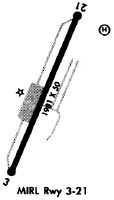
Runways
Runway Summary
| Runways: | 03/21 |
| Longest Runway: | 03/21 is 1981 ft (604 m) long |
| Runways with an Instrument Approach: |
12N Airport Runway Details
| Runway 03/21 | 1981 ft x 50 ft (604 m x 15 m) | |
| Surface: | Asphalt - Good condition - No special surface treatment | |
| Runway Edge Lights: | Medium Intensity | |
Runway 03 |
Runway 21 |
|
Elevation: |
582.4 | 582.5 |
Latitude: |
41-00-21.9160N | 41-00-40.1460N |
Longitude: |
074-44-21.6280W | 074-44-12.2160W |
|
Runway True Alignment: |
021 | 201 |
Glide Path Angle: |
0.0 degrees | 0.0 degrees |
Traffic Pattern: |
Right | Left |
Runway Markings Type: |
Nonprecision Instrument | Basic |
Runway Markings Condition: |
Good | Good |
Object at End: |
TREES | TREE |
Object Height: |
108 | 64 |
Distance from End: |
504 | 580 |
Object Centerline Offset: |
256 ft. left of centerline | 150 ft. right of centerline |
Services
Airframe Repair: |
Major |
Powerplant Repair: |
Major |
Bottled Oxygen: |
None |
Bulk Oxygen: |
None |
Fuel Available: |
100LL, Jet A |
Landing Fees: |
Yes |
Parking: |
Hangars and tiedowns available |
Maps & Diagrams
12N Sectional
Flight Planning
at skyvector.com
at skyvector.com