Location
Latitude: |
41-49-57.5000N (41.832639) |
Longitude: |
073-52-34.2000W (-73.876167) |
Elevation: |
450.0 feet MSL (137 m MSL) |
Magnetic Variation: |
12.9 W (as of April 2024 from WMM2020 model) |
Time Zone: |
UTC -5.0 (Standard Time) UTC -4.0 (Daylight Savings Time) |
From City: |
03 N.M. SE of Staatsburg, New York |
Found On: |
New York Chart |
FAA Region: |
AEA |
Contacts
Manager: |
Privately owned: |
| MRS AMY L COURT 947 NORTH QUAKER LANE STAATSBURG, NY 12580 845-889-4717 |
AIRHAVEN INC. 947 NORTH QUAKER LANE STAATSBURG, NY 12580 845-889-4717 |
Operations
Airport Status: |
Operational |
Facility Use: |
Public |
Type: |
Airport |
Activation Date: |
04/1958 |
Control tower: |
No |
Attendance (Months/Days/Hours): |
Months/Days/Hours Unattended |
Boundary ARTCC: |
ZNY (New York) |
Responsible ARTCC: |
ZNY (New York) |
Segmented Circle Indicator: |
No |
Traffic Pattern Altitude (MSL): |
1450 feet (442 m) |
NOTAMs Facility: |
ISP |
NOTAM-D Service: |
Yes |
Based Aircraft
| Single Engine: | 1 |
Annual Operations (as of 08/05/2021)
| Total Operations: | 200 | |
| GA Local: | 125 | 62.5% |
| GA Itinerant: | 75 | 37.5% |
Communications
| CTAF: | 122.900 |
Fixed Based Operators (FBOs) & Fuel
(Click on a business for detail)
Please help us keep this information up to date. This is a FREE SERVICE just like everything else on Airport Guide! If you see that a business needs to be added, modified, or deleted please fill out our Update Form.
To add, modify, or delete a business click here.
Please help us keep this information up to date. This is a FREE SERVICE just like everything else on Airport Guide! If you see that a business needs to be added, modified, or deleted please fill out our Update Form.
Area Code: 845 |
| Business Name | Frequency | Phone | Fuel Grade |
|---|---|---|---|
| Steve's Aircraft Service
Update FBO info |
889-4717 |
Flight Service Stations
| Primary | Alternate | |
| FSS on Field: | N | |
| FSS Name (ID): | New York(ISP) | |
| Frequency: | ||
| Toll Free Phone: | 1-800-WX-BRIEF |
Instrument Procedures / Charts
Terminal Procedures are only available for airports in several countries with more being added all the time. If you are looking for a specific country's charts, please send an email to support(at)airportguide.com stating the country name. This will be used to prioritize the implementation.
Navigation Aids (Navaids) near 09N
| Dist (NM) | ID | Morse Code | Name | Type | Freq | True Hdg | Mag Hdg |
|---|---|---|---|---|---|---|---|
| 10.3 | IGN | . . _ _ . _ . | Kingston | VOR-DME | 117.60 | 166 | 179 |
| 12.9 | PWL | . _ _ . . _ _ . _ . . | Pawling | VOR-DME | 114.30 | 106 | 119 |
| 16.0 | PO | . _ _ . _ _ _ | Meier | NDB | 403 | 194 | 207 |
| 19.8 | SKU | . . . _ . _ . . _ | Stanwyck | FAN MARKER | 202 | 215 | |
| 19.8 | SKU | . . . _ . _ . . _ | Stanwyck | NDB | 261 | 202 | 215 |
| 26.1 | SW | . . . . _ _ | Neely | NDB | 335 | 217 | 230 |
| 26.1 | PFH | . _ _ . . . _ . . . . . | Philmont | NDB | 272 | 15 | 28 |
| 29.7 | GBR | _ _ . _ . . . . _ . | Great Barrington | NDB | 395 | 44 | 57 |
| 35.7 | CMK | _ . _ . _ _ _ . _ | Carmel | VOR-DME | 116.60 | 158 | 171 |
| 40.9 | HUO | . . . . . . _ _ _ _ | Huguenot | VOR-DME | 116.10 | 231 | 244 |
| 43.6 | JWE | . _ _ _ . _ _ . | Clera | NDB | 362 | 128 | 141 |
| 44.2 | MS | _ _ . . . | Monga | NDB | 359 | 265 | 278 |
| 49.6 | CTR | _ . _ . _ . _ . | Chester | VOR-DME | 115.10 | 56 | 69 |
| 52.5 | DNY | _ . . _ . _ . _ _ | Delancey | VOR-DME | 112.10 | 293 | 306 |
| 52.5 | BDR | _ . . . _ . . . _ . | Bridgeport | VOT | 109.25 | 139 | 152 |
| 52.6 | BDR | _ . . . _ . . . _ . | Bridgeport | VOR-DME | 108.80 | 139 | 152 |
| 53.4 | BDL | _ . . . _ . . . _ . . | Bradley | VORTAC | 109.00 | 82 | 95 |
| 53.5 | BDL | _ . . . _ . . . _ . . | Bradley | VOT | 111.40 | 83 | 96 |
| 54.6 | ALB | . _ . _ . . _ . . . | Albany | VOT | 108.20 | 2 | 15 |
| 54.7 | SAX | . . . . _ _ . . _ | Sparta | VORTAC | 115.70 | 213 | 226 |
Nearby Airports with Fuel
Notices to Airmen (NOTAMS)
Remarks
| A110-1 | STEEP GRADES & DROP-OFFS LCTD IN RY 02 SAFETY AREA. |
| A110-2 | RY NOT PLOWED IN WINTER. |
| A110-3 | RY 20 HAS +50 FT TREES, 30 FT FROM THLD, 50 FT LEFT. |
| A110-4 | FOR CD CTC NEW YORK APCH AT 516-683-2448. |
| A42-02 | RY 02/20 2 FT PVC REFLECTIVE MARKERS; BLUE MARKERS AT THLD; ALL OTHERS ALONG EDGE ARE WHITE. |
| E111 | MARKERS ARE PLACED AT THE CORNERS OF RWY AND AT INTERVALS OF 400 FT, OR LESS, ALONG ITS LENGTH; WIND DIRECTION INDICATOR IS INSTALLED. |
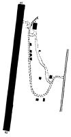
Runways
Runway Summary
| Runways: | 02/20 |
| Longest Runway: | 02/20 is 1863 ft (568 m) long |
| Runways with an Instrument Approach: |
09N Airport Runway Details
| Runway 02/20 | 1863 ft x 75 ft (568 m x 23 m) | |
| Surface: | Turf - Good condition - No special surface treatment | |
Runway 02 |
Runway 20 |
|
Elevation: |
417.0 | 444.0 |
Latitude: |
41-49-48.2955N | 41-50-06.6799N |
Longitude: |
073-52-34.8494W | 073-52-33.5622W |
|
Runway True Alignment: |
003 | 183 |
Glide Path Angle: |
0.0 degrees | 0.0 degrees |
Object at End: |
TREE | TREES |
Object Height: |
61 | 36 |
Distance from End: |
24 | 32 |
Object Centerline Offset: |
45 ft. left of centerline | 41 ft. left of centerline |
Services
Airframe Repair: |
Major |
Powerplant Repair: |
Major |
Bottled Oxygen: |
None |
Bulk Oxygen: |
None |
Fuel Available: |
100LL, Jet A |
Landing Fees: |
No |
Parking: |
Tiedowns available |
Maps & Diagrams
09N Sectional
Flight Planning
at skyvector.com
at skyvector.com