Location
Latitude: |
61-23-40.7400N (61.39465) |
Longitude: |
149-50-32.1700W (-149.842269) |
Elevation: |
78.0 feet MSL (24 m MSL) |
Magnetic Variation: |
14.8 E (as of April 2024 from WMM2020 model) |
Time Zone: |
UTC -9.0 (Standard Time) UTC -8.0 (Daylight Savings Time) |
From City: |
00 N.M. E of Goose Bay, Alaska |
Found On: |
Anchorage Chart |
FAA Region: |
AAL |
Contacts
Manager: |
Publicly owned: |
| KYLER HYLTON 289 INNER SPRINGER LOOP RD. PALMER, AK 99645 907-246-3325 |
ALASKA DOT&PF CENTRAL REGION PO BOX 196900 ANCHORAGE, AK 99519-6900 907-269-0782 |
Operations
Airport Status: |
Operational |
Facility Use: |
Public |
Type: |
Airport |
Activation Date: |
10/1949 |
Control tower: |
No |
Attendance (Months/Days/Hours): |
Months/Days/Hours Unattended |
Boundary ARTCC: |
ZAN (Anchorage) |
Responsible ARTCC: |
ZAN (Anchorage) |
Segmented Circle Indicator: |
Yes |
Traffic Pattern Altitude (MSL): |
1078 feet (329 m) |
NOTAMs Facility: |
ENA |
NOTAM-D Service: |
Yes |
International Airport of Entry: |
No |
Customs Landing Rights: |
No |
Military Landing Rights: |
Yes |
Based Aircraft
Annual Operations (as of 12/31/2019)
| Total Operations: | 5500 | |
| GA Itinerant: | 5500 | 100.0% |
Communications
| CTAF: | 122.900 |
Fixed Based Operators (FBOs) & Fuel
(Click on a business for detail)
Please help us keep this information up to date. This is a FREE SERVICE just like everything else on Airport Guide! If you see that a business needs to be added, modified, or deleted please fill out our Update Form.
To add, modify, or delete a business click here.
Please help us keep this information up to date. This is a FREE SERVICE just like everything else on Airport Guide! If you see that a business needs to be added, modified, or deleted please fill out our Update Form.
Area Code: 907 |
| Business Name | Frequency | Phone | Fuel Grade |
|---|
Flight Service Stations
| Primary | Alternate | |
| FSS on Field: | N | |
| FSS Name (ID): | Kenai(ENA) | |
| Frequency: | ||
| Toll Free Phone: | 1-866-864-1737 |
Instrument Procedures / Charts
Terminal Procedures are only available for airports in several countries with more being added all the time. If you are looking for a specific country's charts, please send an email to support(at)airportguide.com stating the country name. This will be used to prioritize the implementation.
Navigation Aids (Navaids) near Z40
| Dist (NM) | ID | Morse Code | Name | Type | Freq | True Hdg | Mag Hdg |
|---|---|---|---|---|---|---|---|
| 8.6 | EDF | . _ . . . . _ . | Elmendorf | TACAN | 113.40 | 165 | 150 |
| 10.7 | MRI | _ _ . _ . . . | Anchorage | VOT | 111.00 | 180 | 165 |
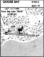
| 11.1 | BGQ | _ . . . _ _ . _ _ . _ | Big Lake | VORTAC | 112.50 | 341 | 326 |
| 14.0 | TED | _ . _ . . | Anchorage | VOR-DME | 113.15 | 194 | 179 |
| 14.4 | ANC | . _ _ . _ . _ . | Anchorage | VOT | 108.40 | 197 | 182 |
| 14.7 | CMQ | _ . _ . _ _ _ _ . _ | Campbell Lake | NDB | 338 | 203 | 188 |
| 54.7 | TKA | _ _ . _ . _ | Talkeetna | VOR-DME | 116.20 | 352 | 337 |
| 56.6 | PEE | . _ _ . . . | Peters Creek | NDB | 305 | 352 | 337 |
| 61.1 | ENA | . _ . . _ | Kenai | VOR-DME | 117.60 | 220 | 205 |
| 62.2 | IWW | . . . _ _ . _ _ | Wildwood | NDB | 379 | 220 | 206 |
| 62.9 | OLT | _ _ _ . _ . . _ | Soldotna | NDB-DME | 346 | 209 | 194 |
Nearby Airports with Fuel
| Dist (NM) | Name (Airport IDs) | True Hdg | Mag Hdg | Fuel Grade |
|---|---|---|---|---|
| 9.7 | Birchwood Airport (PABV BCV) |
82 | 67 | 100LL |
| 10.9 | Merrill Field Airport (MRI PAMR MRI) |
180 | 165 | 100, Jet A |
| 10.9 | Alaska Regional Hospital Heliport (2OK) |
177 | 162 | 100LL, Jet A |
| 13.7 | Wasilla Airport (WWA PAWS IYS) |
39 | 24 | 100LL, Jet A |
| 14.0 | Ted Stevens Anchorage International Airport (ANC PANC ANC) |
198 | 183 | 100, 100LL, Jet A, Jet A-1 |
| 17.0 | Wasilla Lake Seaplane Base (5L6) |
47 | 32 | 100LL |
| 24.7 | Warren 'Bud' Woods Palmer Municipal Airport (PAQ PAAQ PAQ) |
60 | 45 | 100LL, Jet A-1 |
| 56.1 | Talkeetna Airport (TKA PATK TKA) |
352 | 337 | 100LL, Jet A, Jet A+ |
| 64.0 | Kenai Municipal Airport (ENA PAEN ENA) |
220 | 206 | 100LL, Jet A |
| 65.3 | Soldotna Airport (SXQ PASX SXQ) |
212 | 198 | 100LL, Jet A |
Notices to Airmen (NOTAMS)
Remarks
| A110-1 | RWY COND UNMNTD; RCMD VISUAL INSP BFR USE. |
| A110-2 | 808 FT LGTD TWR 11700 FT NNW OF RWY. |
| A110-6 | WX CAMERA AVBL ON INTERNET AT HTTPS://WEATHERCAMS.FAA.GOV |
| A110-7 | LRG MIL LOW ALT OPS INVOF R-2203, GOOSE BAY, BIRCHWOOD & BIG LAKE ARPTS. MIL ACFT MNT MULT CTAF FREQ. SEE CURRENT ANCHORAGE VFR TAC INSERT & CNTR NOTAMS. |
| A42-08 | RWY END MKD WITH THR PANEL. |
| A42-26 | RWY END MKD WITH THR PANEL. |
| A83 | WINDSOCK UNRELBL. |
| A84 | POOR COND. |
Runways
Runway Summary
| Runways: | 08/26 |
| Longest Runway: | 08/26 is 3000 ft (914 m) long |
| Runways with an Instrument Approach: |
Z40 Airport Runway Details
| Runway 08/26 | 3000 ft x 75 ft (914 m x 23 m) | |
| Surface: | Gravel - Fair condition - No special surface treatment | |
Runway 08 |
Runway 26 |
|
Elevation: |
78.0 | 78.0 |
Latitude: |
61-23-41.6200N | 61-23-39.8600N |
Longitude: |
149-51-02.9200W | 149-50-01.4200W |
Glide Path Angle: |
0.0 degrees | 0.0 degrees |
Traffic Pattern: |
Right | Left |
Runway Markings Type: |
Nonstandard (other than numbers only) | Nonstandard (other than numbers only) |
Object at End: |
ROAD | ROAD |
Object Height: |
15 | 15 |
Distance from End: |
0 | 0 |
Object Centerline Offset: |
80 ft. left of centerline | 80 ft. right of centerline |
Services
Airframe Repair: |
Major |
Powerplant Repair: |
Major |
Fuel Available: |
100LL, Jet A |
Landing Fees: |
Yes |
Parking: |
Tiedowns available |
Maps & Diagrams
Z40 Sectional
Flight Planning
at skyvector.com
at skyvector.com