Location
Latitude: |
41-17-50.3070N (41.297308) |
Longitude: |
075-51-08.0760W (-75.852243) |
Elevation: |
543.8 feet MSL (166 m MSL) |
Magnetic Variation: |
11.8 W (as of April 2024 from WMM2020 model) |
Time Zone: |
UTC -5.0 (Standard Time) UTC -4.0 (Daylight Savings Time) |
From City: |
03 N.M. N of Wilkes-Barre, Pennsylvania |
Found On: |
New York Chart |
FAA Region: |
AEA |
Contacts
Manager: |
Publicly owned: |
| JIM SCROBOLA 2001 WYOMING AVE FORTY FORT, PA 18704 570-288-3257 |
COUNTY OF LUZERNE 200 N. RIVER ST. WILKES-BARRE, PA 18071 570-825-1600 |
Operations
Airport Status: |
Operational |
Facility Use: |
Public |
Type: |
Airport |
Control tower: |
No |
Attendance (Months/Days/Hours): |
Months/Days/Hours ALL/ALL/0800-1700 |
Boundary ARTCC: |
ZNY (New York) |
Responsible ARTCC: |
ZNY (New York) |
Lighting Schedule: |
SEE RMK |
Segmented Circle Indicator: |
Yes |
Traffic Pattern Altitude (MSL): |
1544 feet (471 m) |
NOTAMs Facility: |
IPT |
NOTAM-D Service: |
Yes |
International Airport of Entry: |
No |
Customs Landing Rights: |
No |
Military Landing Rights: |
Yes |
Civil/Military Joint Use: |
No |
Based Aircraft
| Single Engine: | 52 |
| Multi Engine: | 3 |
| GA Helicopters: | 1 |
Annual Operations (as of 10/20/2022)
| Total Operations: | 33125 | |
| Air Taxi: | 50 | 0.2% |
| GA Local: | 30000 | 90.6% |
| GA Itinerant: | 3000 | 9.1% |
| Military Aircraft: | 75 | 0.2% |
Communications
| CTAF: | 122.800 |
| Unicom: | 122.800 |
| Approach: | WILKES-BARRE 126.3 126.3 |
| Departure: | WILKES-BARRE 126.3 126.3 |
Fixed Based Operators (FBOs) & Fuel
(Click on a business for detail)
Please help us keep this information up to date. This is a FREE SERVICE just like everything else on Airport Guide! If you see that a business needs to be added, modified, or deleted please fill out our Update Form.
To add, modify, or delete a business click here.
Please help us keep this information up to date. This is a FREE SERVICE just like everything else on Airport Guide! If you see that a business needs to be added, modified, or deleted please fill out our Update Form.
Area Code: 570 |
| Business Name | Frequency | Phone | Fuel Grade |
|---|---|---|---|
| Columbia Aviation, Inc.
Update FBO info |
Unicom 122.8 | 288-7611 | |
| Wyoming Valley Aviation
Update FBO info |
288-3257 | 80, 100LL, Jet A |
Flight Service Stations
| Primary | Alternate | |
| FSS on Field: | N | |
| FSS Name (ID): | Williamsport(IPT) | |
| Frequency: | ||
| Toll Free Phone: | 1-800-WX-BRIEF |
Instrument Procedures / Charts
FAA Terminal Procedures valid from 0901Z 03/21/24 to 0901Z 04/18/24.
There are various types of charts available for an airport. They are listed in the Page Type column. Here is a legend for those types:
APD - Airport Diagram
DP - Departure Procedure Charts
HOT - Hot Spots
IAP - Instrument Approach Procedure Charts
MIN - Minimums
STAR - Standard Terminal Arrival Charts
| Page Type | Page Name | Volume | Action Since Last Cycle |
|---|---|---|---|
| IAP | RNAV (GPS) RWY 07 | NE-4 | |
| IAP | RNAV (GPS) RWY 25 | NE-4 | |
| MIN | TAKEOFF MINIMUMS | NE-4 |
Terminal Procedures are only available for airports in several countries with more being added all the time. If you are looking for a specific country's charts, please send an email to support(at)airportguide.com stating the country name. This will be used to prioritize the implementation.
Navigation Aids (Navaids) near WBW
| Dist (NM) | ID | Morse Code | Name | Type | Freq | True Hdg | Mag Hdg |
|---|---|---|---|---|---|---|---|
| 7.5 | LVZ | . _ . . . . . _ _ _ . . | Wilkes-Barre | VORTAC | 111.60 | 101 | 113 |
| 19.8 | LHY | . _ . . . . . . _ . _ _ | Lake Henry | VORTAC | 110.80 | 57 | 69 |
| 22.9 | HZL | . . . . _ _ . . . _ . . | Hazleton | VOR | 109.40 | 212 | 224 |
| 38.7 | FJC | . . _ . . _ _ _ _ . _ . | Allentown | VORTAC | 117.50 | 152 | 164 |
| 38.7 | PIX | . _ _ . . . _ . . _ | Picture Rocks | NDB | 344 | 268 | 280 |
| 40.2 | MIP | _ _ . . . _ _ . | Milton | VORTAC | 109.20 | 246 | 258 |
| 41.7 | FQM | . . _ . _ _ . _ _ _ | Williamsport | VOR-DME | 114.40 | 273 | 285 |
| 43.6 | ETX | . _ _ . . _ | East Texas | VOR-DME | 110.20 | 169 | 181 |
| 48.0 | STW | . . . _ . _ _ | Stillwater | VOR-DME | 109.60 | 111 | 123 |
| 48.5 | BG | _ . . . _ _ . | Smite | NDB | 332 | 357 | 369 |
| 51.8 | HNK | . . . . _ . _ . _ | Hancock | VOR-DME | 116.80 | 27 | 39 |
| 52.7 | MS | _ _ . . . | Monga | NDB | 359 | 57 | 69 |
| 53.2 | CFB | _ . _ . . . _ . _ . . . | Binghamton | VOR-DME | 112.20 | 346 | 358 |
| 55.4 | BWZ | _ . . . . _ _ _ _ . . | Broadway | VOR-DME | 114.20 | 122 | 134 |
| 55.7 | SEG | . . . . _ _ . | Selinsgrove | VOR-DME | 110.40 | 237 | 249 |
| 56.0 | RAV | . _ . . _ . . . _ | Ravine | VORTAC | 114.60 | 217 | 229 |
| 57.2 | HUO | . . . . . . _ _ _ _ | Huguenot | VOR-DME | 116.10 | 82 | 94 |
| 58.1 | UKT | . . _ _ . _ _ | Quakertown | NDB | 208 | 154 | 166 |
| 60.7 | BZJ | _ . . . _ _ . . . _ _ _ | Bellgrove | NDB | 328 | 211 | 223 |
| 60.9 | SAX | . . . . _ _ . . _ | Sparta | VORTAC | 115.70 | 102 | 114 |
Nearby Airports with Fuel
Notices to Airmen (NOTAMS)
Remarks
| A110-1 | +152 FT TRANSMISSION LINES 6000 FT FROM RWY 25 THLD 585 FT L MKD WITH RED SPHERES. |
| A110-2 | FOR CD CTC WILKES-BARRE APCH AT 570-655-2084. |
| A30-09/27 | RWY 09/27 CLSD WINTER MONTHS. |
| A31-09/27 | RWY 09/27 FIRST 544 FT RWY 27 ASPH, RMNDR TURF. |
| A42-09 | RWY 09/27 MKD WITH 3 FT WHITE CONES. RWY 09; DSPLCD THLD MKD WITH THREE WHITE CONES EACH SIDE. |
| A57-09 | APCH RATIO 18:1 TO DTHR. |
| A81-APT | ACTVT PAPI RWY 07/25; MIRL RWY 07/25 - CTAF. RWY 07/25 PRESET LOW INTST TO ACTVT HIGHER INTST - CTAF. |
| A81-BCN | ACTVT ROTG BCN - CTAF. |
| E111 | EXISTED PRIOR TO 1959. |
Runways
Runway Summary
| Runways: | 07/25 09/27 |
| Longest Runway: | 07/25 is 3375 ft (1029 m) long |
| Runways with an Instrument Approach: |
WBW Airport Runway Details
| Runway 07/25 | 3375 ft x 75 ft (1029 m x 23 m) | |
| Runway Length Source: | 3RD PARTY SURVEY as of 07/16/2019 | |
| Surface: | Asphalt - Good condition - No special surface treatment | |
| Runway Edge Lights: | Medium Intensity | |
Runway 07 |
Runway 25 |
|
Elevation: |
543.8 | 542.9 |
Latitude: |
41-17-39.9268N | 41-17-59.7218N |
Longitude: |
075-51-22.1427W | 075-50-46.5564W |
|
Runway True Alignment: |
054 | 234 |
Glide Path Angle: |
4.0 degrees | 3.8 degrees |
Traffic Pattern: |
Left | |
Runway Markings Type: |
Nonprecision Instrument | Nonprecision Instrument |
Runway Markings Condition: |
Good | Good |
Object at End: |
TREE | |
Object Height: |
118 | |
Distance from End: |
2289 | |
Object Centerline Offset: |
528 ft. right of centerline | |
Visual Glide Slope Indicators: |
2-Light PAPI On Left Side Of Runway | 2-Light PAPI On Left Side Of Runway |
REIL: |
No | No |
Threshold Crossing Height: |
40 | 40 |
| Runway 09/27 | 2193 ft x 100 ft (668 m x 30 m) | |
| Runway Length Source: | 3RD PARTY SURVEY as of 07/16/2019 | |
| Surface: | Asphalt - Good condition - No special surface treatment | |
Runway 09 |
Runway 27 |
|
Elevation: |
541.2 | 542.5 |
Latitude: |
41-17-48.6459N | 41-17-53.4528N |
Longitude: |
075-51-27.8175W | 075-50-59.8034W |
|
Runway True Alignment: |
077 | 257 |
Glide Path Angle: |
0.0 degrees | 0.0 degrees |
Traffic Pattern: |
Left | |
Runway Markings Condition: |
Good | Good |
Object at End: |
TREES | |
Object Height: |
104 | |
Distance from End: |
1241 | |
Object Centerline Offset: |
528 ft. right of centerline | |
Threshold Elevation: |
541.1 | |
Displaced Threshold: |
672 | |
Threshold Latitude: |
41-17-50.1172N | |
Threshold Longitude: |
075-51-19.2392W |
Services
Airframe Repair: |
Minor |
Powerplant Repair: |
Minor |
Bottled Oxygen: |
None |
Bulk Oxygen: |
None |
Fuel Available: |
100LL, Jet A |
Landing Fees: |
Yes |
Parking: |
Hangars and tiedowns available |
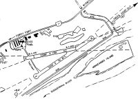
Maps & Diagrams
WBW Sectional
Flight Planning
at skyvector.com
at skyvector.com