Location
Latitude: |
63-30-57.5000N (63.515972) |
Longitude: |
162-16-40.8000W (-162.278) |
Elevation: |
19.4 feet MSL (6 m MSL) |
Magnetic Variation: |
9.5 E (as of April 2024 from WMM2020 model) |
Time Zone: |
UTC -9.0 (Standard Time) UTC -8.0 (Daylight Savings Time) |
From City: |
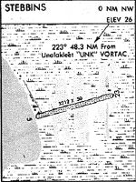
00 N.M. NW of Stebbins, Alaska |
Found On: |
Bethel Chart |
FAA Region: |
AAL |
Contacts
Manager: |
Publicly owned: |
| JOHN WILSON PO BOX 192 UNALAKLEET, AK 99684 (907) 625-1025 |
ALASKA DOT&PF NORTHERN REGION 2301 PEGER RD, 2301 PEGER RD FAIRBANKS, AK 99709 907-451-2200 |
Operations
Airport Status: |
Operational |
Facility Use: |
Public |
Type: |
Airport |
Activation Date: |
07/1964 |
Control tower: |
No |
Attendance (Months/Days/Hours): |
Months/Days/Hours Unattended |
Boundary ARTCC: |
ZAN (Anchorage) |
Responsible ARTCC: |
ZAN (Anchorage) |
Lighting Schedule: |
SEE RMK |
Segmented Circle Indicator: |
Yes |
Traffic Pattern Altitude (MSL): |
1019 feet (311 m) |
NOTAMs Facility: |
OME |
NOTAM-D Service: |
Yes |
Military Landing Rights: |
Yes |
Based Aircraft
Annual Operations (as of 12/31/2022)
| Total Operations: | 500 | |
| Air Taxi: | 500 | 100.0% |
Communications
| CTAF: | 122.800 |
| Unicom: | 122.800 |
Fixed Based Operators (FBOs) & Fuel
(Click on a business for detail)
Please help us keep this information up to date. This is a FREE SERVICE just like everything else on Airport Guide! If you see that a business needs to be added, modified, or deleted please fill out our Update Form.
To add, modify, or delete a business click here.
Please help us keep this information up to date. This is a FREE SERVICE just like everything else on Airport Guide! If you see that a business needs to be added, modified, or deleted please fill out our Update Form.
Area Code: 907 |
| Business Name | Frequency | Phone | Fuel Grade |
|---|
Flight Service Stations
| Primary | Alternate | |
| FSS on Field: | ||
| FSS Name (ID): | Nome(OME) | Fairbanks (FAI) |
| Frequency: | ||
| Toll Free Phone: | 1-800-478-8400 | 1-866-248-6516 |
Instrument Procedures / Charts
Terminal Procedures are only available for airports in several countries with more being added all the time. If you are looking for a specific country's charts, please send an email to support(at)airportguide.com stating the country name. This will be used to prioritize the implementation.
Navigation Aids (Navaids) near WBB
| Dist (NM) | ID | Morse Code | Name | Type | Freq | True Hdg | Mag Hdg |
|---|---|---|---|---|---|---|---|
| 45.5 | JNR | . _ _ _ _ . . _ . | North River | NDB | 382 | 58 | 48 |
| 48.0 | UNK | . . _ _ . _ . _ | Unalakleet | VOR-DME | 116.90 | 61 | 51 |
| 71.0 | OAY | _ _ _ . _ _ . _ _ | Norton Bay | NDB | 263 | 4 | 355 |
| 71.0 | MOS | _ _ _ _ _ . . . | Moses Point | VOR-DME | 116.30 | 4 | 355 |
| 74.2 | ENM | . _ . _ _ | Emmonak | VOR-DME | 117.80 | 234 | 225 |
| 77.4 | ANV | . _ _ . . . . _ | Anvik | NDB | 365 | 131 | 121 |
| 90.1 | KKA | _ . _ _ . _ . _ | Koyuk | NDB-DME | 299 | 18 | 8 |
| 91.6 | SMA | . . . _ _ . _ | St Marys | NDB | 230 | 197 | 188 |
| 97.5 | OME | _ _ _ _ _ . | Nome | VOR-DME | 115.00 | 307 | 298 |
| 99.1 | FDV | . . _ . _ . . . . . _ | Fort Davis | NDB | 529 | 307 | 298 |
Nearby Airports with Fuel
| Dist (NM) | Name (Airport IDs) | True Hdg | Mag Hdg | Fuel Grade |
|---|
Notices to Airmen (NOTAMS)
Remarks
| A110-1 | RY CONDITIONS NOT MONITORED; RECOMMEND VISUAL INSPECTION PRIOR TO LANDING. |
| A30-05/23 | RY FLOODS DURING BREAKUP. |
| A81-APT | ACTVT MIRL RY 05/23 - CTAF. |
| E111 | ESTABD PRIOR TO 1959. |
Runways
Runway Summary
| Runways: | 05/23 |
| Longest Runway: | 05/23 is 2999 ft (914 m) long |
| Runways with an Instrument Approach: |
WBB Airport Runway Details
| Runway 05/23 | 2999 ft x 60 ft (914 m x 18 m) | |
| Runway Length Source: | 3RD PARTY SURVEY as of 09/12/2010 | |
| Surface: | Gravel - Good condition - No special surface treatment | |
| Runway Edge Lights: | Medium Intensity | |
Runway 05 |
Runway 23 |
|
Elevation: |
17.9 | 15.6 |
Latitude: |
63-30-51.0849N | 63-31-03.8931N |
Longitude: |
162-17-10.6120W | 162-16-11.0411W |
|
Runway True Alignment: |
064 | 244 |
Glide Path Angle: |
0.0 degrees | 0.0 degrees |
Traffic Pattern: |
Right | Left |
Object at End: |
HILL | |
Object Height: |
38 | |
Distance from End: |
1226 | |
Object Centerline Offset: |
150 ft. right of centerline |
Services
Airframe Repair: |
None |
Powerplant Repair: |
None |
Bottled Oxygen: |
None |
Bulk Oxygen: |
None |
Landing Fees: |
No |
Maps & Diagrams
WBB Sectional
Flight Planning
at skyvector.com
at skyvector.com