Location
Latitude: |
63-19-51.7445N (63.33104) |
Longitude: |
149-07-43.8100W (-149.128836) |
Elevation: |
2409.0 feet MSL (734 m MSL) |
Magnetic Variation: |
15.1 E (as of April 2024 from WMM2020 model) |
Time Zone: |
UTC -9.0 (Standard Time) UTC -8.0 (Daylight Savings Time) |
From City: |
00 N.M. N of Summit, Alaska |
Found On: |
Anchorage Chart |
FAA Region: |
AAL |
Contacts
Manager: |
Publicly owned: |
| JASON LUDINGTON 2301 PEGER ROAD FAIRBANKS, AK 99709 907-451-5280 |
ALASKA DOT&PF NORTHERN REGION 2301 PEGER RD, 2301 PEGER RD FAIRBANKS, AK 99701 907-451-2200 |
Operations
Airport Status: |
Operational |
Facility Use: |
Public |
Type: |
Airport |
Activation Date: |
08/1947 |
Control tower: |
No |
Attendance (Months/Days/Hours): |
Months/Days/Hours Unattended |
Boundary ARTCC: |
ZAN (Anchorage) |
Responsible ARTCC: |
ZAN (Anchorage) |
Segmented Circle Indicator: |
Yes |
Traffic Pattern Altitude (MSL): |
3409 feet (1039 m) |
NOTAMs Facility: |
ENA |
NOTAM-D Service: |
Yes |
International Airport of Entry: |
No |
Customs Landing Rights: |
No |
Military Landing Rights: |
Yes |
Civil/Military Joint Use: |
No |
Based Aircraft
Annual Operations (as of 12/31/2019)
| Total Operations: | 1054 | |
| Air Taxi: | 400 | 38.0% |
| GA Local: | 400 | 38.0% |
| GA Itinerant: | 250 | 23.7% |
| Military Aircraft: | 4 | 0.4% |
Communications
| CTAF: | 122.900 |
Fixed Based Operators (FBOs) & Fuel
(Click on a business for detail)
Please help us keep this information up to date. This is a FREE SERVICE just like everything else on Airport Guide! If you see that a business needs to be added, modified, or deleted please fill out our Update Form.
To add, modify, or delete a business click here.
Please help us keep this information up to date. This is a FREE SERVICE just like everything else on Airport Guide! If you see that a business needs to be added, modified, or deleted please fill out our Update Form.
Area Code: 907 |
| Business Name | Frequency | Phone | Fuel Grade |
|---|
Flight Service Stations
| Primary | Alternate | |
| FSS on Field: | ||
| FSS Name (ID): | Kenai(ENA) | |
| Frequency: | ||
| Toll Free Phone: | 1-866-864-1737 |
Instrument Procedures / Charts
Terminal Procedures are only available for airports in several countries with more being added all the time. If you are looking for a specific country's charts, please send an email to support(at)airportguide.com stating the country name. This will be used to prioritize the implementation.
Navigation Aids (Navaids) near UMM
| Dist (NM) | ID | Morse Code | Name | Type | Freq | True Hdg | Mag Hdg |
|---|---|---|---|---|---|---|---|
| 1.2 | UMM | . . _ _ _ _ _ | Summit | NDB | 326 | 182 | 167 |
| 65.6 | PEE | . _ _ . . . | Peters Creek | NDB | 305 | 204 | 189 |
| 67.5 | TKA | _ _ . _ . _ | Talkeetna | VOR-DME | 116.20 | 203 | 188 |
| 72.9 | ICW | . . _ . _ . . _ _ | Ice Pool | NDB | 525 | 1 | 346 |
| 75.6 | ENN | . _ . _ . | Nenana | VORTAC | 115.80 | 1 | 346 |
| 91.2 | MHM | _ _ . . . . _ _ | Minchumina | NDB | 227 | 292 | 278 |
| 92.9 | FAI | . . _ . . _ . . | Fairbanks | VORTAC | 108.60 | 17 | 2 |
| 95.7 | EIL | . . . . _ . . | Eielson | TACAN | 115.10 | 33 | 18 |
| 99.4 | BIG | _ . . . . . _ _ . | Big Delta | VORTAC | 114.90 | 64 | 48 |
Nearby Airports with Fuel
| Dist (NM) | Name (Airport IDs) | True Hdg | Mag Hdg | Fuel Grade |
|---|---|---|---|---|
| 5.9 | Cantwell Airport (PATW TTW) |
52 | 37 | 100LL |
| 66.1 | Talkeetna Airport (TKA PATK TKA) |
203 | 188 | 100LL, Jet A, Jet A+ |
| 73.0 | Nenana Municipal Airport (ENN PANN ENN) |
1 | 346 | 100LL, Jet A |
| 95.1 | Fairbanks International Airport (FAI PAFA FAI) |
19 | 3 | 100LL, Jet A-1 |
| 97.1 | Bradley Sky-Ranch Airport (95Z) |
27 | 11 | 100LL |
Notices to Airmen (NOTAMS)
Remarks
| A110-1 | RWY SUBJ TO CROSSWINDS. |
| A110-2 | RECOMMEND VISUAL INSPECTION PRIOR TO LANDING. |
| A110-5 | NO WINTER MAINTENANCE. |
| A110-6 | WX CAMERA AVBL ON INTERNET AT HTTPS://WEATHERCAMS.FAA.GOV |
| A33-03/21 | BRUSH UP TO 4 FT HIGH GROWING ON RWY SURFACE. |
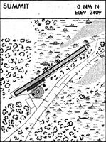
Runways
Runway Summary
| Runways: | 03/21 |
| Longest Runway: | 03/21 is 3814 ft (1163 m) long |
| Runways with an Instrument Approach: |
UMM Airport Runway Details
| Runway 03/21 | 3814 ft x 80 ft (1163 m x 24 m) | |
| Runway Length Source: | FAA as of 06/10/2014 | |
| Surface: | Gravel - Good condition - No special surface treatment | |
Runway 03 |
Runway 21 |
|
Elevation: |
2409.0 | |
Latitude: |
63-19-41.4500N | 63-20-02.0390N |
Longitude: |
149-08-18.7400W | 149-07-08.8800W |
|
Runway True Alignment: |
057 | 237 |
Glide Path Angle: |
0.0 degrees | 0.0 degrees |
Traffic Pattern: |
Left | Left |
Object at End: |
BRUSH | BRUSH |
Object Height: |
7 | 5 |
Distance from End: |
0 | 0 |
Object Centerline Offset: |
54 ft. left of centerline | 55 ft. left and right of centerline |
Services
Airframe Repair: |
None |
Powerplant Repair: |
None |
Bottled Oxygen: |
None |
Bulk Oxygen: |
None |
Fuel Available: |
100LL |
Landing Fees: |
No |
Parking: |
Tiedowns available |
Maps & Diagrams
UMM Sectional
Flight Planning
at skyvector.com
at skyvector.com