Location
Latitude: |
44-54-42.0000N (44.911667) |
Longitude: |
108-26-43.8000W (-108.4455) |
Elevation: |
4093.5 feet MSL (1248 m MSL) |
Magnetic Variation: |
10 E (as of April 2024 from WMM2020 model) |
Time Zone: |
UTC -7.0 (Standard Time) UTC -6.0 (Daylight Savings Time) |
From City: |
02 N.M. N of Cowley/Lovell/Byron, Wyoming |
Found On: |
Billings Chart |
FAA Region: |
ANM |
Contacts
Manager: |
Publicly owned: |
| PAUL THUR P. O. BOX 29, PO BOX 31 BASIN, WY 82410 307-337-8159 |
BIG HORN COUNTY BOX 29 BASIN, WY 82410 307-568-2551 |
Operations
Airport Status: |
Operational |
Facility Use: |
Public |
Type: |
Airport |
Activation Date: |
11/1937 |
Control tower: |
No |
Attendance (Months/Days/Hours): |
Months/Days/Hours IRREG |
Boundary ARTCC: |
ZLC (Salt Lake City) |
Responsible ARTCC: |
ZLC (Salt Lake City) |
Lighting Schedule: |
SEE RMK |
Segmented Circle Indicator: |
Yes |
Traffic Pattern Altitude (MSL): |
5094 feet (1553 m) |
NOTAMs Facility: |
CPR |
NOTAM-D Service: |
Yes |
International Airport of Entry: |
No |
Customs Landing Rights: |
No |
Military Landing Rights: |
Yes |
Civil/Military Joint Use: |
No |
Based Aircraft
| Single Engine: | 13 |
| GA Helicopters: | 1 |
Annual Operations (as of 06/30/2022)
| Total Operations: | 5850 | |
| Air Taxi: | 150 | 2.6% |
| GA Local: | 4200 | 71.8% |
| GA Itinerant: | 1500 | 25.6% |
Communications
| CTAF: | 123.000 |
| Unicom: | 123.000 |
| AWOS-3: | 119.925 (307-548-2560) |
- APCH/DEP CTL SVC PRVDD BY SALT LAKE ARTCC (ZLC) ON FREQS 133.25/285.6(BOYSEN RCAG).
Fixed Based Operators (FBOs) & Fuel
(Click on a business for detail)
Please help us keep this information up to date. This is a FREE SERVICE just like everything else on Airport Guide! If you see that a business needs to be added, modified, or deleted please fill out our Update Form.
To add, modify, or delete a business click here.
Please help us keep this information up to date. This is a FREE SERVICE just like everything else on Airport Guide! If you see that a business needs to be added, modified, or deleted please fill out our Update Form.
Area Code: 307 |
| Business Name | Frequency | Phone | Fuel Grade |
|---|---|---|---|
| Nash Air
Update FBO info |
Unicom 122.8 | 548-6236 | 100ll |
Flight Service Stations
| Primary | Alternate | |
| FSS on Field: | N | |
| FSS Name (ID): | Casper(CPR) | |
| Frequency: | ||
| Toll Free Phone: | 1-800-WX-BRIEF |
Instrument Procedures / Charts
FAA Terminal Procedures valid from 0901Z 03/21/24 to 0901Z 04/18/24.
There are various types of charts available for an airport. They are listed in the Page Type column. Here is a legend for those types:
APD - Airport Diagram
DP - Departure Procedure Charts
HOT - Hot Spots
IAP - Instrument Approach Procedure Charts
MIN - Minimums
STAR - Standard Terminal Arrival Charts
| Page Type | Page Name | Volume | Action Since Last Cycle |
|---|---|---|---|
| IAP | NDB RWY 09 | NW-1 | Deleted |
| IAP | RNAV (GPS) RWY 09 | NW-1 | Changed |
| MIN | TAKEOFF MINIMUMS | NW-1 | Changed |
Terminal Procedures are only available for airports in several countries with more being added all the time. If you are looking for a specific country's charts, please send an email to support(at)airportguide.com stating the country name. This will be used to prioritize the implementation.
Navigation Aids (Navaids) near U68
| Dist (NM) | ID | Morse Code | Name | Type | Freq | True Hdg | Mag Hdg |
|---|---|---|---|---|---|---|---|
| 0.2 | HCY | . . . . _ . _ . _ . _ _ | Cowley | NDB | 257 | 34 | 24 |
| 14.7 | POY | . _ _ . _ _ _ _ . _ _ | Powell | NDB | 344 | 259 | 249 |
| 28.2 | COD | _ . _ . _ _ _ _ . . | Cody | VOR-DME | 111.80 | 231 | 221 |
| 28.6 | GEY | _ _ . . _ . _ _ | Greybull | NDB | 275 | 147 | 137 |
| 54.3 | BIL | _ . . . . . . _ . . | Billings | VORTAC | 114.50 | 352 | 342 |
| 57.4 | BI | _ . . . . . | Saige | NDB | 251 | 349 | 339 |
| 59.0 | SHR | . . . . . . . . _ . | Sheridan | VOR-DME | 113.55 | 93 | 83 |
| 60.7 | RLY | . _ . . _ . . _ . _ _ | Worland | VOR-DME | 114.80 | 159 | 149 |
| 87.1 | BOY | _ . . . _ _ _ _ . _ _ | Boysen Reservoir | VOR-DME | 117.80 | 175 | 165 |
| 93.7 | RPX | . _ . . _ _ . _ . . _ | Roundup | NDB | 362 | 357 | 347 |
| 96.7 | LVM | . _ . . . . . _ _ _ | Livingston | VOR-DME | 116.10 | 300 | 289 |
Nearby Airports with Fuel
Notices to Airmen (NOTAMS)
Remarks
| A110-1 | RWY 16/34 SOFT WHEN WET. |
| A110-2 | REFLECTIVE MKRS MARK ENTRANCE TO TWY & TURNAROUND. |
| A110-3 | FOR CD CTC SALT LAKE ARTCC AT 801-320-2568. |
| A17 | ATNDNC IS PERIODIC AND UNSCHED; PHONE AHEAD FOR SVCS. FOR ATTENDANT AFT HRS CALL 307-250-7215. |
| A3 | 2 MILES N OF COWLEY. |
| A42-16 | 16/34 RWY END DELINATED BY +1 FT CONES. |
| A70-FUEL-10 | 0LL SVC AVBL H24 VIA CREDIT CARD. |
| A75 | PILOT SUPPLIED ROPES PREFERRED FOR TIE DOWNS. |
| A81-APT | ACTVT MIRL RWY 09/27; PAPI RWY 09 & 27; REIL RWY 9 & 27- CTAF. |
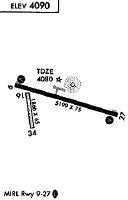
Runways
Runway Summary
| Runways: | 09/27 16/34 |
| Longest Runway: | 09/27 is 5200 ft (1585 m) long |
| Runways with an Instrument Approach: |
U68 Airport Runway Details
| Runway 09/27 | 5200 ft x 75 ft (1585 m x 23 m) | |
| Runway Length Source: | 3RD PARTY SURVEY as of 07/30/2012 | |
| Surface: | Asphalt - Good condition - No special surface treatment | |
| Runway Edge Lights: | Medium Intensity | |
Runway Weight Bearing Capacity (in thousands of pounds) |
||
| Single Wheel Landing Gear: | 12.5 | |
Runway 09 |
Runway 27 |
|
Elevation: |
4083.4 | 4093.5 |
Latitude: |
44-54-50.4818N | 44-54-36.5261N |
Longitude: |
108-27-12.4323W | 108-26-02.9054W |
|
Runway True Alignment: |
106 | 286 |
Glide Path Angle: |
3.0 degrees | 3.0 degrees |
Traffic Pattern: |
Left | Left |
Runway Markings Type: |
Nonprecision Instrument | Nonprecision Instrument |
Runway Markings Condition: |
Good | Good |
Object at End: |
HILL | HILL |
Object Height: |
8 | 91 |
Distance from End: |
315 | 3673 |
Object Centerline Offset: |
90 ft. right of centerline | 40 ft. left of centerline |
Visual Glide Slope Indicators: |
2-Light PAPI On Left Side Of Runway | 2-Light PAPI On Left Side Of Runway |
REIL: |
Yes | Yes |
Threshold Crossing Height: |
40 | 40 |
| Runway 16/34 | 1866 ft x 65 ft (569 m x 20 m) | |
| Runway Length Source: | 3RD PARTY SURVEY as of 07/30/2012 | |
| Surface: | Asphalt - Good condition - No special surface treatment | |
Runway 16 |
Runway 34 |
|
Elevation: |
4080.9 | 4083.2 |
Latitude: |
44-54-46.9550N | 44-54-28.7400N |
Longitude: |
108-27-02.9939W | 108-26-59.0892W |
|
Runway True Alignment: |
172 | 352 |
Glide Path Angle: |
0.0 degrees | 0.0 degrees |
Traffic Pattern: |
Left | Left |
Runway Markings Type: |
None | None |
Runway Markings Condition: |
Good | Good |
Object Centerline Offset: |
90 ft. right of centerline | 40 ft. left of centerline |
Services
Bottled Oxygen: |
None |
Bulk Oxygen: |
None |
Fuel Available: |
100ll Jet A |
Landing Fees: |
No |
Parking: |
Tiedowns available |
Maps & Diagrams
U68 Sectional
Flight Planning
at skyvector.com
at skyvector.com