Location
Latitude: |
42-47-50.3400N (42.797317) |
Longitude: |
112-49-30.6720W (-112.825187) |
Elevation: |
4419.0 feet MSL (1347 m MSL) |
Magnetic Variation: |
11.6 E (as of April 2024 from WMM2020 model) |
Time Zone: |
UTC -7.0 (Standard Time) UTC -6.0 (Daylight Savings Time) |
From City: |
02 N.M. NE of American Falls, Idaho |
Found On: |
Salt Lake City Chart |
FAA Region: |
ANM |
Contacts
Manager: |
Publicly owned: |
| DALLEN WARD 5203 MOHAWK POCATELLO, ID 83204-5401 208-223-6276 |
POWER COUNTY 543 BANNOCK AVENUE AMERICAN FALLS, ID 83211 208-226-7611 |
Operations
Airport Status: |
Operational |
Facility Use: |
Public |
Type: |
Airport |
Activation Date: |
12/1944 |
Control tower: |
No |
Attendance (Months/Days/Hours): |
Months/Days/Hours ALL/ALL/0800-1800 |
Boundary ARTCC: |
ZLC (Salt Lake City) |
Responsible ARTCC: |
ZLC (Salt Lake City) |
Lighting Schedule: |
SEE RMK |
Segmented Circle Indicator: |
No |
Traffic Pattern Altitude (MSL): |
5419 feet (1652 m) |
NOTAMs Facility: |
BOI |
NOTAM-D Service: |
Yes |
International Airport of Entry: |
No |
Customs Landing Rights: |
No |
Military Landing Rights: |
No |
Civil/Military Joint Use: |
No |
Based Aircraft
| Single Engine: | 32 |
| Multi Engine: | 1 |
| GA Helicopters: | 3 |
Annual Operations (as of 05/30/2022)
| Total Operations: | 18025 | |
| GA Local: | 5000 | 27.7% |
| GA Itinerant: | 13000 | 72.1% |
| Military Aircraft: | 25 | 0.1% |
Communications
| CTAF: | 122.800 |
| Unicom: | 122.800 |
Fixed Based Operators (FBOs) & Fuel
(Click on a business for detail)
Please help us keep this information up to date. This is a FREE SERVICE just like everything else on Airport Guide! If you see that a business needs to be added, modified, or deleted please fill out our Update Form.
To add, modify, or delete a business click here.
Please help us keep this information up to date. This is a FREE SERVICE just like everything else on Airport Guide! If you see that a business needs to be added, modified, or deleted please fill out our Update Form.
Area Code: 208 |
| Business Name | Frequency | Phone | Fuel Grade |
|---|---|---|---|
| Sunset Aviation
Update FBO info |
Unicom 122.8 | 226-5145 | 100LL |
Flight Service Stations
| Primary | Alternate | |
| FSS on Field: | N | |
| FSS Name (ID): | Boise(BOI) | |
| Frequency: | ||
| Toll Free Phone: | 1-800-WX-BRIEF |
Instrument Procedures / Charts
Terminal Procedures are only available for airports in several countries with more being added all the time. If you are looking for a specific country's charts, please send an email to support(at)airportguide.com stating the country name. This will be used to prioritize the implementation.
Navigation Aids (Navaids) near U01
| Dist (NM) | ID | Morse Code | Name | Type | Freq | True Hdg | Mag Hdg |
|---|---|---|---|---|---|---|---|
| 8.8 | PIH | . _ _ . . . . . . . | Pocatello | VOR-DME | 112.60 | 59 | 47 |
| 16.9 | PI | . _ _ . . . | Tyhee | NDB | 383 | 53 | 41 |
| 39.5 | MLD | _ _ . _ . . _ . . | Malad City | VOR-DME | 117.40 | 155 | 144 |
| 47.7 | BYI | _ . . . _ . _ _ . . | Burley | VOR-DME | 114.10 | 254 | 242 |
| 47.9 | SWU | . . . . _ _ . . _ | Sweden | NDB | 350 | 37 | 26 |
| 54.6 | IDA | . . _ . . . _ | Idaho Falls | VOR-DME | 113.85 | 37 | 26 |
| 60.6 | ID | . . _ . . | Uconn | NDB | 324 | 37 | 26 |
| 69.9 | HLE | . . . . . _ . . . | Hailey | NDB-DME | 220 | 297 | 285 |
| 70.2 | TW | _ . _ _ | Strik | NDB | 389 | 254 | 242 |
| 70.3 | LHO | . _ . . . . . . _ _ _ | Brigham City | VOR-DME | 112.90 | 148 | 137 |
| 75.9 | TWF | _ . _ _ . . _ . | Twin Falls | VORTAC | 113.10 | 256 | 244 |
| 81.6 | HDG | . . . . _ . . _ _ . | Steelhead | NDB | 211 | 275 | 263 |
| 82.0 | DBS | _ . . _ . . . . . . | Dubois | VORTAC | 116.90 | 18 | 6 |
| 83.8 | BMC | _ . . . _ _ _ . _ . | Brigham City | NDB | 294 | 156 | 145 |
| 97.2 | LCU | . _ . . _ . _ . . . _ | Lucin | VORTAC | 113.60 | 208 | 196 |
| 99.8 | OGD | _ _ _ _ _ . _ . . | Ogden | VORTAC | 115.70 | 160 | 149 |
Nearby Airports with Fuel
Notices to Airmen (NOTAMS)
Remarks
| A110-1 | FREQUENT HELICOPTER OPS YEAR AROUND. |
| A110-2 | IRREGULAR SNOW REMOVAL. |
| A110-3 | NO LINE OF SITE BETWEEN RUNWAY ENDS. |
| A110-4 | FOR CD CTC SALT LAKE ARTCC AT 801-320-2568. |
| A58-03 | HAS A 4 FT HIGH FENCE 0 FT FROM THLD AND 30 FT R. |
| A81-APT | ACTVT TRCV RWY 21; MIRL RWY 03/21 - CTAF (5 CLICKS). |
| E111 | ESTABD PRIOR TO 1959. |
Runways
Runway Summary
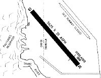
| Runways: | 03/21 |
| Longest Runway: | 03/21 is 4900 ft (1494 m) long |
| Runways with an Instrument Approach: |
U01 Airport Runway Details
| Runway 03/21 | 4900 ft x 50 ft (1494 m x 15 m) | |
| Runway Length Source: | NACO as of 06/18/1992 | |
| Surface: | Asphalt - Good condition - No special surface treatment | |
| Runway Edge Lights: | Medium Intensity | |
Runway 03 |
Runway 21 |
|
Elevation: |
4412.7 | 4413.2 |
Latitude: |
42-47-35.3060N | 42-48-05.3720N |
Longitude: |
112-49-56.4160W | 112-49-04.9280W |
|
Runway True Alignment: |
052 | 232 |
Glide Path Angle: |
0.0 degrees | 3.5 degrees |
Traffic Pattern: |
Left | Left |
Runway Markings Type: |
Basic | Basic |
Runway Markings Condition: |
Fair | Fair |
Object at End: |
FENCE | HILL |
Object Height: |
4 | 24 |
Distance from End: |
200 | 700 |
Object Centerline Offset: |
30 ft. right of centerline | 0 ft. left and right of centerline |
Visual Glide Slope Indicators: |
Tri-color VASI On Left Side Of Runway | |
Threshold Crossing Height: |
50 |
Services
Airframe Repair: |
Major |
Powerplant Repair: |
Major |
Bottled Oxygen: |
None |
Bulk Oxygen: |
None |
Fuel Available: |
100LL, MOGAS |
Landing Fees: |
No |
Parking: |
Tiedowns available |
Maps & Diagrams
U01 Sectional
Flight Planning
at skyvector.com
at skyvector.com