Location
Latitude: |
59-26-38.0600N (59.443906) |
Longitude: |
151-42-18.1500W (-151.705042) |
Elevation: |
29.0 feet MSL (9 m MSL) |
Magnetic Variation: |
14 E (as of April 2024 from WMM2020 model) |
Time Zone: |
UTC -9.0 (Standard Time) UTC -8.0 (Daylight Savings Time) |
From City: |
01 N.M. E of Seldovia, Alaska |
Found On: |
Kodiak Chart |
FAA Region: |
AAL |
Contacts
Manager: |
Publicly owned: |
| TYLER TUCKER/KEVIN JONES PO BOX 261 SELDOVIA, AK 99663-0261 907-234-7818 |
ALASKA DOT&PF CENTRAL REGION BOX 196900 ANCHORAGE, AK 99519-6900 907-269-0783 |
Operations
Airport Status: |
Operational |
Facility Use: |
Public |
Type: |
Airport |
Activation Date: |
08/1947 |
Control tower: |
No |
Attendance (Months/Days/Hours): |
Months/Days/Hours APR 16-OCT 14/MON-THURS/0600-1630 |
Boundary ARTCC: |
ZAN (Anchorage) |
Responsible ARTCC: |
ZAN (Anchorage) |
Segmented Circle Indicator: |
Yes |
Traffic Pattern Altitude (MSL): |
1029 feet (314 m) |
NOTAMs Facility: |
SOV |
NOTAM-D Service: |
Yes |
International Airport of Entry: |
No |
Customs Landing Rights: |
No |
Military Landing Rights: |
Yes |
Civil/Military Joint Use: |
No |
Based Aircraft
| Single Engine: | 2 |
Annual Operations (as of 12/31/2019)
| Total Operations: | 5660 | |
| Air Taxi: | 2160 | 38.2% |
| GA Local: | 1500 | 26.5% |
| GA Itinerant: | 2000 | 35.3% |
Communications
| CTAF: | 122.900 |
| ASOS: | 135.4 (907-234-7407) |
Fixed Based Operators (FBOs) & Fuel
(Click on a business for detail)
Please help us keep this information up to date. This is a FREE SERVICE just like everything else on Airport Guide! If you see that a business needs to be added, modified, or deleted please fill out our Update Form.
To add, modify, or delete a business click here.
Please help us keep this information up to date. This is a FREE SERVICE just like everything else on Airport Guide! If you see that a business needs to be added, modified, or deleted please fill out our Update Form.
Area Code: 907 |
| Business Name | Frequency | Phone | Fuel Grade |
|---|
Flight Service Stations
| Primary | Alternate | |
| FSS on Field: | N | |
| FSS Name (ID): | Homer(HOM) | Kenai (ENA) |
| Frequency: | ||
| Toll Free Phone: | LC235-8588 | 1-866-864-1737 |
Instrument Procedures / Charts
Terminal Procedures are only available for airports in several countries with more being added all the time. If you are looking for a specific country's charts, please send an email to support(at)airportguide.com stating the country name. This will be used to prioritize the implementation.
Navigation Aids (Navaids) near SOV
| Dist (NM) | ID | Morse Code | Name | Type | Freq | True Hdg | Mag Hdg |
|---|---|---|---|---|---|---|---|
| 13.4 | ACE | . _ _ . _ . . | Kachemak | NDB | 277 | 27 | 13 |
| 17.6 | HOM | . . . . _ _ _ _ _ | Homer | VOR-DME | 114.60 | 25 | 11 |
| 66.7 | OLT | _ _ _ . _ . . _ | Soldotna | NDB-DME | 346 | 21 | 7 |
| 70.9 | IWW | . . . _ _ . _ _ | Wildwood | NDB | 379 | 11 | 357 |
| 71.9 | ENA | . _ . . _ | Kenai | VOR-DME | 117.60 | 12 | 358 |
| 99.0 | ILI | . . . _ . . . . | Iliamna | NDB-DME | 411 | 282 | 269 |
Nearby Airports with Fuel
| Dist (NM) | Name (Airport IDs) | True Hdg | Mag Hdg | Fuel Grade |
|---|---|---|---|---|
| 13.1 | Homer-Beluga Lake Seaplane Base (5BL) |
25 | 11 | 100LL |
| 13.8 | Homer Airport (HOM PAHO HOM) |
28 | 14 | 100LL, Jet A |
| 65.0 | Soldotna Airport (SXQ PASX SXQ) |
17 | 3 | 100LL, Jet A |
| 69.2 | Kenai Municipal Airport (ENA PAEN ENA) |
11 | 357 | 100LL, Jet A |
| 99.3 | Iliamna Airport (ILI PAIL ILI) |
282 | 269 | 100LL, Jet A |
Notices to Airmen (NOTAMS)
Remarks
| A110-1 | TURBC WHEN WIND SE OR SW. |
| A110-10 | SNOW AND ICE REMOVAL AND ARPT CONDITIONS REPORTING PERFORMED DURING ATTENDANCE HRS ONLY. |
| A110-2 | WIND SHEAR ON APCH TO RWY 16. |
| A110-4 | COND NOT MONITORED; RECOMMEND VISUAL INSPECTION PRIOR TO LNDG. |
| A110-5 | 230 FT SAFETY AREA FOR RWY 34; 500 FT FOR RWY 16. |
| A110-6 | PILOTS REQUESTED TO SELF ANNOUNCE ON CTAF 5 NM FROM ARPT AND WHEN TAKING OFF AND CLEARING RWY. |
| A110-7 | NGT OPR NOT AUTHORIZED. |
| A13 | ALTERNATE PHONE: 907-235-5127 |
| A42-16 | RWY 16 & 34 NSTD MKGS; RWYS MKD WITH CONES. |
Runways
Runway Summary
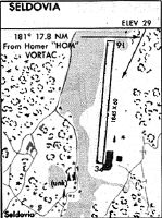
| Runways: | 16/34 |
| Longest Runway: | 16/34 is 1845 ft (562 m) long |
| Runways with an Instrument Approach: |
SOV Airport Runway Details
| Runway 16/34 | 1845 ft x 80 ft (562 m x 24 m) | |
| Runway Length Source: | STATE as of 01/14/2014 | |
| Surface: | Gravel - Good condition - No special surface treatment | |
Runway 16 |
Runway 34 |
|
Latitude: |
59-26-47.1200N | 59-26-28.9900N |
Longitude: |
151-42-16.8700W | 151-42-19.4200W |
Glide Path Angle: |
0.0 degrees | 0.0 degrees |
Traffic Pattern: |
Right | |
Runway Markings Type: |
Nonstandard (other than numbers only) | Nonstandard (other than numbers only) |
Object at End: |
HILL | HILL |
Object Height: |
220 | 213 |
Distance from End: |
3300 | 3885 |
Object Centerline Offset: |
0 ft. left and right of centerline | 100 ft. right of centerline |
Services
Fuel Available: |
100LL, Jet A |
Parking: |
Tiedowns available |
Maps & Diagrams
SOV Sectional
Flight Planning
at skyvector.com
at skyvector.com