Location
Latitude: |
35-14-14.7210N (35.237423) |
Longitude: |
079-23-20.5210W (-79.389034) |
Elevation: |
459.3 feet MSL (140 m MSL) |
Magnetic Variation: |
8.9 W (as of April 2024 from WMM2020 model) |
Time Zone: |
UTC -5.0 (Standard Time) UTC -4.0 (Daylight Savings Time) |
From City: |
03 N.M. N of Pinehurst/Southern Pines, North Carolina |
Found On: |
Charlotte Chart |
FAA Region: |
ASO |
Contacts
Manager: |
Publicly owned: |
| RON MANESS P.O. DRAWER 5809 PINEHURST, NC 28374 910-692-3212 |
COUNTY OF MOORE P O BOX 905 CARTHAGE, NC 28327 910-692-3212 |
Operations
Airport Status: |
Operational |
Facility Use: |
Public |
Type: |
Airport |
Activation Date: |
09/1937 |
Control tower: |
No |
Attendance (Months/Days/Hours): |
Months/Days/Hours ALL/ALL/0800-2000 |
Boundary ARTCC: |
ZDC (Washington) |
Responsible ARTCC: |
ZDC (Washington) |
Lighting Schedule: |
SEE RMK |
Segmented Circle Indicator: |
No |
Traffic Pattern Altitude (MSL): |
1459 feet (445 m) |
NOTAMs Facility: |
SOP |
NOTAM-D Service: |
Yes |
International Airport of Entry: |
No |
Customs Landing Rights: |
No |
Military Landing Rights: |
Yes |
Civil/Military Joint Use: |
No |
Based Aircraft
| Single Engine: | 79 |
| Multi Engine: | 9 |
| Jet Engine: | 2 |
Annual Operations (as of 07/13/2023)
| Total Operations: | 17454 | |
| Air Taxi: | 2384 | 13.7% |
| GA Local: | 10976 | 62.9% |
| GA Itinerant: | 3958 | 22.7% |
| Military Aircraft: | 136 | 0.8% |
Communications
| CTAF: | 123.050 |
| Unicom: | 123.050 |
| Clearance Del.: | 127.0 127.0 127.0 |
| Approach: | FAYETTEVILLE |
| Departure: | FAYETTEVILLE |
| AWOS-3PT: | 127.575 (910-692-4287) |
Fixed Based Operators (FBOs) & Fuel
(Click on a business for detail)
Please help us keep this information up to date. This is a FREE SERVICE just like everything else on Airport Guide! If you see that a business needs to be added, modified, or deleted please fill out our Update Form.
To add, modify, or delete a business click here.
Please help us keep this information up to date. This is a FREE SERVICE just like everything else on Airport Guide! If you see that a business needs to be added, modified, or deleted please fill out our Update Form.
Area Code: 910 |
| Business Name | Frequency | Phone | Fuel Grade |
|---|---|---|---|
| Moore County Airport
Update FBO info |
Unicom 123.05 | 692-3212 | 100LL, Jet A |
| Southeast Air Charter
Update FBO info |
695-2359 |
Flight Service Stations
| Primary | Alternate | |
| FSS on Field: | N | |
| FSS Name (ID): | Raleigh(RDU) | |
| Frequency: | ||
| Toll Free Phone: | 1-800-WX-BRIEF |
Instrument Procedures / Charts
FAA Terminal Procedures valid from 0901Z 03/21/24 to 0901Z 04/18/24.
There are various types of charts available for an airport. They are listed in the Page Type column. Here is a legend for those types:
APD - Airport Diagram
DP - Departure Procedure Charts
HOT - Hot Spots
IAP - Instrument Approach Procedure Charts
MIN - Minimums
STAR - Standard Terminal Arrival Charts
| Page Type | Page Name | Volume | Action Since Last Cycle |
|---|---|---|---|
| IAP | ILS Y OR LOC Y RWY 05 | SE-2 | |
| IAP | ILS Z OR LOC Z RWY 05 | SE-2 | |
| IAP | RNAV (GPS) RWY 05 | SE-2 | |
| IAP | RNAV (GPS) RWY 23 | SE-2 | |
| MIN | ALTERNATE MINIMUMS | SE-2 | |
| MIN | TAKEOFF MINIMUMS | SE-2 |
Terminal Procedures are only available for airports in several countries with more being added all the time. If you are looking for a specific country's charts, please send an email to support(at)airportguide.com stating the country name. This will be used to prioritize the implementation.
Navigation Aids (Navaids) near SOP
| Dist (NM) | ID | Morse Code | Name | Type | Freq | True Hdg | Mag Hdg |
|---|---|---|---|---|---|---|---|
| 9.8 | SDZ | . . . _ . . _ _ . . | Sandhills | VORTAC | 111.80 | 262 | 271 |
| 11.5 | EEJ | . . . _ _ _ | Lee County/Dcmsnd | NDB | 428 | 44 | 53 |
| 13.4 | HFF | . . . . . . _ . . . _ . | Mackall | NDB | 278 | 200 | 209 |
| 18.6 | POB | . _ _ . _ _ _ _ . . . | Pope | TACAN | 113.80 | 102 | 111 |
| 19.8 | TT | _ _ | Leeco | NDB | 406 | 37 | 46 |
| 21.3 | POB | . _ _ . _ _ _ _ . . . | Pope | NDB | 338 | 91 | 100 |
| 28.9 | FGP | . . _ . _ _ . . _ _ . | Fort Bragg | NDB | 393 | 101 | 110 |
| 29.4 | FAY | . . _ . . _ _ . _ _ | Fayetteville | VOR-DME | 114.85 | 120 | 129 |
| 30.4 | ME | _ _ . | Maxtn | NDB | 257 | 185 | 194 |
| 36.1 | LIB | . _ . . . . _ . . . | Liberty | VORTAC | 113.00 | 342 | 351 |
| 36.9 | HQT | . . . . _ _ . _ _ | Harnett | NDB | 417 | 71 | 80 |
| 37.2 | VU | . . . _ . . _ | Aller | NDB | 346 | 294 | 303 |
| 37.9 | CQW | _ . _ . _ _ . _ . _ _ | Cheraw | NDB | 409 | 218 | 227 |
| 40.7 | RSY | . _ . . . . _ . _ _ | Robeson | NDB | 359 | 156 | 165 |
| 40.7 | BES | _ . . . . . . . | Bennettsville | NDB | 230 | 204 | 213 |
| 41.0 | LBT | . _ . . _ . . . _ | Lumberton | VOR | 110.00 | 156 | 165 |
| 43.3 | JB | . _ _ _ _ . . . | Jigel | NDB | 384 | 163 | 172 |
| 45.5 | HB | . . . . _ . . . | Alamm | NDB | 361 | 347 | 356 |
| 47.2 | DLC | _ . . . _ . . _ . _ . | Dillon | NDB | 274 | 178 | 187 |
| 48.2 | RDU | . _ . _ . . . . _ | Raleigh/Durham | VORTAC | 117.20 | 37 | 46 |
Nearby Airports with Fuel
Notices to Airmen (NOTAMS)
Remarks
| A110-1 | NOISE ABATEMENT PROCEDURES IN EFFECT. CTC AMGR 910-692-3212. |
| A110-4 | BIRD ACTVTY ON & INVOF ARPT APR-OCT. |
| A110-5 | 12 HR PPR FOR JET OPNS CONDUCTED 2300-0600, CTC AMGR 910-692-3212. |
| A110-6 | MAINT AVBL. |
| A110-7 | FLT TRNG AVBL. |
| A110-8 | FOR CD CTC FAYETTEVILLE APCH 910-484-8012. |
| A110-9 | FIXED WING AIRCRAFT OPERATIONS NOT AUTHORIZED FROM ANY GRASS/TURF SURFACE. |
| A26 | CLSD TO UNSKED AIR CARRIER OPER WITH MORE THAN 30 PASSENGER SEATS; CALL AMGR 910-692-3212. |
| A57-05 | APCH RATIO 30:1 AT DSPLCD THR 72 FT TREES. |
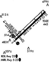
| A81-APT | ACTVT MALSR RWY 05; REIL RWY 23; HIRL RWY 05/23; TWY LGTS - CTAF. PAPI RWY 05 & 23 OPERS CONSLY. |
Runways
Runway Summary
| Runways: | 05/23 |
| Longest Runway: | 05/23 is 6503 ft (1982 m) long |
| Runways with an Instrument Approach: | 05 |
SOP Airport Runway Details
| Runway 05/23 | 6503 ft x 150 ft (1982 m x 46 m) | |
| Runway Length Source: | 3RD PARTY SURVEY as of 01/10/2019 | |
| Surface: | Asphalt - Excellent condition - Saw-cut or plastic grooved | |
| Runway Pavement Class: | 27 /F/A/X/T | |
| Runway Edge Lights: | High Intensity | |
Runway Weight Bearing Capacity (in thousands of pounds) |
||
| Single Wheel Landing Gear: | 100.0 | |
| Dual Wheel Landing Gear: | 162.0 | |
Runway 05 |
Runway 23 |
|
Elevation: |
459.3 | 433.2 |
Latitude: |
35-13-52.4768N | 35-14-36.9635N |
Longitude: |
079-23-48.8228W | 079-22-52.2146W |
|
Runway True Alignment: |
046 | 226 |
ILS Type: |
ILS/DME | |
Glide Path Angle: |
3.0 degrees | 3.0 degrees |
Traffic Pattern: |
Left | Left |
Runway Markings Type: |
Precision Instrument | Precision Instrument |
Runway Markings Condition: |
Good | Good |
Object at End: |
TREES | TREES |
Object Height: |
71 | 38 |
Distance from End: |
1740 | 987 |
Object Centerline Offset: |
456 ft. right of centerline | 185 ft. left of centerline |
Visual Glide Slope Indicators: |
4-Light PAPI On Left Side Of Runway | 4-Light PAPI On Right Side Of Runway |
Approach Light System: |
1,400 Foot Medium Intensity Approach Lighting System With Runway Alignment Indicator Lights | |
REIL: |
Yes | |
Threshold Crossing Height: |
40 | 41 |
Threshold Elevation: |
455.2 | 431.0 |
Displaced Threshold: |
600 | 400 |
Threshold Latitude: |
35-13-56.5806N | 35-14-34.2307N |
Threshold Longitude: |
079-23-43.5994W | 079-22-55.6981W |
Declared Distances |
||
Take Off Run Avbl. (TORA): |
6502 | 6502 |
Take Off Distance Avbl. (TODA): |
6502 | 6502 |
Actual Stop Dist. Avbl. (ASDA): |
6102 | 6102 |
Landing Dist. Avbl. (LDA): |
5502 | 5722 |
Services
Airframe Repair: |
Major |
Powerplant Repair: |
Major |
Bottled Oxygen: |
None |
Bulk Oxygen: |
None |
Fuel Available: |
100LL, Jet A-1+ |
Landing Fees: |
No |
Parking: |
Tiedowns available |
Maps & Diagrams
SOP Sectional
Flight Planning
at skyvector.com
at skyvector.com