Location
Latitude: |
32-26-47.4550N (32.446515) |
Longitude: |
093-49-33.7440W (-93.82604) |
Elevation: |
257.6 feet MSL (79 m MSL) |
Magnetic Variation: |
0.9 E (as of April 2024 from WMM2020 model) |
Time Zone: |
UTC -6.0 (Standard Time) UTC -5.0 (Daylight Savings Time) |
From City: |
04 N.M. SW of Shreveport, Louisiana |
Found On: |
Memphis Chart |
FAA Region: |
ASW |
Contacts
Manager: |
Publicly owned: |
| LARRY BLACKWELL 5103 HOLLYWOOD AVE SUITE 300 SHREVEPORT, LA 71109 318-673-5370 |
CITY OF SHREVEPORT 505 TRAVIS STREET SHREVEPORT, LA 71101 318-673-5050 |
Operations
Airport Status: |
Operational |
Facility Use: |
Public |
Type: |
Airport |
Activation Date: |
08/1952 |
Control tower: |
Yes |
Attendance (Months/Days/Hours): |
Months/Days/Hours ALL/ALL/ALL |
Boundary ARTCC: |
ZFW (Fort Worth) |
Responsible ARTCC: |
ZFW (Fort Worth) |
Lighting Schedule: |
SS-SR |
Segmented Circle Indicator: |
No |
Traffic Pattern Altitude (MSL): |
1258 feet (383 m) |
NOTAMs Facility: |
SHV |
NOTAM-D Service: |
Yes |
International Airport of Entry: |
No |
Customs Landing Rights: |
Yes |
Military Landing Rights: |
Yes |
Civil/Military Joint Use: |
No |
Aircraft Rescue and Firefighting: |
Class I ARFF Index: B Air Carrier Service: Scheduled Certification Date: 05/1973 |
Based Aircraft
| Single Engine: | 15 |
| Multi Engine: | 13 |
| Jet Engine: | 18 |
| GA Helicopters: | 2 |
Annual Operations (as of 12/31/2022)
| Total Operations: | 32496 | |
| Commercial: | 8264 | 25.4% |
| Air Taxi: | 9915 | 30.5% |
| GA Local: | 1141 | 3.5% |
| GA Itinerant: | 10191 | 31.4% |
| Military Aircraft: | 2985 | 9.2% |
Communications
| Unicom: | 122.950 |
| Tower: | SHREVEPORT 121.4 236.775 Hrs: 24 |
| Clearance Del.: | 124.65 |
| Ground: | 121.175 236.775 |
| Approach: | SHREVEPORT 119.9 119.9 |
| Departure: | SHREVEPORT 119.9 119.9 |
| ATIS: | 128.45 Hrs: 24 |
| ASOS: | 128.45 (318-636-5767) |
| EMERG: | 121.5 |
| EMERG: | 243.0 |
Fixed Based Operators (FBOs) & Fuel
(Click on a business for detail)
Please help us keep this information up to date. This is a FREE SERVICE just like everything else on Airport Guide! If you see that a business needs to be added, modified, or deleted please fill out our Update Form.
To add, modify, or delete a business click here.
Please help us keep this information up to date. This is a FREE SERVICE just like everything else on Airport Guide! If you see that a business needs to be added, modified, or deleted please fill out our Update Form.
Area Code: 318 |
| Business Name | Frequency | Phone | Fuel Grade |
|---|---|---|---|
| TAC Air
Update FBO info |
Unicom 122.95 | 636-1000 | 100LL, Jet A |
Flight Service Stations
| Primary | Alternate | |
| FSS on Field: | N | |
| FSS Name (ID): | De Ridder(DRI) | |
| Frequency: | ||
| Toll Free Phone: | 1-800-WX-BRIEF |
Instrument Procedures / Charts
FAA Terminal Procedures valid from 0901Z 03/21/24 to 0901Z 04/18/24.
There are various types of charts available for an airport. They are listed in the Page Type column. Here is a legend for those types:
APD - Airport Diagram
DP - Departure Procedure Charts
HOT - Hot Spots
IAP - Instrument Approach Procedure Charts
MIN - Minimums
STAR - Standard Terminal Arrival Charts
| Page Type | Page Name | Volume | Action Since Last Cycle |
|---|---|---|---|
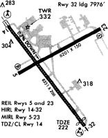
| APD | AIRPORT DIAGRAM | SC-4 | |
| IAP | ILS OR LOC RWY 14 | SC-4 | Changed |
| IAP | ILS OR LOC RWY 32 | SC-4 | Changed |
| IAP | ILS RWY 14 (CAT II) | SC-4 | Changed |
| IAP | LOC RWY 06 | SC-4 | Changed |
| IAP | RNAV (GPS) RWY 06 | SC-4 | Changed |
| IAP | RNAV (GPS) RWY 14 | SC-4 | Changed |
| IAP | RNAV (GPS) RWY 24 | SC-4 | Changed |
| IAP | RNAV (GPS) RWY 32 | SC-4 | Changed |
| MIN | ALTERNATE MINIMUMS | SC-4 | |
| MIN | RADAR MINIMUMS | SC-4 | |
| MIN | TAKEOFF MINIMUMS | SC-4 |
Terminal Procedures are only available for airports in several countries with more being added all the time. If you are looking for a specific country's charts, please send an email to support(at)airportguide.com stating the country name. This will be used to prioritize the implementation.
Navigation Aids (Navaids) near SHV
| Dist (NM) | ID | Morse Code | Name | Type | Freq | True Hdg | Mag Hdg |
|---|---|---|---|---|---|---|---|
| 0.5 | SHV | . . . . . . . . . . _ | Shreveport | VOT | 108.20 | 276 | 275 |
| 7.1 | DTN | _ . . _ _ . | Downtown | VOR | 108.60 | 37 | 36 |
| 8.7 | BAD | _ . . . . _ _ . . | Barksdale | TACAN | 115.80 | 66 | 65 |
| 12.0 | EMG | . _ _ _ _ . | Elm Grove | VORTAC | 111.20 | 103 | 102 |
| 19.5 | EIC | . . . _ . _ . | Belcher | VORTAC | 117.40 | 2 | 1 |
| 23.1 | MSD | _ _ . . . _ . . | Mansfield | NDB | 414 | 172 | 171 |
| 26.5 | VIV | . . . _ . . . . . _ | Vivian | NDB | 284 | 339 | 338 |
| 28.7 | RPF | . _ . . _ _ . . . _ . | Carthage | NDB | 332 | 236 | 235 |
| 40.4 | CZJ | _ . _ . _ _ . . . _ _ _ | Amason | NDB | 341 | 204 | 203 |
| 43.5 | ATA | . _ _ . _ | Atlanta | NDB | 347 | 335 | 334 |
| 47.0 | GGG | _ _ . _ _ . _ _ . | Gregg County | VORTAC | 112.90 | 268 | 267 |
| 49.2 | GG | _ _ . _ _ . | Veels | NDB | 410 | 270 | 269 |
| 54.5 | MMY | _ _ _ _ _ . _ _ | Many | NDB | 272 | 164 | 163 |
| 54.7 | HNO | . . . . _ . _ _ _ | Henderson | NDB | 371 | 253 | 252 |
| 57.7 | JBL | . _ _ _ _ . . . . _ . . | Hodge | NDB | 256 | 104 | 103 |
| 60.7 | OOC | _ _ _ _ _ _ _ . _ . | Natchitoches | NDB | 407 | 141 | 140 |
| 62.7 | TUF | _ . . _ . . _ . | Stuckey | NDB | 350 | 91 | 91 |
| 63.4 | ROQ | . _ . _ _ _ _ _ . _ | Ruston | NDB | 368 | 80 | 80 |
| 64.8 | TX | _ _ . . _ | Tecco | NDB | 234 | 356 | 355 |
| 64.9 | SWB | . . . . _ _ _ . . . | Sawmill | VOR-DME | 113.75 | 115 | 115 |
Nearby Airports with Fuel
Notices to Airmen (NOTAMS)
Remarks
| A110-1 | FLIGHT NOTIFICATION SERVICE (ADCUS) AVBL MON-FRI 0800-1700; OTHER TIMES BY APPOINTMENT CALL 318-635-7873 OR 800-973-2867. |
| A110-4 | BIRD ACTIVITY INVOF ARPT. |
| A24 | LNDG FEE FOR ALL COMMERCIAL TFC. |
| A57-32 | APCH RATIO 40:1 FM DSPLCD THR. |
Runways
Runway Summary
| Runways: | 06/24 14/32 |
| Longest Runway: | 14/32 is 8348 ft (2544 m) long |
| Runways with an Instrument Approach: | 06, 14, 32 |
SHV Airport Runway Details
| Runway 06/24 | 7003 ft x 150 ft (2135 m x 46 m) | |
| Runway Length Source: | 3RD PARTY SURVEY as of 10/08/2020 | |
| Surface: | Asphalt - Excellent condition - Saw-cut or plastic grooved | |
| Runway Pavement Class: | 49 /F/C/Y/T | |
| Runway Edge Lights: | Medium Intensity | |
Runway Weight Bearing Capacity (in thousands of pounds) |
||
| Single Wheel Landing Gear: | 75.0 | |
| Dual Wheel Landing Gear: | 158.0 | |
| Dual Tandem Wheel Landing Gear: | 280.0 | |
Runway 06 |
Runway 24 |
|
Elevation: |
238.3 | 228.4 |
Latitude: |
32-26-38.3348N | 32-27-12.0324N |
Longitude: |
093-50-06.6750W | 093-48-55.2722W |
|
Runway True Alignment: |
061 | 241 |
ILS Type: |
LOC/DME | |
Glide Path Angle: |
3.0 degrees | 3.0 degrees |
Traffic Pattern: |
Left | Left |
Runway Markings Type: |
Nonprecision Instrument | Nonprecision Instrument |
Runway Markings Condition: |
Good | Good |
Object at End: |
TREES | TREES |
Object Height: |
77 | 111 |
Distance from End: |
2000 | 3800 |
Object Centerline Offset: |
300 ft. right of centerline | 0 ft. left and right of centerline |
Visual Glide Slope Indicators: |
4-Light PAPI On Left Side Of Runway | 4-Light PAPI On Right Side Of Runway |
REIL: |
Yes | Yes |
Threshold Crossing Height: |
50 | 50 |
Declared Distances |
||
Take Off Run Avbl. (TORA): |
7003 | 7003 |
Take Off Distance Avbl. (TODA): |
7003 | 7003 |
Actual Stop Dist. Avbl. (ASDA): |
7003 | 7003 |
Landing Dist. Avbl. (LDA): |
7003 | 7003 |
| Runway 14/32 | 8348 ft x 200 ft (2544 m x 61 m) | |
| Runway Length Source: | 3RD PARTY SURVEY as of 06/17/2017 | |
| Surface: | Asphalt - Excellent condition - Saw-cut or plastic grooved | |
| Runway Pavement Class: | 46 /F/A/Y/T | |
| Runway Edge Lights: | High Intensity | |
Runway Weight Bearing Capacity (in thousands of pounds) |
||
| Single Wheel Landing Gear: | 75.0 | |
| Dual Wheel Landing Gear: | 190.0 | |
| Dual Tandem Wheel Landing Gear: | 400.0 | |
Runway 14 |
Runway 32 |
|
Elevation: |
257.6 | 222.1 |
Latitude: |
32-27-13.8290N | 32-26-08.1115N |
Longitude: |
093-50-05.5773W | 093-49-06.5623W |
|
Runway True Alignment: |
143 | 323 |
ILS Type: |
ILS/DME | ILS |
Glide Path Angle: |
3.0 degrees | 0.0 degrees |
Traffic Pattern: |
Left | Left |
Runway Markings Type: |
Precision Instrument | Precision Instrument |
Runway Markings Condition: |
Good | Good |
Object at End: |
RR | |
Object Height: |
32 | |
Distance from End: |
920 | |
Object Centerline Offset: |
300 ft. right of centerline | 0 ft. left and right of centerline |
Visual Glide Slope Indicators: |
4-Light PAPI On Right Side Of Runway | |
Runway Visual Range (RVR): |
Touchdown, Midfield, Rollout | Touchdown, Midfield, Rollout |
Approach Light System: |
Standard 2,400 Foot High Intensity Approach Lighting System With Sequenced Flashers, Cat. II or III Config. | 1,400 Foot Medium Intensity Approach Lighting System With Runway Alignment Indicator Lights |
Touchdown Lights: |
Yes | No |
Centerline Lights: |
Yes | Yes |
Threshold Crossing Height: |
50 | |
Threshold Elevation: |
220.1 | |
Displaced Threshold: |
373 | |
Threshold Latitude: |
32-26-11.0480N | |
Threshold Longitude: |
093-49-09.1990W | |
Declared Distances |
||
Take Off Run Avbl. (TORA): |
8348 | 8348 |
Take Off Distance Avbl. (TODA): |
8348 | 8348 |
Actual Stop Dist. Avbl. (ASDA): |
8118 | 8348 |
Landing Dist. Avbl. (LDA): |
8118 | 7975 |
Services
Airframe Repair: |
Major |
Powerplant Repair: |
Major |
Fuel Available: |
100LL, Jet A |
Parking: |
Hangars and tiedowns available |
Maps & Diagrams
SHV Sectional
Flight Planning
at skyvector.com
at skyvector.com