Location
Latitude: |
45-49-21.6690N (45.822686) |
Longitude: |
115-26-23.4590W (-115.43985) |
Elevation: |
4097.0 feet MSL (1249 m MSL) |
Magnetic Variation: |
13.1 E (as of April 2024 from WMM2020 model) |
Time Zone: |
UTC -8.0 (Standard Time) UTC -7.0 (Daylight Savings Time) |
From City: |
00 N.M. SW of Elk City, Idaho |
Found On: |
Great Falls Chart |
FAA Region: |
ANM |
Contacts
Manager: |
Publicly owned: |
| DEBBIE TAYLOR PO BOX 345 ELK CITY, ID 83525 (208) 842-2494 |
ELK CITY AREA ALLIANCE GEN DELIVERY ELK CITY, ID 83525 208-842-2311 |
Operations
Airport Status: |
Operational |
Facility Use: |
Public |
Type: |
Airport |
Activation Date: |
05/1951 |
Control tower: |
No |
Attendance (Months/Days/Hours): |
Months/Days/Hours Unattended |
Boundary ARTCC: |
ZSE (Seattle) |
Responsible ARTCC: |
ZSE (Seattle) |
Segmented Circle Indicator: |
No |
Traffic Pattern Altitude (MSL): |
5097 feet (1554 m) |
NOTAMs Facility: |
BOI |
NOTAM-D Service: |
Yes |
Military Landing Rights: |
No |
Civil/Military Joint Use: |
No |
Based Aircraft
| Single Engine: | 1 |
Annual Operations (as of 07/30/2022)
| Total Operations: | 1250 | |
| Air Taxi: | 50 | 4.0% |
| GA Itinerant: | 1200 | 96.0% |
Communications
| CTAF: | 122.900 |
Fixed Based Operators (FBOs) & Fuel
(Click on a business for detail)
Please help us keep this information up to date. This is a FREE SERVICE just like everything else on Airport Guide! If you see that a business needs to be added, modified, or deleted please fill out our Update Form.
To add, modify, or delete a business click here.
Please help us keep this information up to date. This is a FREE SERVICE just like everything else on Airport Guide! If you see that a business needs to be added, modified, or deleted please fill out our Update Form.
Area Code: 208 |
| Business Name | Frequency | Phone | Fuel Grade |
|---|
Flight Service Stations
| Primary | Alternate | |
| FSS on Field: | N | |
| FSS Name (ID): | Boise(BOI) | |
| Frequency: | ||
| Toll Free Phone: | 1-800-WX-BRIEF |
Instrument Procedures / Charts
Terminal Procedures are only available for airports in several countries with more being added all the time. If you are looking for a specific country's charts, please send an email to support(at)airportguide.com stating the country name. This will be used to prioritize the implementation.
Navigation Aids (Navaids) near S90
| Dist (NM) | ID | Morse Code | Name | Type | Freq | True Hdg | Mag Hdg |
|---|---|---|---|---|---|---|---|
| 45.2 | IDQ | . . _ . . _ _ . _ | Cottonwood | DME | 115.65 | 289 | 276 |
| 68.3 | MQG | _ _ _ _ . _ _ _ . | Nez Perce | VOR-DME | 114.45 | 299 | 286 |
| 71.1 | DNJ | _ . . _ . . _ _ _ | Donnelly | VOR-DME | 116.20 | 207 | 194 |
| 74.6 | LKT | . _ . . _ . _ _ | Salmon | VOR-DME | 113.50 | 129 | 116 |
| 86.0 | MSO | _ _ . . . _ _ _ | Missoula | VOR-DME | 112.80 | 40 | 27 |
| 87.6 | INE | . . _ . . | Konna | NDB | 521 | 29 | 16 |
| 89.9 | PUW | . _ _ . . . _ . _ _ | Pullman | VOR-DME | 117.15 | 305 | 292 |
| 98.4 | MLP | _ _ . _ . . . _ _ . | Mullan Pass | VOR-DME | 117.80 | 355 | 342 |
Nearby Airports with Fuel
Notices to Airmen (NOTAMS)
Remarks
| A110-1 | LAND RY 14 TKOF RY 35 WHEN WIND CONDITIONS ALLOW. |
| A110-2 | RWY NOT MAINTAINED IN THE WINTER. |
| A110-4 | RWY 14 THR NOT DEFINED. |
| A110-5 | FOR CD CTC SEATTLE ARTCC AT 253-351-3694. |
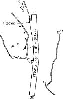
| A30-14/35 | IS A CURVED RWY. |
| A52-35 | ADDNL OBSTNS: +100' RIDGE AT 1200'; ON CNTRLN +35' RIDGE AT 500' ON CNTRLN; 250'TREES & TERRAIN AT 2500' ON CNTRLN. |
Runways
Runway Summary
| Runways: | 14/35 |
| Longest Runway: | 14/35 is 2600 ft (792 m) long |
| Runways with an Instrument Approach: |
S90 Airport Runway Details
| Runway 14/35 | 2600 ft x 150 ft (792 m x 46 m) | |
| Surface: | Turf - Fair condition - No special surface treatment | |
Runway 14 |
Runway 35 |
|
Glide Path Angle: |
0.0 degrees | 0.0 degrees |
Traffic Pattern: |
Left | Left |
Object at End: |
TREES | TREES |
Object Height: |
50 | 60 |
Distance from End: |
0 | 0 |
Object Centerline Offset: |
100 ft. left of centerline | 70 ft. left and right of centerline |
Services
Airframe Repair: |
None |
Powerplant Repair: |
None |
Bottled Oxygen: |
None |
Bulk Oxygen: |
None |
Fuel Available: |
100LL |
Landing Fees: |
No |
Parking: |
Tiedowns available |
Maps & Diagrams
S90 Sectional
Flight Planning
at skyvector.com
at skyvector.com