Location
Latitude: |
32-30-47.6090N (32.513225) |
Longitude: |
092-35-18.4010W (-92.588445) |
Elevation: |
316.8 feet MSL (97 m MSL) |
Magnetic Variation: |
0.1 E (as of April 2024 from WMM2020 model) |
Time Zone: |
UTC -6.0 (Standard Time) UTC -5.0 (Daylight Savings Time) |
From City: |
03 N.M. E of Ruston, Louisiana |
Found On: |
Memphis Chart |
FAA Region: |
ASW |
Contacts
Manager: |
Publicly owned: |
| JOHN FREEMAN 701 E. TENNESSEE AVE, PO BOX 2069 RUSTON, LA 71270 318-242-7703 |
CITY OF RUSTON 401 N. TRENTON RUSTON, LA 71270 318-251-8620 |
Operations
Airport Status: |
Operational |
Facility Use: |
Public |
Type: |
Airport |
Activation Date: |
01/1994 |
Control tower: |
No |
Attendance (Months/Days/Hours): |
Months/Days/Hours ALL/ALL/0700-1900 |
Boundary ARTCC: |
ZFW (Fort Worth) |
Responsible ARTCC: |
ZFW (Fort Worth) |
Lighting Schedule: |
SEE RMK |
Segmented Circle Indicator: |
Yes |
Traffic Pattern Altitude (MSL): |
1317 feet (401 m) |
NOTAMs Facility: |
RSN |
NOTAM-D Service: |
Yes |
Based Aircraft
| Single Engine: | 26 |
| Multi Engine: | 2 |
| Jet Engine: | 3 |
| GA Helicopters: | 1 |
Annual Operations (as of 11/14/2023)
| Total Operations: | 86300 | |
| GA Local: | 80000 | 92.7% |
| GA Itinerant: | 6200 | 7.2% |
| Military Aircraft: | 100 | 0.1% |
Communications
| CTAF: | 122.700 |
| Unicom: | 122.700 |
| Clearance Del.: | 118.8 118.8 118.8 |
| Approach: | MONROE FORT WORTH ARTCC |
| Departure: | MONROE FORT WORTH ARTCC |
| AWOS-3PT: | 119.525 (318-242-0062) |
- APCH/DEP CTL SVC PRVDD BY FORT WORTH ARTCC (ZFW) ON FREQS 126.325/346.25 (MONROE RCAG) WHEN MONROE APCH CTL (MLU) CLSD.
Fixed Based Operators (FBOs) & Fuel
(Click on a business for detail)
Please help us keep this information up to date. This is a FREE SERVICE just like everything else on Airport Guide! If you see that a business needs to be added, modified, or deleted please fill out our Update Form.
To add, modify, or delete a business click here.
Please help us keep this information up to date. This is a FREE SERVICE just like everything else on Airport Guide! If you see that a business needs to be added, modified, or deleted please fill out our Update Form.
Area Code: 318 |
| Business Name | Frequency | Phone | Fuel Grade |
|---|
Flight Service Stations
| Primary | Alternate | |
| FSS on Field: | N | |
| FSS Name (ID): | De Ridder(DRI) | |
| Frequency: | ||
| Toll Free Phone: | 1-800-WX-BRIEF |
Instrument Procedures / Charts
FAA Terminal Procedures valid from 0901Z 03/21/24 to 0901Z 04/18/24.
There are various types of charts available for an airport. They are listed in the Page Type column. Here is a legend for those types:
APD - Airport Diagram
DP - Departure Procedure Charts
HOT - Hot Spots
IAP - Instrument Approach Procedure Charts
MIN - Minimums
STAR - Standard Terminal Arrival Charts
| Page Type | Page Name | Volume | Action Since Last Cycle |
|---|---|---|---|
| IAP | RNAV (GPS) RWY 18 | SC-4 | |
| IAP | RNAV (GPS) RWY 36 | SC-4 | |
| IAP | VOR-A | SC-4 | |
| MIN | ALTERNATE MINIMUMS | SC-4 | |
| MIN | TAKEOFF MINIMUMS | SC-4 |
Terminal Procedures are only available for airports in several countries with more being added all the time. If you are looking for a specific country's charts, please send an email to support(at)airportguide.com stating the country name. This will be used to prioritize the implementation.
Navigation Aids (Navaids) near RSN
| Dist (NM) | ID | Morse Code | Name | Type | Freq | True Hdg | Mag Hdg |
|---|---|---|---|---|---|---|---|
| 5.7 | ROQ | . _ . _ _ _ _ _ . _ | Ruston | NDB | 368 | 359 | 359 |
| 6.3 | TUF | _ . . _ . . _ . | Stuckey | NDB | 350 | 180 | 180 |
| 19.8 | JBL | . _ _ _ _ . . . . _ . . | Hodge | NDB | 256 | 200 | 200 |
| 24.8 | ML | _ _ . _ . . | Sabar | NDB | 392 | 98 | 98 |
| 28.0 | MLU | _ _ . _ . . . . _ | Monroe | VORTAC | 117.20 | 89 | 89 |
| 32.7 | SWB | . . . . _ _ _ . . . | Sawmill | VOR-DME | 113.75 | 187 | 187 |
| 38.5 | BQP | _ . . . _ _ . _ . _ _ . | Bastrop | NDB | 329 | 67 | 67 |
| 41.5 | MRK | _ _ . _ . _ . _ | Molly Ridge | NDB | 338 | 98 | 98 |
| 45.3 | ELD | . . _ . . _ . . | El Dorado | VOR-DME | 115.50 | 350 | 350 |
| 46.9 | EL | . . _ . . | Lados | NDB | 418 | 351 | 351 |
| 51.4 | EMG | . _ _ _ _ . | Elm Grove | VORTAC | 111.20 | 262 | 262 |
| 54.6 | BAD | _ . . . . _ _ . . | Barksdale | TACAN | 115.80 | 269 | 269 |
| 57.1 | OOC | _ _ _ _ _ _ _ . _ . | Natchitoches | NDB | 407 | 205 | 205 |
| 58.3 | DTN | _ . . _ _ . | Downtown | VOR | 108.60 | 271 | 271 |
| 63.3 | SHV | . . . . . . . . . . _ | Shreveport | VOT | 108.20 | 266 | 266 |
| 63.6 | EIC | . . . _ . _ . | Belcher | VORTAC | 117.40 | 284 | 284 |
| 65.5 | MSD | _ _ . . . _ . . | Mansfield | NDB | 414 | 246 | 246 |
| 73.1 | BLE | _ . . . . _ . . . | Lake Providence | NDB | 278 | 74 | 74 |
| 74.5 | MMY | _ _ _ _ _ . _ _ | Many | NDB | 272 | 220 | 220 |
| 74.7 | VIV | . . . _ . . . . . _ | Vivian | NDB | 284 | 286 | 285 |
Nearby Airports with Fuel
Notices to Airmen (NOTAMS)
Remarks
| A110-2 | NUMEROUS TRNG ACFT IN VICINITY. |
| A110-3 | MEN AND EQUIPMENT OPERATING NEAR THE RUNWAY MARCH-OCTOBER |
| A110-4 | FOR CD CTC MONROE APCH AT 318-327-5641 OR 118.8, IF UNAVBL, CTC FORT WORTH ARTCC AT 817-858-7584 |
| A14 | DIRECTOR OF PUBLIC WORKS |
| A43-18 | RWY 18 PAPI OTS |
| A70-FUEL-10 | 0LL FOR FUEL AFTER HOURS CALL IN ADVANCE DURING WORKING HOURS 318-251-9098. |
| A81-APT | REIL RWY 18 & 36; MIRL RWY 18/36 - PRESET LOW INTST DUSK-DAWN; TO INCR INTST ACTVT - CTAF. |
| E111 | PRVDD ALL CONDITIONS LISTED IN THE 2/10/94 LTR ARE ADHERED TO. |
Runways
Runway Summary
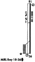
| Runways: | 18/36 |
| Longest Runway: | 18/36 is 6002 ft (1829 m) long |
| Runways with an Instrument Approach: |
RSN Airport Runway Details
| Runway 18/36 | 6002 ft x 100 ft (1829 m x 30 m) | |
| Runway Length Source: | 3RD PARTY SURVEY as of 03/18/2019 | |
| Surface: | Asphalt - Excellent condition - No special surface treatment | |
| Runway Pavement Class: | 30 /F/B/X/T | |
| Runway Edge Lights: | Medium Intensity | |
Runway Weight Bearing Capacity (in thousands of pounds) |
||
| Single Wheel Landing Gear: | 78.0 | |
| Dual Wheel Landing Gear: | 119.0 | |
Runway 18 |
Runway 36 |
|
Elevation: |
276.2 | 316.8 |
Latitude: |
32-31-17.3022N | 32-30-17.9158N |
Longitude: |
092-35-18.3609W | 092-35-18.4420W |
|
Runway True Alignment: |
180 | 000 |
Glide Path Angle: |
3.0 degrees | 3.0 degrees |
Runway Markings Type: |
Nonprecision Instrument | Nonprecision Instrument |
Runway Markings Condition: |
Fair | Fair |
Object at End: |
TREES | |
Object Height: |
60 | |
Distance from End: |
2383 | |
Object Centerline Offset: |
450 ft. left of centerline | |
Visual Glide Slope Indicators: |
4-Light PAPI On Left Side Of Runway | 4-Light PAPI On Left Side Of Runway |
REIL: |
Yes | Yes |
Threshold Crossing Height: |
50 | 55 |
Services
Airframe Repair: |
Minor |
Powerplant Repair: |
Minor |
Bottled Oxygen: |
None |
Bulk Oxygen: |
None |
Fuel Available: |
100LL, Jet A |
Landing Fees: |
No |
Parking: |
Hangars and tiedowns available |
Maps & Diagrams
RSN Sectional
Flight Planning
at skyvector.com
at skyvector.com