Location
Latitude: |
37-11-03.4850N (37.184301) |
Longitude: |
077-30-22.2280W (-77.506174) |
Elevation: |
192.7 feet MSL (59 m MSL) |
Magnetic Variation: |
10.2 W (as of April 2024 from WMM2020 model) |
Time Zone: |
UTC -5.0 (Standard Time) UTC -4.0 (Daylight Savings Time) |
From City: |
05 N.M. SW of Petersburg, Virginia |
Found On: |
Washington Chart |
FAA Region: |
AEA |
Contacts
Manager: |
Publicly owned: |
| JEREMY PULTZ 6775 BECK-CHAPPELL DRIVE PETERSBURG, VA 23803 804-861-0218 |
DINWIDDIE ARPT AND INDUSTRIAL AUTH. 6775 BECK-CHAPPELL DRIVE PETERSBURG, VA 23803 804-861-0218 |
Operations
Airport Status: |
Operational |
Facility Use: |
Public |
Type: |
Airport |
Activation Date: |
04/1976 |
Control tower: |
No |
Attendance (Months/Days/Hours): |
Months/Days/Hours OCT-MAR/MON-SUN/0700-1800 |
Boundary ARTCC: |
ZDC (Washington) |
Responsible ARTCC: |
ZDC (Washington) |
Lighting Schedule: |
SEE RMK |
Segmented Circle Indicator: |
No |
Traffic Pattern Altitude (MSL): |
1193 feet (364 m) |
NOTAMs Facility: |
PTB |
NOTAM-D Service: |
Yes |
International Airport of Entry: |
No |
Customs Landing Rights: |
No |
Military Landing Rights: |
Yes |
Civil/Military Joint Use: |
No |
Based Aircraft
| Single Engine: | 43 |
| Multi Engine: | 4 |
| Jet Engine: | 4 |
| GA Helicopters: | 1 |
Annual Operations (as of 12/31/2018)
| Total Operations: | 32623 | |
| Air Taxi: | 2572 | 7.9% |
| GA Local: | 5089 | 15.6% |
| GA Itinerant: | 14964 | 45.9% |
| Military Aircraft: | 9998 | 30.6% |
Communications
| CTAF: | 122.700 |
| Unicom: | 122.700 |
| Approach: | POTOMAC 126.75 126.75 |
| Departure: | POTOMAC 126.75 126.75 |
| AWOS-3: | 133.325 (804-861-5551) |
- APCH/DEP SVC PRVDD BY POTOMAC TRACON 126.75/307.2.
Fixed Based Operators (FBOs) & Fuel
(Click on a business for detail)
Please help us keep this information up to date. This is a FREE SERVICE just like everything else on Airport Guide! If you see that a business needs to be added, modified, or deleted please fill out our Update Form.
To add, modify, or delete a business click here.
Please help us keep this information up to date. This is a FREE SERVICE just like everything else on Airport Guide! If you see that a business needs to be added, modified, or deleted please fill out our Update Form.
Area Code: 804 |
| Business Name | Frequency | Phone | Fuel Grade |
|---|
Flight Service Stations
| Primary | Alternate | |
| FSS on Field: | N | |
| FSS Name (ID): | Leesburg(DCA) | |
| Frequency: | ||
| Toll Free Phone: | 1-800-WX-BRIEF |
Instrument Procedures / Charts
FAA Terminal Procedures valid from 0901Z 03/21/24 to 0901Z 04/18/24.
There are various types of charts available for an airport. They are listed in the Page Type column. Here is a legend for those types:
APD - Airport Diagram
DP - Departure Procedure Charts
HOT - Hot Spots
IAP - Instrument Approach Procedure Charts
MIN - Minimums
STAR - Standard Terminal Arrival Charts
| Page Type | Page Name | Volume | Action Since Last Cycle |
|---|---|---|---|
| IAP | LOC RWY 05 | NE-3 | |
| IAP | RNAV (GPS) RWY 05 | NE-3 | Changed |
| IAP | RNAV (GPS) RWY 23 | NE-3 | Changed |
| IAP | VOR RWY 23 | NE-3 | |
| MIN | ALTERNATE MINIMUMS | NE-3 | |
| MIN | TAKEOFF MINIMUMS | NE-3 |
Terminal Procedures are only available for airports in several countries with more being added all the time. If you are looking for a specific country's charts, please send an email to support(at)airportguide.com stating the country name. This will be used to prioritize the implementation.
Navigation Aids (Navaids) near PTB
| Dist (NM) | ID | Morse Code | Name | Type | Freq | True Hdg | Mag Hdg |
|---|---|---|---|---|---|---|---|
| 9.3 | CF | _ . _ . . . _ . | Pubbs | NDB | 392 | 15 | 25 |
| 20.6 | HPW | . . . . . _ _ . . _ _ | Hopewell | VORTAC | 112.00 | 64 | 74 |
| 21.0 | RIC | . _ . . . _ . _ . | Richmond | VORTAC | 114.10 | 24 | 34 |
| 25.7 | FAK | . . _ . . _ _ . _ | Flat Rock | VORTAC | 113.30 | 323 | 333 |
| 26.0 | BKT | _ . . . _ . _ _ | Blackstone | NDB | 326 | 262 | 272 |
| 27.0 | AKQ | . _ _ . _ _ _ . _ | Wakefield | NDB | 274 | 116 | 126 |
| 29.1 | LVL | . _ . . . . . _ . _ . . | Lawrenceville | VORTAC | 112.90 | 220 | 230 |
| 34.2 | ELQ | . . _ . . _ _ . _ | Emporia | NDB | 261 | 173 | 183 |
| 36.8 | FKN | . . _ . _ . _ _ . | Franklin | VORTAC | 110.60 | 139 | 149 |
| 39.6 | MBV | _ _ _ . . . . . . _ | Mecklenburg/Dcmsnd | NDB | 356 | 221 | 231 |
| 41.1 | HCM | . . . . _ . _ . _ _ | Harcum | VORTAC | 108.80 | 67 | 77 |
| 42.5 | FAF | . . _ . . _ . . _ . | Felker | NDB | 226 | 93 | 103 |
| 43.1 | AEA | . _ . . _ | Jones | NDB | 373 | 217 | 227 |
| 45.6 | FVX | . . _ . . . . _ _ . . _ | Farmville | NDB | 367 | 283 | 293 |
| 45.6 | RZZ | . _ . _ _ . . _ _ . . | Rapids | NDB | 407 | 192 | 202 |
| 48.5 | PJS | . _ _ . . _ _ _ . . . | Henry | NDB | 375 | 93 | 104 |
| 54.1 | RK | . _ . _ . _ | Waley | NDB | 249 | 130 | 140 |
| 55.2 | LFI | . _ . . . . _ . . . | Langley | TACAN | 112.30 | 95 | 106 |
| 57.4 | CVI | _ . _ . . . . _ . . | Cofield | VORTAC | 114.60 | 147 | 157 |
| 58.5 | GVE | _ _ . . . . _ . | Gordonsville | VORTAC | 115.60 | 328 | 338 |
Nearby Airports with Fuel
Notices to Airmen (NOTAMS)
Remarks
| A110-1 | CONC PADS ON MAIN APRON AVBL FOR HEL PRKG. CTC UNICOM FOR TRML HEL PRKG. |
| A110-100 | GCO AVBL ON FREQ 135.075 THRU POTOMAC APCH CD. IF UNA, FOR CD CTC POTOMAC APCH AT 866-640-4124. |
| A110-2 | HELICOPTERS APCH PARL TO RWY 05/23 & TRANSITION PERPENDICULAR TO RWY 05/23 TO HELIPADS ON NE CORNER OF APRON. |
| A110-3 | ULTRALIGHT ACT ON & INVOF ARPT. |
| A70-FUEL-10 | 0LL SELF SVC FUELING AVBL AFTER HRS. |
| A81-APT | ACTVT ODALS RWY 05; REIL RWY 23; PAPI RWYS 05 & 23; & MIRL RWY 05/23 - CTAF. |
| E111 | PRIOR TO 1959. |
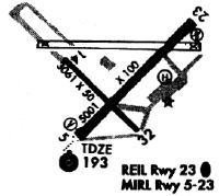
Runways
Runway Summary
| Runways: | 05/23 |
| Longest Runway: | 05/23 is 5002 ft (1525 m) long |
| Runways with an Instrument Approach: | 05 |
PTB Airport Runway Details
| Runway 05/23 | 5002 ft x 100 ft (1525 m x 30 m) | |
| Runway Length Source: | 3RD PARTY SURVEY as of 10/27/2021 | |
| Surface: | Asphalt - Good condition - Saw-cut or plastic grooved | |
| Runway Edge Lights: | Medium Intensity | |
Runway Weight Bearing Capacity (in thousands of pounds) |
||
| Single Wheel Landing Gear: | 25.0 | |
Runway 05 |
Runway 23 |
|
Elevation: |
192.7 | 189.8 |
Latitude: |
37-10-45.3750N | 37-11-21.5944N |
Longitude: |
077-30-43.2675W | 077-30-01.1863W |
|
Runway True Alignment: |
043 | 223 |
ILS Type: |
LOC/DME | |
Glide Path Angle: |
3.0 degrees | 3.0 degrees |
Traffic Pattern: |
Left | Left |
Runway Markings Type: |
Nonprecision Instrument | Nonprecision Instrument |
Runway Markings Condition: |
Good | Good |
Object at End: |
TREE | TREE |
Object Height: |
35 | 71 |
Distance from End: |
1117 | 3432 |
Object Centerline Offset: |
227 ft. left of centerline | 325 ft. right of centerline |
Visual Glide Slope Indicators: |
4-Light PAPI On Left Side Of Runway | 4-Light PAPI On Left Side Of Runway |
Approach Light System: |
Omnidirectional Approach Lighting System | |
REIL: |
No | Yes |
Threshold Crossing Height: |
42 | 40 |
Services
Airframe Repair: |
Major |
Powerplant Repair: |
Major |
Bottled Oxygen: |
None |
Bulk Oxygen: |
None |
Fuel Available: |
100LL, Jet A-1+ |
Landing Fees: |
No |
Parking: |
Tiedowns available |
Maps & Diagrams
PTB Sectional
Flight Planning
at skyvector.com
at skyvector.com