Location
Latitude: |
38-21-08.6170N (38.352394) |
Longitude: |
097-41-28.6740W (-97.691298) |
Elevation: |
1498.3 feet MSL (457 m MSL) |
Magnetic Variation: |
3.3 E (as of April 2024 from WMM2020 model) |
Time Zone: |
UTC -6.0 (Standard Time) UTC -5.0 (Daylight Savings Time) |
From City: |
01 N.M. SW of Mc Pherson, Kansas |
Found On: |
Wichita Chart |
FAA Region: |
ACE |
Contacts
Manager: |
Publicly owned: |
| CYNTHIA PETERSON 1000 S. 81 BYPASS MC PHERSON, KS 67460 620-241-0684 |
COUNTY & CITY OF MC PHERSON 400 EAST KANSAS MC PHERSON, KS 67460 (620) 245-2535 |
Operations
Airport Status: |
Operational |
Facility Use: |
Public |
Type: |
Airport |
Activation Date: |
09/1946 |
Control tower: |
No |
Attendance (Months/Days/Hours): |
Months/Days/Hours ALL/SAT/0800-1200 |
Boundary ARTCC: |
ZKC (Kansas City) |
Responsible ARTCC: |
ZKC (Kansas City) |
Lighting Schedule: |
SEE RMK |
Segmented Circle Indicator: |
Yes |
Traffic Pattern Altitude (MSL): |
2498 feet (761 m) |
NOTAMs Facility: |
ICT |
NOTAM-D Service: |
Yes |
International Airport of Entry: |
No |
Customs Landing Rights: |
No |
Military Landing Rights: |
Yes |
Civil/Military Joint Use: |
No |
Based Aircraft
| Single Engine: | 21 |
| Multi Engine: | 1 |
Annual Operations (as of 07/31/2022)
| Total Operations: | 5568 | |
| GA Local: | 4056 | 72.8% |
| GA Itinerant: | 1200 | 21.6% |
| Military Aircraft: | 312 | 5.6% |
Communications
| CTAF: | 122.800 |
| Unicom: | 122.800 |
| Approach: | WICHITA 125.5 125.5 |
| Departure: | WICHITA 125.5 125.5 |
| AWOS-3P: | 119.025 (620-798-1650) |
Fixed Based Operators (FBOs) & Fuel
(Click on a business for detail)
Please help us keep this information up to date. This is a FREE SERVICE just like everything else on Airport Guide! If you see that a business needs to be added, modified, or deleted please fill out our Update Form.
To add, modify, or delete a business click here.
Please help us keep this information up to date. This is a FREE SERVICE just like everything else on Airport Guide! If you see that a business needs to be added, modified, or deleted please fill out our Update Form.
Area Code: 620 |
| Business Name | Frequency | Phone | Fuel Grade |
|---|---|---|---|
| Mac Air Corp
Update FBO info |
Unicom 122.8 | 241-0684 | 100LL, Jet A, MOGAS |
Flight Service Stations
| Primary | Alternate | |
| FSS on Field: | N | |
| FSS Name (ID): | Wichita(ICT) | |
| Frequency: | ||
| Toll Free Phone: | 1-800-WX-BRIEF |
Instrument Procedures / Charts
FAA Terminal Procedures valid from 0901Z 03/21/24 to 0901Z 04/18/24.
There are various types of charts available for an airport. They are listed in the Page Type column. Here is a legend for those types:
APD - Airport Diagram
DP - Departure Procedure Charts
HOT - Hot Spots
IAP - Instrument Approach Procedure Charts
MIN - Minimums
STAR - Standard Terminal Arrival Charts
| Page Type | Page Name | Volume | Action Since Last Cycle |
|---|---|---|---|
| IAP | RNAV (GPS) RWY 18 | NC-2 | |
| IAP | RNAV (GPS) RWY 36 | NC-2 | |
| IAP | VOR RWY 36 | NC-2 | |
| MIN | TAKEOFF MINIMUMS | NC-2 |
Terminal Procedures are only available for airports in several countries with more being added all the time. If you are looking for a specific country's charts, please send an email to support(at)airportguide.com stating the country name. This will be used to prioritize the implementation.
Navigation Aids (Navaids) near MPR
| Dist (NM) | ID | Morse Code | Name | Type | Freq | True Hdg | Mag Hdg |
|---|---|---|---|---|---|---|---|
| 0.3 | MPR | _ _ . _ _ . . _ . | Mc Pherson | NDB | 227 | 141 | 138 |
| 17.7 | HU | . . . . . . _ | Saltt | NDB | 404 | 219 | 216 |
| 19.9 | SL | . . . . _ . . | Flory | NDB | 344 | 6 | 3 |
| 23.2 | CA | _ . _ . . _ | Harvs | NDB | 395 | 122 | 119 |
| 24.2 | HUT | . . . . . . _ _ | Hutchinson | VOR-DME | 116.80 | 208 | 205 |
| 25.2 | LYO | . _ . . _ . _ _ _ _ _ | Lyons | NDB | 386 | 269 | 266 |
| 26.2 | EWK | . . _ _ _ . _ | Newton | NDB | 281 | 131 | 128 |
| 34.5 | SLN | . . . . _ . . _ . | Salina | VORTAC | 117.10 | 5 | 2 |
| 36.8 | ICT | . . _ . _ . _ | Wichita | VORTAC | 113.80 | 172 | 169 |
| 44.6 | ICT | . . _ . _ . _ | Wichita | VOT | 114.00 | 164 | 161 |
| 46.1 | HRU | . . . . . _ . . . _ | Herington | NDB | 407 | 63 | 60 |
| 47.8 | IC | . . _ . _ . | Piche | NDB | 332 | 166 | 163 |
| 48.2 | IAB | . . . _ _ . . . | Mc Connell | TACAN | 116.50 | 155 | 152 |
| 53.7 | FRI | . . _ . . _ . . . | Fort Riley | VOR | 109.40 | 46 | 43 |
| 55.2 | GB | _ _ . _ . . . | Babsy | NDB | 419 | 264 | 260 |
| 57.0 | HIL | . . . . . . . _ . . | Hilyn | NDB | 338 | 270 | 266 |
| 58.3 | CVY | _ . _ . . . . _ _ . _ _ | Cavalry | NDB | 314 | 45 | 42 |
| 62.5 | PTT | . _ _ . _ _ | Pratt | NDB | 356 | 233 | 229 |
| 63.3 | EGT | . _ _ . _ | Wellington | NDB | 414 | 166 | 163 |
| 66.4 | LQR | . _ . . _ _ . _ . _ . | Larned | NDB | 296 | 262 | 258 |
Nearby Airports with Fuel
Notices to Airmen (NOTAMS)
Remarks
| A110-1 | PHONE AVBL 24 HRS. |
| A110-2 | +300 FOOT CONSTRUCTION CRANES OCCASIONALLY AT REFINERY .9 MILES EAST SOUTHEAST OF AIRPORT |
| A110-3 | AWOS (620) 241-2498 FREQ. 119.025 |
| A110-4 | FOR CD IF UNA TO CTC ON FSS FREQ, CTC WICHITA APPCH AT 316-350-1520 |
| A33-18/36 | PORTIONS OF TWYS & TIE DOWN AREAS ARE A COMBINATION OF CONCRETE & ASPHALT. |
| A42-08 | RWY 08 THLD AND EDGE DELINEATED BY YELLOW CONES. |
| A42-26 | RWY 26 THLD AND EDGE DELINEATED WITH YELLOW CONES. |
| A70-FUEL-10 | 0LL 100LL IS AVBL BY USE OF CREDIT CARD. JET A AND MO GAS AFTER HOURS CALL MANAGER 620-755-8901 |
| A81-APT | MIRL RY 18/36 PRESET ON LOW INTST TO INCREASE INTST ACTVT - CTAF. |
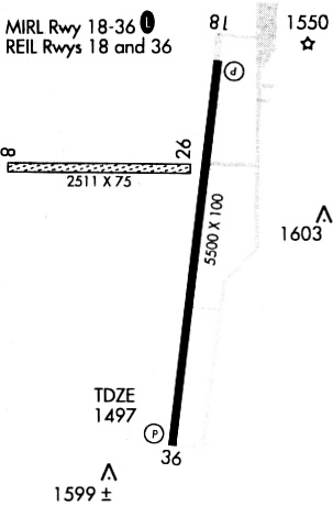
Runways
Runway Summary
| Runways: | 08/26 18/36 |
| Longest Runway: | 18/36 is 5503 ft (1677 m) long |
| Runways with an Instrument Approach: |
MPR Airport Runway Details
| Runway 08/26 | 2502 ft x 75 ft (763 m x 23 m) | |
| Runway Length Source: | 3RD PARTY SURVEY as of 09/30/2020 | |
| Surface: | Turf - Good condition - No special surface treatment | |
Runway 08 |
Runway 26 |
|
Elevation: |
1494.1 | 1493.2 |
Latitude: |
38-21-17.4227N | 38-21-17.6175N |
Longitude: |
097-41-55.4050W | 097-41-24.0018W |
|
Runway True Alignment: |
090 | 270 |
Glide Path Angle: |
0.0 degrees | 0.0 degrees |
Traffic Pattern: |
Left | Right |
Runway Markings Condition: |
Good | Good |
REIL: |
No | No |
Touchdown Lights: |
No | No |
Centerline Lights: |
No | No |
| Runway 18/36 | 5503 ft x 100 ft (1677 m x 30 m) | |
| Runway Length Source: | 3RD PARTY SURVEY as of 09/30/2020 | |
| Surface: | Turf - Good condition - No special surface treatment | |
| Runway Pavement Class: | 11 /R/C/X/U | |
| Runway Edge Lights: | Medium Intensity | |
Runway Weight Bearing Capacity (in thousands of pounds) |
||
| Single Wheel Landing Gear: | 30.0 | |
Runway 18 |
Runway 36 |
|
Elevation: |
1493.8 | 1494.8 |
Latitude: |
38-21-31.6335N | 38-20-37.5032N |
Longitude: |
097-41-20.2923W | 097-41-27.0255W |
|
Runway True Alignment: |
186 | 006 |
Glide Path Angle: |
3.0 degrees | 3.0 degrees |
Traffic Pattern: |
Right | Left |
Runway Markings Type: |
Nonprecision Instrument | Nonprecision Instrument |
Runway Markings Condition: |
Fair | Fair |
Visual Glide Slope Indicators: |
4-Light PAPI On Left Side Of Runway | 4-Light PAPI On Left Side Of Runway |
REIL: |
Yes | Yes |
Touchdown Lights: |
No | No |
Centerline Lights: |
No | No |
Threshold Crossing Height: |
41 | 39 |
Services
Airframe Repair: |
Major |
Powerplant Repair: |
Major |
Bottled Oxygen: |
None |
Bulk Oxygen: |
None |
Fuel Available: |
100LL, Jet A |
Landing Fees: |
No |
Parking: |
Hangars and tiedowns available |
Maps & Diagrams
MPR Sectional
Flight Planning
at skyvector.com
at skyvector.com