Location
Latitude: |
43-46-29.3590N (43.774822) |
Longitude: |
098-02-19.0150W (-98.038615) |
Elevation: |
1304.4 feet MSL (398 m MSL) |
Magnetic Variation: |
3.6 E (as of April 2024 from WMM2020 model) |
Time Zone: |
UTC -6.0 (Standard Time) UTC -5.0 (Daylight Savings Time) |
From City: |
03 N.M. N of Mitchell, South Dakota |
Found On: |
Omaha Chart |
FAA Region: |
AGL |
Contacts
Manager: |
Publicly owned: |
| MIKE SCHERSCHLIGT 621 WEST 5TH MITCHELL, SD 57301 605-770-4594 |
CITY OF MITCHELL 612 N MAIN ST. MITCHELL, SD 57301 605-995-8420 |
Operations
Airport Status: |
Operational |
Facility Use: |
Public |
Type: |
Airport |
Activation Date: |
11/1937 |
Control tower: |
No |
Attendance (Months/Days/Hours): |
Months/Days/Hours ALL/ALL/0800-1800 |
Boundary ARTCC: |
ZMP (Minneapolis) |
Responsible ARTCC: |
ZMP (Minneapolis) |
Lighting Schedule: |
SEE RMK |
Segmented Circle Indicator: |
Yes |
Traffic Pattern Altitude (MSL): |
2304 feet (702 m) |
NOTAMs Facility: |
MHE |
NOTAM-D Service: |
Yes |
International Airport of Entry: |
No |
Customs Landing Rights: |
No |
Military Landing Rights: |
Yes |
Civil/Military Joint Use: |
No |
Based Aircraft
| Single Engine: | 24 |
| Multi Engine: | 3 |
| Jet Engine: | 2 |
| GA Helicopters: | 2 |
Annual Operations (as of 09/27/2023)
| Total Operations: | 14940 | |
| Air Taxi: | 580 | 3.9% |
| GA Local: | 9100 | 60.9% |
| GA Itinerant: | 5200 | 34.8% |
| Military Aircraft: | 60 | 0.4% |
Communications
| CTAF: | 122.800 |
| Unicom: | 122.800 |
| ASOS: | 124.175 (605-995-5803) |
- COMMUNICATIONS PRVDD BY HURON RADIO FREQ 122.3 (MITCHELL RCO).
- APCH/DEP SVC PRVDD BY MINNEAPOLIS ARTCC (ZMP) ON FREQ 126.25/339.8 (HURON RCAG).
Fixed Based Operators (FBOs) & Fuel
(Click on a business for detail)
Please help us keep this information up to date. This is a FREE SERVICE just like everything else on Airport Guide! If you see that a business needs to be added, modified, or deleted please fill out our Update Form.
To add, modify, or delete a business click here.
Please help us keep this information up to date. This is a FREE SERVICE just like everything else on Airport Guide! If you see that a business needs to be added, modified, or deleted please fill out our Update Form.
Area Code: 605 |
| Business Name | Frequency | Phone | Fuel Grade |
|---|---|---|---|
| Wright Bros. Aviation
Update FBO info |
Unicom 122.8 | 996-1228 | 100LL, Jet A |
Flight Service Stations
| Primary | Alternate | |
| FSS on Field: | N | |
| FSS Name (ID): | Huron(HON) | |
| Frequency: | ||
| Toll Free Phone: | 1-800-WX-BRIEF |
Instrument Procedures / Charts
FAA Terminal Procedures valid from 0901Z 03/21/24 to 0901Z 04/18/24.
There are various types of charts available for an airport. They are listed in the Page Type column. Here is a legend for those types:
APD - Airport Diagram
DP - Departure Procedure Charts
HOT - Hot Spots
IAP - Instrument Approach Procedure Charts
MIN - Minimums
STAR - Standard Terminal Arrival Charts
| Page Type | Page Name | Volume | Action Since Last Cycle |
|---|---|---|---|
| IAP | ILS OR LOC RWY 31 | NC-1 | |
| IAP | RNAV (GPS) RWY 13 | NC-1 | |
| IAP | RNAV (GPS) RWY 18 | NC-1 | |
| IAP | RNAV (GPS) RWY 31 | NC-1 | |
| IAP | RNAV (GPS) RWY 36 | NC-1 | |
| IAP | VOR RWY 13 | NC-1 | |
| MIN | ALTERNATE MINIMUMS | NC-1 | |
| MIN | TAKEOFF MINIMUMS | NC-1 |
Terminal Procedures are only available for airports in several countries with more being added all the time. If you are looking for a specific country's charts, please send an email to support(at)airportguide.com stating the country name. This will be used to prioritize the implementation.
Navigation Aids (Navaids) near MHE
| Dist (NM) | ID | Morse Code | Name | Type | Freq | True Hdg | Mag Hdg |
|---|---|---|---|---|---|---|---|
| 0.1 | MHE | _ _ . . . . . | Mitchell | VOR-DME | 109.20 | 18 | 14 |
| 41.6 | HON | . . . . _ _ _ _ . | Huron | DME | 117.6 | 343 | 339 |
| 42.1 | HO | . . . . _ _ _ | Beady | NDB | 302 | 342 | 338 |
| 43.5 | MDS | _ _ _ . . . . . | Wentworth | NDB | 400 | 70 | 67 |
| 44.1 | AGZ | . _ _ _ . _ _ . . | Wagner | NDB | 392 | 194 | 190 |
| 55.1 | FSD | . . _ . . . . _ . . | Sioux Falls | VORTAC | 115.00 | 97 | 94 |
| 55.2 | FS | . . _ . . . . | Rokky | NDB | 245 | 107 | 104 |
| 58.5 | BK | _ . . . _ . _ | Chrlz | NDB | 335 | 53 | 50 |
| 58.8 | YKN | _ . _ _ _ . _ _ . | Yankton | DME | 111.4 | 150 | 147 |
| 61.6 | BKX | _ . . . _ . _ _ . . _ | Brookings | VOR-DME | 108.80 | 58 | 55 |
| 64.5 | YK | _ . _ _ _ . _ | Cagur | NDB | 347 | 149 | 146 |
| 72.6 | AT | . _ _ | Lican | NDB | 215 | 31 | 28 |
| 76.8 | ISD | . . . . . _ . . | Winner | VOR | 112.80 | 257 | 253 |
| 81.9 | ATY | . _ _ _ . _ _ | Watertown | TACAN | 116.60 | 27 | 24 |
| 83.2 | ONL | _ _ _ _ . . _ . . | O'neill | VORTAC | 113.90 | 200 | 196 |
| 89.3 | SOY | . . . _ _ _ _ . _ _ | Sioux Center | NDB | 368 | 114 | 111 |
| 97.5 | AB | . _ _ . . . | Reney | NDB | 203 | 352 | 348 |
| 98.3 | ORC | _ _ _ . _ . _ . _ . | Orange City | NDB | 521 | 117 | 114 |
| 98.6 | RBE | . _ . _ . . . . | Rock County | NDB | 341 | 223 | 219 |
| 98.8 | PIR | . _ _ . . . . _ . | Pierre | VORTAC | 113.75 | 292 | 288 |
Nearby Airports with Fuel
Notices to Airmen (NOTAMS)
Remarks
| A110-1 | MIGRATORY BIRDS ON & INVOF ARPT. |
| A110-2 | ULTRALGT ACTVT ON & INVOF ARPT. |
| A110-3 | FOR CD IF UNA TO CTC ON FSS FREQ, CTC MINNEAPOLIS ARTCC AT 651-463-5588. |
| A17 | FOR ATTENDANT OTHER HRS CALL 605-996-1228. |
| A70-FUEL-10 | 0LL FUEL AVBL 24 HRS A DAY. |
| A81-APT | ACTVT MALSR RWY 31, REIL RWY 13 & 18, PAPI RWY 13, 31, 18 & 36 , HIRL RWY 13/31; MIRL RWY 18/36 - CTAF. |
Runways
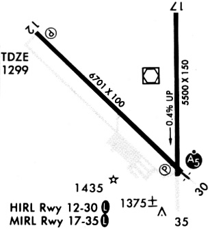
Runway Summary
| Runways: | 13/31 18/36 |
| Longest Runway: | 13/31 is 6701 ft (2042 m) long |
| Runways with an Instrument Approach: | 31 |
MHE Airport Runway Details
| Runway 13/31 | 6701 ft x 100 ft (2042 m x 30 m) | |
| Runway Length Source: | 3RD PARTY SURVEY as of 08/20/2020 | |
| Surface: | Asphalt - Good condition - No special surface treatment | |
| Runway Edge Lights: | High Intensity | |
Runway Weight Bearing Capacity (in thousands of pounds) |
||
| Single Wheel Landing Gear: | 55.0 | |
| Dual Wheel Landing Gear: | 90.0 | |
| Dual Tandem Wheel Landing Gear: | 120.0 | |
Runway 13 |
Runway 31 |
|
Elevation: |
1296.1 | 1303.6 |
Latitude: |
43-46-51.4104N | 43-46-05.1042N |
Longitude: |
098-03-05.4526W | 098-02-00.2223W |
|
Runway True Alignment: |
134 | 314 |
ILS Type: |
ILS | |
Glide Path Angle: |
3.0 degrees | 3.0 degrees |
Traffic Pattern: |
Left | Left |
Runway Markings Type: |
Precision Instrument | Precision Instrument |
Runway Markings Condition: |
Good | Good |
Visual Glide Slope Indicators: |
4-Light PAPI On Left Side Of Runway | 4-Light PAPI On Left Side Of Runway |
Approach Light System: |
1,400 Foot Medium Intensity Approach Lighting System With Runway Alignment Indicator Lights | |
REIL: |
Yes | |
Touchdown Lights: |
No | No |
Centerline Lights: |
No | No |
Threshold Crossing Height: |
45 | 61 |
| Runway 18/36 | 5513 ft x 100 ft (1680 m x 30 m) | |
| Runway Length Source: | 3RD PARTY SURVEY as of 08/20/2020 | |
| Surface: | Asphalt - Good condition - Porous friction course | |
| Runway Edge Lights: | Medium Intensity | |
Runway Weight Bearing Capacity (in thousands of pounds) |
||
| Single Wheel Landing Gear: | 35.0 | |
| Dual Wheel Landing Gear: | 90.0 | |
| Dual Tandem Wheel Landing Gear: | 110.0 | |
Runway 18 |
Runway 36 |
|
Elevation: |
1282.8 | 1303.0 |
Latitude: |
43-46-57.9157N | 43-46-03.4778N |
Longitude: |
098-02-02.5069W | 098-02-01.9289W |
|
Runway True Alignment: |
180 | 360 |
Glide Path Angle: |
3.0 degrees | 3.0 degrees |
Traffic Pattern: |
Left | Left |
Runway Markings Type: |
Nonprecision Instrument | Nonprecision Instrument |
Runway Markings Condition: |
Fair | Fair |
Visual Glide Slope Indicators: |
4-Light PAPI On Left Side Of Runway | 4-Light PAPI On Left Side Of Runway |
REIL: |
Yes | No |
Touchdown Lights: |
No | No |
Centerline Lights: |
No | No |
Threshold Crossing Height: |
55 | 50 |
Services
Airframe Repair: |
None |
Powerplant Repair: |
None |
Bottled Oxygen: |
None |
Bulk Oxygen: |
None |
Fuel Available: |
100LL, Jet A |
Landing Fees: |
No |
Parking: |
Hangars and tiedowns available |
Maps & Diagrams
MHE Sectional
Flight Planning
at skyvector.com
at skyvector.com