Location
Latitude: |
36-32-12.1000N (36.536694) |
Longitude: |
086-55-16.2000W (-86.921167) |
Elevation: |
706.3 feet MSL (215 m MSL) |
Magnetic Variation: |
4.1 W (as of April 2024 from WMM2020 model) |
Time Zone: |
UTC -6.0 (Standard Time) UTC -5.0 (Daylight Savings Time) |
From City: |
03 N.M. NW of Springfield, Tennessee |
Found On: |
St Louis Chart |
FAA Region: |
ASO |
Contacts
Manager: |
Publicly owned: |
| BRIAN URBACH 4432 AIRPORT RD SPRINGFIELD, TN 37172 615-985-4432 |
SPRINGFIELD/ROBERTSON AIRPORT BOARD P.O.BOX 1125 SPRINGFIELD, TN 37172-1125 615-985-4432 |
Operations
Airport Status: |
Operational |
Facility Use: |
Public |
Type: |
Airport |
Activation Date: |
12/1964 |
Control tower: |
No |
Attendance (Months/Days/Hours): |
Months/Days/Hours APR-OCT/MON-SAT/0800-1700 |
Boundary ARTCC: |
ZME (Memphis) |
Responsible ARTCC: |
ZME (Memphis) |
Lighting Schedule: |
SEE RMK |
Segmented Circle Indicator: |
Yes |
Traffic Pattern Altitude (MSL): |
1706 feet (520 m) |
NOTAMs Facility: |
BNA |
NOTAM-D Service: |
Yes |
International Airport of Entry: |
No |
Customs Landing Rights: |
No |
Military Landing Rights: |
Yes |
Civil/Military Joint Use: |
No |
Based Aircraft
| Single Engine: | 51 |
| Multi Engine: | 4 |
| GA Helicopters: | 8 |
Annual Operations (as of 06/30/2019)
| Total Operations: | 14300 | |
| Air Taxi: | 500 | 3.5% |
| GA Local: | 6000 | 42.0% |
| GA Itinerant: | 6000 | 42.0% |
| Military Aircraft: | 1800 | 12.6% |
Communications
| CTAF: | 123.000 |
| Unicom: | 123.000 |
| Approach: | NASHVILLE 119.35 119.35 |
| Departure: | NASHVILLE 119.35 119.35 |
| AWOS-3: | 120.675 (615-384-8206) |
Fixed Based Operators (FBOs) & Fuel
(Click on a business for detail)
Please help us keep this information up to date. This is a FREE SERVICE just like everything else on Airport Guide! If you see that a business needs to be added, modified, or deleted please fill out our Update Form.
To add, modify, or delete a business click here.
Please help us keep this information up to date. This is a FREE SERVICE just like everything else on Airport Guide! If you see that a business needs to be added, modified, or deleted please fill out our Update Form.
Area Code: 615 |
| Business Name | Frequency | Phone | Fuel Grade |
|---|---|---|---|
| Springfield-Robertson County Joint Airport Board
Website Update FBO info |
(615) 985-4432 | 100LL, Jet A | |

|
AvFuel | 100LL - 4.15 USD per gallon on 1/12/2020 |
24 Hour Self-Serve Credit Card Pumps Discount for purchase of over 500 gallons of 100LL/month |
|
|
AvFuel | Jet A - 4.05 USD per gallon on 1/12/2020 |
24 Hour Self-Serve Credit Card Pumps Discount for purchase of over 500 gallons of 100LL/month |
Flight Service Stations
| Primary | Alternate | |
| FSS on Field: | N | |
| FSS Name (ID): | Nashville(BNA) | |
| Frequency: | ||
| Toll Free Phone: | 1-800-WX-BRIEF |
Instrument Procedures / Charts
FAA Terminal Procedures valid from 0901Z 03/21/24 to 0901Z 04/18/24.
There are various types of charts available for an airport. They are listed in the Page Type column. Here is a legend for those types:
APD - Airport Diagram
DP - Departure Procedure Charts
HOT - Hot Spots
IAP - Instrument Approach Procedure Charts
MIN - Minimums
STAR - Standard Terminal Arrival Charts
| Page Type | Page Name | Volume | Action Since Last Cycle |
|---|---|---|---|
| IAP | LOC RWY 04 | SE-1 | |
| IAP | RNAV (GPS) RWY 04 | SE-1 | |
| IAP | RNAV (GPS) RWY 22 | SE-1 | |
| MIN | TAKEOFF MINIMUMS | SE-1 |
Terminal Procedures are only available for airports in several countries with more being added all the time. If you are looking for a specific country's charts, please send an email to support(at)airportguide.com stating the country name. This will be used to prioritize the implementation.
Navigation Aids (Navaids) near M91
| Dist (NM) | ID | Morse Code | Name | Type | Freq | True Hdg | Mag Hdg |
|---|---|---|---|---|---|---|---|
| 5.5 | ON | _ _ _ _ . | Music | NDB | 279 | 213 | 217 |
| 22.5 | CK | _ . _ . _ . _ | Snuff | NDB | 335 | 268 | 272 |
| 23.8 | VI | . . . _ . . | Opery | NDB | 344 | 146 | 150 |
| 24.2 | CKV | _ . _ . _ . _ . . . _ | Clarksville | VOR-DME | 110.60 | 282 | 286 |
| 26.6 | BNA | _ . . . _ . . _ | Nashville | VORTAC | 114.10 | 154 | 158 |
| 26.6 | FK | . . _ . _ . _ | Airbe | NDB | 273 | 297 | 301 |
| 28.3 | BNA | _ . . . _ . . _ | Nashville Metropoln | VOT | 108.60 | 153 | 157 |
| 28.8 | HIX | . . . . . . _ . . _ | Honey Grove | NDB | 356 | 315 | 319 |
| 29.4 | HXW | . . . . _ . . _ . _ _ | Screaming Eagle | TACAN | 114.90 | 284 | 288 |
| 29.5 | BW | _ . . . . _ _ | Noora | NDB | 236 | 45 | 49 |
| 32.9 | BWG | _ . . . . _ _ _ _ . | Bowling Green | DME | 117.9 | 44 | 48 |
| 34.8 | DMZ | _ . . _ _ _ _ . . | Dickson | NDB | 203 | 225 | 229 |
| 35.9 | JUE | . _ _ _ . . _ . | Lebanon | NDB | 414 | 124 | 128 |
| 37.5 | MQY | _ _ _ _ . _ _ . _ _ | Smyrna | VOT | 110.20 | 147 | 151 |
| 41.2 | SWZ | . . . . _ _ _ _ . . | Sewart | NDB | 391 | 147 | 151 |
| 43.0 | GMH | _ _ . _ _ . . . . | Muhlenberg | NDB | 362 | 344 | 348 |
| 43.6 | FQW | . . _ . _ _ . _ . _ _ | Walter Hill | NDB | 371 | 142 | 146 |
| 47.0 | AEY | . _ . _ . _ _ | Waverly | NDB | 329 | 237 | 241 |
| 49.4 | GHM | _ _ . . . . . _ _ | Graham | DME | 111.6 | 211 | 215 |
| 52.5 | BVQ | _ . . . . . . _ _ _ . _ | Beaver Creek | NDB | 260 | 56 | 60 |
Nearby Airports with Fuel
Notices to Airmen (NOTAMS)
Remarks
| A110-1 | FOR CD CTC NASHVILLE APCH AT 615-367-1224. . |
| A110-2 | DEP CLIMB TO 500 FT BFR TURN. |
| A110-3 | AFT HR SVC - 615-985-4432. |
| A110-4 | FLT TRNG INVOF ARPT. |
| A110-5 | AFT HR ACES - UNICOM. |
| A110-6 | CREDIT CARD FUEL AVBL H24. |
| A17 | CLSD SUN & FED HOL. |
| A30A-22 | CALM WIND RWY. |
| A81-APT | ACTVT REIL RWY 04 & 22; MIRL RWY 04/22 - CTAF. MIRL RWY 04/22 PRESET TO LOW INTST; INCR INTST - CTAF. |
| E111 | VFR ONLY. |
Runways
Runway Summary
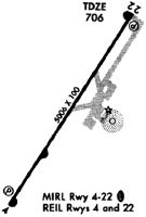
| Runways: | 04/22 |
| Longest Runway: | 04/22 is 5505 ft (1678 m) long |
| Runways with an Instrument Approach: | 04 |
M91 Airport Runway Details
| Runway 04/22 | 5505 ft x 100 ft (1678 m x 30 m) | |
| Runway Length Source: | 3RD PARTY SURVEY as of 11/11/2011 | |
| Surface: | Asphalt - Good condition - No special surface treatment | |
| Runway Pavement Class: | 7 /F/D/X/T | |
| Runway Edge Lights: | Medium Intensity | |
Runway Weight Bearing Capacity (in thousands of pounds) |
||
| Single Wheel Landing Gear: | 38.0 | |
| Dual Wheel Landing Gear: | 52.0 | |
Runway 04 |
Runway 22 |
|
Elevation: |
700.5 | 706.3 |
Latitude: |
36-31-49.4280N | 36-32-34.7513N |
Longitude: |
086-55-34.8498W | 086-54-57.4938W |
|
Runway True Alignment: |
034 | 214 |
ILS Type: |
LOCALIZER | |
Glide Path Angle: |
3.0 degrees | 3.0 degrees |
Traffic Pattern: |
Left | |
Runway Markings Type: |
Nonprecision Instrument | Nonprecision Instrument |
Runway Markings Condition: |
Good | Good |
Object at End: |
TREES | |
Object Height: |
70 | 46 |
Distance from End: |
2184 | 1149 |
Object Centerline Offset: |
159 ft. left of centerline | 200 ft. left of centerline |
Visual Glide Slope Indicators: |
2-Light PAPI On Left Side Of Runway | 2-Light PAPI On Left Side Of Runway |
REIL: |
Yes | Yes |
Threshold Crossing Height: |
40 | 60 |
Services
Airframe Repair: |
Major |
Powerplant Repair: |
Major |
Fuel Available: |
100LL, Jet A+ |
Landing Fees: |
No |
Parking: |
Hangars and tiedowns available |
Maps & Diagrams
M91 Sectional
Flight Planning
at skyvector.com
at skyvector.com