Location
Latitude: |
34-26-50.9600N (34.447489) |
Longitude: |
079-53-11.1270W (-79.886424) |
Elevation: |
192.2 feet MSL (59 m MSL) |
Magnetic Variation: |
8.5 W (as of April 2024 from WMM2020 model) |
Time Zone: |
UTC -5.0 (Standard Time) UTC -4.0 (Daylight Savings Time) |
From City: |
09 N.M. N of Darlington, South Carolina |
Found On: |
Charlotte Chart |
FAA Region: |
ASO |
Contacts
Manager: |
Publicly owned: |
| BARRY KENNETT 313 G.GRAHAM SEGARS PARKWAY DARLINGTON, SC 29540 843-393-9928 |
DARLINGTON COUNTY COUNTY COURTHOUSE DARLINGTON, SC 29532 (843) 393-4100 |
Operations
Airport Status: |
Operational |
Facility Use: |
Public |
Type: |
Airport |
Activation Date: |
10/1943 |
Control tower: |
No |
Attendance (Months/Days/Hours): |
Months/Days/Hours ALL/MON-FRI/0800-1700 |
Boundary ARTCC: |
ZJX (Jacksonville) |
Responsible ARTCC: |
ZJX (Jacksonville) |
Lighting Schedule: |
SEE RMK |
Segmented Circle Indicator: |
Yes |
Traffic Pattern Altitude (MSL): |
1192 feet (363 m) |
NOTAMs Facility: |
UDG |
NOTAM-D Service: |
Yes |
International Airport of Entry: |
No |
Customs Landing Rights: |
No |
Military Landing Rights: |
No |
Civil/Military Joint Use: |
No |
Based Aircraft
| Single Engine: | 9 |
| Jet Engine: | 2 |
Annual Operations (as of 09/26/2023)
| Total Operations: | 6100 | |
| Air Taxi: | 508 | 8.3% |
| GA Local: | 3661 | 60.0% |
| GA Itinerant: | 1831 | 30.0% |
| Military Aircraft: | 100 | 1.6% |
Communications
| CTAF: | 123.000 |
| Unicom: | 123.000 |
| Clearance Del.: | 118.55 118.55 118.55 |
| Approach: | FLORENCE JAX ARTCC |
| Departure: | FLORENCE JAX ARTCC |
| AWOS-3PT: | 119.925 (843-393-8220) |
- APCH/DEP SVC PRVDD BY JACKSONVILLE ARTCC ON FREQS 133.45/306.3 (FLORENCE RCAG) WHEN FLORENCE APCH CTL CLSD.
Fixed Based Operators (FBOs) & Fuel
(Click on a business for detail)
Please help us keep this information up to date. This is a FREE SERVICE just like everything else on Airport Guide! If you see that a business needs to be added, modified, or deleted please fill out our Update Form.
To add, modify, or delete a business click here.
Please help us keep this information up to date. This is a FREE SERVICE just like everything else on Airport Guide! If you see that a business needs to be added, modified, or deleted please fill out our Update Form.
Area Code: 803 |
| Business Name | Frequency | Phone | Fuel Grade |
|---|---|---|---|
| Darlington County Aviation
Update FBO info |
Unicom 123.0 | 393-2987 | 100LL, Jet A |
Flight Service Stations
| Primary | Alternate | |
| FSS on Field: | N | |
| FSS Name (ID): | Anderson(AND) | |
| Frequency: | ||
| Toll Free Phone: | 1-800-WX-BRIEF |
Instrument Procedures / Charts
FAA Terminal Procedures valid from 0901Z 03/21/24 to 0901Z 04/18/24.
There are various types of charts available for an airport. They are listed in the Page Type column. Here is a legend for those types:
APD - Airport Diagram
DP - Departure Procedure Charts
HOT - Hot Spots
IAP - Instrument Approach Procedure Charts
MIN - Minimums
STAR - Standard Terminal Arrival Charts
| Page Type | Page Name | Volume | Action Since Last Cycle |
|---|---|---|---|
| IAP | RNAV (GPS) RWY 05 | SE-2 | |
| IAP | RNAV (GPS) RWY 23 | SE-2 | |
| IAP | VOR-A | SE-2 | |
| MIN | ALTERNATE MINIMUMS | SE-2 | |
| MIN | TAKEOFF MINIMUMS | SE-2 |
Terminal Procedures are only available for airports in several countries with more being added all the time. If you are looking for a specific country's charts, please send an email to support(at)airportguide.com stating the country name. This will be used to prioritize the implementation.
Navigation Aids (Navaids) near KUDG
| Dist (NM) | ID | Morse Code | Name | Type | Freq | True Hdg | Mag Hdg |
|---|---|---|---|---|---|---|---|
| 0.3 | UDG | . . _ _ . . _ _ . | Darlington | NDB | 245 | 189 | 198 |
| 11.8 | HVS | . . . . . . . _ . . . | Hartsville | NDB | 341 | 258 | 266 |
| 12.8 | BES | _ . . . . . . . | Bennettsville | NDB | 230 | 36 | 45 |
| 16.5 | FL | . . _ . . _ . . | Alcot | NDB | 335 | 174 | 182 |
| 17.2 | FLO | . . _ . . _ . . _ _ _ | Florence | VORTAC | 115.20 | 138 | 147 |
| 17.7 | CQW | _ . _ . _ _ . _ . _ _ | Cheraw | NDB | 409 | 3 | 12 |
| 22.7 | CTF | _ . _ . _ . . _ . | Chesterfield | VOR-DME | 114.55 | 302 | 310 |
| 25.6 | DLC | _ . . . _ . . _ . _ . | Dillon | NDB | 274 | 89 | 98 |
| 27.8 | ME | _ _ . | Maxtn | NDB | 257 | 51 | 60 |
| 28.6 | PYG | . _ _ . _ . _ _ _ _ . | Pageland | NDB | 270 | 308 | 316 |
| 31.6 | MAO | _ _ . _ _ _ _ | Marion | NDB | 388 | 119 | 128 |
| 36.0 | CFY | _ . _ . . . _ . _ . _ _ | Evans | NDB | 420 | 170 | 179 |
| 36.1 | SMS | . . . _ _ . . . | Sumter | NDB | 252 | 220 | 228 |
| 37.5 | JB | . _ _ _ _ . . . | Jigel | NDB | 384 | 80 | 89 |
| 40.0 | HFF | . . . . . . _ . . . _ . | Mackall | NDB | 278 | 29 | 38 |
| 40.3 | SSC | . . . . . . _ . _ . | Shaw | TACAN | 110.10 | 225 | 233 |
| 42.0 | RSY | . _ . . . . _ . _ _ | Robeson | NDB | 359 | 75 | 84 |
| 42.2 | LBT | . _ . . _ . . . _ | Lumberton | VOR | 110.00 | 76 | 85 |
| 43.8 | CKI | _ . _ . _ . _ . . | Kingstree | NDB | 404 | 177 | 185 |
| 46.7 | HEK | . . . . . _ . _ | Stuckey | NDB | 236 | 157 | 166 |
Nearby Airports with Fuel
Notices to Airmen (NOTAMS)
Remarks
| A110-1 | AFTER HRS SERVICE CALL 843-393-9928. |
| A110-2 | FOR CD CTC FLORENCE APCH AT 843-665-0632, WHEN APCH CLSD CTC JACKSONVILLE ARTCC AT 904-845-1592. |
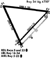
| A81-APT | ODALS RWY 05; MIRL RWY 05/23; AND TWY LGTS PRESET LOW INTST DUSK-2300; TO INCR INTST - CTAF. AFT 2300, ACTVT ODALS RWY 05; REIL RWY 05 & 23; PAPI RWY 05 & 23; MIRL RWY 05/23; AND TWY LGTS - CTAF. |
| E111 | ARPT EXISTED PRIOR TO 1958. |
Runways
Runway Summary
| Runways: | 05/23 |
| Longest Runway: | 05/23 is 5500 ft (1676 m) long |
| Runways with an Instrument Approach: |
KUDG Airport Runway Details
| Runway 05/23 | 5500 ft x 100 ft (1676 m x 30 m) | |
| Runway Length Source: | 3RD PARTY SURVEY as of 01/16/2006 | |
| Surface: | Concrete - Good condition - No special surface treatment | |
| Runway Pavement Class: | 6 /F/C/Y/T | |
| Runway Edge Lights: | Medium Intensity | |
Runway Weight Bearing Capacity (in thousands of pounds) |
||
| Single Wheel Landing Gear: | 17.0 | |
| Dual Wheel Landing Gear: | 27.0 | |
Runway 05 |
Runway 23 |
|
Elevation: |
188.5 | 183.1 |
Latitude: |
34-26-31.2731N | 34-27-10.6448N |
Longitude: |
079-53-33.7886W | 079-52-48.4630W |
|
Runway True Alignment: |
043 | 223 |
Glide Path Angle: |
3.0 degrees | 3.0 degrees |
Traffic Pattern: |
Left | Left |
Runway Markings Type: |
Nonprecision Instrument | Nonprecision Instrument |
Runway Markings Condition: |
Good | Good |
Visual Glide Slope Indicators: |
2-Light PAPI On Left Side Of Runway | 2-Light PAPI On Left Side Of Runway |
Approach Light System: |
Omnidirectional Approach Lighting System | |
REIL: |
Yes | Yes |
Threshold Crossing Height: |
52 | 40 |
Services
Airframe Repair: |
Major |
Powerplant Repair: |
Major |
Bottled Oxygen: |
High Pressure / Low Pressure |
Bulk Oxygen: |
None |
Fuel Available: |
100LL, Jet A-1+ |
Landing Fees: |
No |
Parking: |
Hangars and tiedowns available |
Maps & Diagrams
KUDG Sectional
Flight Planning
at skyvector.com
at skyvector.com