Location
Latitude: |
37-49-33.1150N (37.825865) |
Longitude: |
075-59-51.5850W (-75.997663) |
Elevation: |
5.4 feet MSL (2 m MSL) |
Magnetic Variation: |
11.1 W (as of April 2024 from WMM2020 model) |
Time Zone: |
UTC -5.0 (Standard Time) UTC -4.0 (Daylight Savings Time) |
From City: |
01 N.M. W of Tangier, Virginia |
Found On: |
Washington Chart |
FAA Region: |
AEA |
Contacts
Manager: |
Publicly owned: |
| LAURIE THOMAS PO BOX 244 TANGIER, VA 23440 757-891-2496 |
TOWN OF TANGIER TANGIER ISLAND TANGIER, VA 23440 757-891-2496 |
Operations
Airport Status: |
Operational |
Facility Use: |
Public |
Type: |
Airport |
Control tower: |
No |
Attendance (Months/Days/Hours): |
Months/Days/Hours APR-OCT/SAT-SUN/0800-1630 |
Boundary ARTCC: |
ZDC (Washington) |
Responsible ARTCC: |
ZDC (Washington) |
Segmented Circle Indicator: |
No |
Traffic Pattern Altitude (MSL): |
1005 feet (306 m) |
NOTAMs Facility: |
DCA |
NOTAM-D Service: |
Yes |
International Airport of Entry: |
No |
Customs Landing Rights: |
No |
Military Landing Rights: |
Yes |
Civil/Military Joint Use: |
No |
Based Aircraft
Annual Operations (as of 12/31/2019)
| Total Operations: | 1000 | |
| Air Taxi: | 465 | 46.5% |
| GA Itinerant: | 473 | 47.3% |
| Military Aircraft: | 62 | 6.2% |
Communications
| CTAF: | 122.800 |
| Unicom: | 122.800 |
| Approach: | PATUXENT POTOMAC 127.2 ;WHEN NHK APCH CLSD 127.2 ;WHEN NHK APCH CLSD 127.2 ;WHEN NHK APCH CLSD 127.2 ;WHEN NHK APCH CLSD |
| Departure: | PATUXENT POTOMAC 127.2 ;WHEN NHK APCH CLSD 127.2 ;WHEN NHK APCH CLSD 127.2 ;WHEN NHK APCH CLSD 127.2 ;WHEN NHK APCH CLSD |
| AWOS-3: | 119.8 (757-891-2246) |
- APCH/DEP SVC PRVDD BY POTOMAC TRACON ON 127.2/281.47 WHEN PATUXENT APCH CTL CLSD.
Fixed Based Operators (FBOs) & Fuel
(Click on a business for detail)
Please help us keep this information up to date. This is a FREE SERVICE just like everything else on Airport Guide! If you see that a business needs to be added, modified, or deleted please fill out our Update Form.
To add, modify, or delete a business click here.
Please help us keep this information up to date. This is a FREE SERVICE just like everything else on Airport Guide! If you see that a business needs to be added, modified, or deleted please fill out our Update Form.
Area Code: 757 |
| Business Name | Frequency | Phone | Fuel Grade |
|---|
Flight Service Stations
| Primary | Alternate | |
| FSS on Field: | N | |
| FSS Name (ID): | Leesburg(DCA) | |
| Frequency: | ||
| Toll Free Phone: | 1-800-WX-BRIEF |
Instrument Procedures / Charts
FAA Terminal Procedures valid from 0901Z 03/21/24 to 0901Z 04/18/24.
There are various types of charts available for an airport. They are listed in the Page Type column. Here is a legend for those types:
APD - Airport Diagram
DP - Departure Procedure Charts
HOT - Hot Spots
IAP - Instrument Approach Procedure Charts
MIN - Minimums
STAR - Standard Terminal Arrival Charts
| Page Type | Page Name | Volume | Action Since Last Cycle |
|---|---|---|---|
| IAP | RNAV (GPS)-B | NE-3 | |
| MIN | TAKEOFF MINIMUMS | NE-3 |
Terminal Procedures are only available for airports in several countries with more being added all the time. If you are looking for a specific country's charts, please send an email to support(at)airportguide.com stating the country name. This will be used to prioritize the implementation.
Navigation Aids (Navaids) near KTGI
| Dist (NM) | ID | Morse Code | Name | Type | Freq | True Hdg | Mag Hdg |
|---|---|---|---|---|---|---|---|
| 18.0 | BDB | _ . . . _ . . _ . . . | Accom | NDB | 336 | 148 | 159 |
| 28.7 | CCV | _ . _ . _ . _ . . . . _ | Cape Charles | VORTAC | 112.20 | 180 | 191 |
| 28.8 | SWL | . . . . _ _ . _ . . | Snow Hill | VORTAC | 112.40 | 61 | 72 |
| 33.6 | NHK | _ . . . . . _ . _ | Nas Patuxent River | TACAN | 110.25 | 324 | 335 |
| 33.6 | NHK | _ . . . . . _ . _ | Patuxent | NDB | 400 | 325 | 336 |
| 33.6 | PXT | . _ _ . _ . . _ _ | Patuxent | VORTAC | 117.60 | 325 | 336 |
| 38.7 | SBY | . . . _ . . . _ . _ _ | Salisbury | VORTAC | 111.20 | 36 | 47 |
| 40.8 | HCM | . . . . _ . _ . _ _ | Harcum | VORTAC | 108.80 | 236 | 247 |
| 42.7 | CGE | _ . _ . _ _ . . | Cambridge | NDB | 355 | 357 | 368 |
| 47.6 | LFI | . _ . . . . _ . . . | Langley | TACAN | 112.30 | 201 | 212 |
| 47.8 | PJS | . _ _ . . _ _ _ . . . | Henry | NDB | 375 | 209 | 220 |
| 49.6 | OX | _ _ _ _ . . _ | Landy | NDB | 407 | 49 | 60 |
| 50.7 | FAF | . . _ . . _ . . _ . | Felker | NDB | 226 | 215 | 226 |
| 54.8 | NGU | _ . _ _ . . . _ | Chambers | TACAN | 113.95 | 194 | 205 |
| 56.9 | ORF | _ _ _ . _ . . . _ . | Norfolk | VORTAC | 116.90 | 189 | 200 |
| 60.1 | NTU | _ . _ . . _ | Oceana | TACAN | 116.60 | 181 | 192 |
| 60.3 | OR | _ _ _ . _ . | Ingle | NDB | 329 | 191 | 202 |
| 61.0 | HPW | . . . . . _ _ . . _ _ | Hopewell | VORTAC | 112.00 | 241 | 252 |
| 63.5 | OTT | _ _ _ _ _ | Nottingham | VORTAC | 113.70 | 326 | 337 |
| 65.8 | RIC | . _ . . . _ . _ . | Richmond | VORTAC | 114.10 | 253 | 264 |
Nearby Airports with Fuel
Notices to Airmen (NOTAMS)
Remarks
| A110-1 | PAEW ADJACENT TO ALL RWYS, TWYS & RAMPS. |
| A110-2 | BE ALERT: RSTD AREA ONE MI WEST OF ARPT; HI-SPEED ACFT DROP BOMBS & FIRE LIVE AMMUNITION IN AREA. |
| A110-3 | LANDING/PARKING FEE TO HELP PAY FOR RECENT RWY REHAB. |
| A110-4 | FOR CD CTC PATUXENT APCH AT 301-342-3740, WHEN PATUXENT APCH IS CLSD CTC POTOMAC APCH AT 866-640-4124. |
| A13 | TOWN OFFICE (757) 891-2438. |
| A17 | ARPT CLSD SS-SR DLY. |
| A42-02 | PREV RWY NRS VSB ON FORMER RWY PAVEMENT. CHEVRONS ON FORMER RWY PAVEMENT POOR. RWY CENTERLINE POOR. |
| A42-20 | TWY LEAD-IN LINES POOR. RWY CENTERLINE POOR. |
| A80 | ARPT BCN OTS INDEFLY. |
| E147 |
Runways
Runway Summary
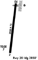
| Runways: | 02/20 |
| Longest Runway: | 02/20 is 2426 ft (739 m) long |
| Runways with an Instrument Approach: |
KTGI Airport Runway Details
| Runway 02/20 | 2426 ft x 75 ft (739 m x 23 m) | |
| Runway Length Source: | ADO as of 11/23/2011 | |
| Surface: | Asphalt - Fair condition - No special surface treatment | |
Runway Weight Bearing Capacity (in thousands of pounds) |
||
| Single Wheel Landing Gear: | 12.5 | |
Runway 02 |
Runway 20 |
|
Elevation: |
5.4 | 4.8 |
Latitude: |
37-49-21.2100N | 37-49-45.0200N |
Longitude: |
075-59-53.4500W | 075-59-49.7200W |
|
Runway True Alignment: |
007 | 187 |
Glide Path Angle: |
0.0 degrees | 0.0 degrees |
Traffic Pattern: |
Right | Left |
Runway Markings Type: |
Basic | Basic |
Runway Markings Condition: |
Poor | Poor |
Object at End: |
TREE | ROAD |
Object Height: |
7 | 15 |
Distance from End: |
380 | 249 |
Object Centerline Offset: |
56 ft. left of centerline | 0 ft. left and right of centerline |
Threshold Elevation: |
5.4 | |
Displaced Threshold: |
183 | |
Threshold Latitude: |
37-49-43.2200N | |
Threshold Longitude: |
075-59-50.0000W |
Services
Airframe Repair: |
Major |
Powerplant Repair: |
Major |
Fuel Available: |
100LL |
Landing Fees: |
Yes |
Parking: |
Tiedowns available |
Maps & Diagrams
KTGI Sectional
Flight Planning
at skyvector.com
at skyvector.com