Location
Latitude: |
41-52-28.0826N (41.874467) |
Longitude: |
071-00-58.7394W (-71.016316) |
Elevation: |
41.5 feet MSL (13 m MSL) |
Magnetic Variation: |
14.1 W (as of April 2024 from WMM2020 model) |
Time Zone: |
UTC -5.0 (Standard Time) UTC -4.0 (Daylight Savings Time) |
From City: |
03 N.M. E of Taunton, Massachusetts |
Found On: |
New York Chart |
FAA Region: |
ANE |
Contacts
Manager: |
Publicly owned: |
| JAY D' ESPINOSA 4 WESTCOAT EAST TAUNTON, MA 02718 508-821-2973 |
CITY OF TAUNTON CITY HALL, 15 SUMMER STREET TAUNTON, MA 02780 508-821-1000 |
Operations
Airport Status: |
Operational |
Facility Use: |
Public |
Type: |
Airport |
Control tower: |
No |
Attendance (Months/Days/Hours): |
Months/Days/Hours ALL/ALL/0800 - 1700 |
Boundary ARTCC: |
ZBW (Boston) |
Responsible ARTCC: |
ZBW (Boston) |
Lighting Schedule: |
SEE RMK |
Segmented Circle Indicator: |
Yes |
Traffic Pattern Altitude (MSL): |
1042 feet (318 m) |
NOTAMs Facility: |
TAN |
NOTAM-D Service: |
Yes |
International Airport of Entry: |
No |
Customs Landing Rights: |
No |
Military Landing Rights: |
Yes |
Civil/Military Joint Use: |
No |
Based Aircraft
| Single Engine: | 81 |
| Multi Engine: | 1 |
Annual Operations (as of 07/31/2022)
| Total Operations: | 24800 | |
| Air Taxi: | 150 | 0.6% |
| GA Local: | 21000 | 84.7% |
| GA Itinerant: | 3350 | 13.5% |
| Military Aircraft: | 300 | 1.2% |
Communications
| CTAF: | 122.700 |
| Unicom: | 122.700 |
| Approach: | PROVIDENCE 128.7 128.7 BOSTON ARTCC |
| Departure: | PROVIDENCE 128.7 128.7 BOSTON ARTCC |
| ASOS: | 132.675 (508-824-5005) |
- APCH/DEP SVC PRVDD BY BOSTON ARTCC ON FREQS 124.85/307.9 (WOODSTOCK RCAG) WHEN PROVIDENCE APCH CTL CLSD.
- CLNC DEL THRU BRIDGEPORT RADIO (BDR) 1-866-293-5149.
Fixed Based Operators (FBOs) & Fuel
(Click on a business for detail)
Please help us keep this information up to date. This is a FREE SERVICE just like everything else on Airport Guide! If you see that a business needs to be added, modified, or deleted please fill out our Update Form.
To add, modify, or delete a business click here.
Please help us keep this information up to date. This is a FREE SERVICE just like everything else on Airport Guide! If you see that a business needs to be added, modified, or deleted please fill out our Update Form.
Area Code: 508 |
| Business Name | Frequency | Phone | Fuel Grade |
|---|---|---|---|
| American Aero Services
Website Update FBO info |
824-5681, 800-850-3902 | ||
| CrossWind T- Hangars
Update FBO info |
508-823-0338 | ||
| Superior Aero Services, Inc.
Update FBO info |
821-5755 | ||
| Taunton Municipal Airport
Website Update FBO info |
821-2973 | 100LL | |

|
Phillips | 100LL - 2.55 USD per gallon on 8/23/01 |
|
Flight Service Stations
| Primary | Alternate | |
| FSS on Field: | N | |
| FSS Name (ID): | Bridgeport(BDR) | |
| Frequency: | ||
| Toll Free Phone: | 1-800-WX-BRIEF |
Instrument Procedures / Charts
FAA Terminal Procedures valid from 0901Z 03/21/24 to 0901Z 04/18/24.
There are various types of charts available for an airport. They are listed in the Page Type column. Here is a legend for those types:
APD - Airport Diagram
DP - Departure Procedure Charts
HOT - Hot Spots
IAP - Instrument Approach Procedure Charts
MIN - Minimums
STAR - Standard Terminal Arrival Charts
| Page Type | Page Name | Volume | Action Since Last Cycle |
|---|---|---|---|
| IAP | RNAV (GPS) RWY 12 | NE-1 | |
| IAP | RNAV (GPS) RWY 30 | NE-1 | |
| MIN | ALTERNATE MINIMUMS | NE-1 | |
| MIN | TAKEOFF MINIMUMS | NE-1 |
Terminal Procedures are only available for airports in several countries with more being added all the time. If you are looking for a specific country's charts, please send an email to support(at)airportguide.com stating the country name. This will be used to prioritize the implementation.
Navigation Aids (Navaids) near KTAN
| Dist (NM) | ID | Morse Code | Name | Type | Freq | True Hdg | Mag Hdg |
|---|---|---|---|---|---|---|---|
| 0.1 | TAN | _ . _ _ . | Taunton | NDB | 227 | 4 | 18 |
| 11.2 | IHM | . . . . . . _ _ | Mansfield | NDB | 220 | 313 | 327 |
| 15.5 | OW | _ _ _ . _ _ | Stoge | NDB | 397 | 341 | 355 |
| 15.5 | AR | . _ . _ . | Armin | NDB | 356 | 255 | 269 |
| 20.3 | IMR | . . _ _ . _ . | Marshfield | NDB | 368 | 48 | 62 |
| 20.5 | PVD | . _ _ . . . . _ _ . . | Providence | VOT | 108.20 | 243 | 257 |
| 20.6 | PVD | . _ _ . . . . _ _ . . | Providence | VOR-DME | 115.60 | 244 | 258 |
| 25.9 | FMH | . . _ . _ _ . . . . | Otis | TACAN | 115.80 | 119 | 133 |
| 27.1 | FM | . . _ . _ _ | Bomde | NDB | 362 | 108 | 122 |
| 29.0 | BOS | _ . . . _ _ _ . . . | Boston | VOT | 111.00 | 2 | 16 |
| 29.0 | BOS | _ . . . _ _ _ . . . | Boston | VOR-DME | 112.70 | 2 | 16 |
| 33.9 | MVY | _ _ . . . _ _ . _ _ | Marthas Vineyard | VOR-DME | 114.50 | 147 | 161 |
| 34.7 | LQ | . _ . . _ _ . _ | Lyndy | NDB | 382 | 3 | 17 |
| 35.6 | SKR | . . . _ . _ . _ . | Shaker Hill | NDB | 251 | 348 | 362 |
| 37.2 | PVC | . _ _ . . . . _ _ . _ . | Provincetown | NDB | 389 | 71 | 85 |
| 37.3 | PUT | . _ _ . . . _ _ | Putnam | VOR-DME | 117.40 | 277 | 291 |
| 37.5 | BED | _ . . . . _ . . | Bedford | VOT | 110.00 | 341 | 355 |
| 39.9 | BE | _ . . . . | Bedds | NDB | 332 | 335 | 349 |
| 44.3 | BVY | _ . . . . . . _ _ . _ _ | Beverly | FAN MARKER | 4 | 18 | |
| 44.5 | LFV | . _ . . . . _ . . . . _ | Marconi | VOR-DME | 114.70 | 78 | 92 |
Nearby Airports with Fuel
Notices to Airmen (NOTAMS)
Remarks
| A110-1 | AVOID FLYING OVR THE ELEMENTARY SCHOOL AT DER 30. |
| A110-4 | HEL AVOID OVERFLIGHT OF DENSELY POPULATED AREAS W & S OF ARPT. |
| A110-5 | CAUTION WILDLIFE, DEER & GEESE ON AND INVOF ARPT AND RWYS. |
| A110-6 | FOR CD CTC PROVIDENCE APCH AT 401-738-8945, WHEN APCH CLSD CTC BOSTON ARTCC AT 603-879-6859. |
| A33-04/22 | SFC ROUGH & LOOSE STONES. |
| A81-APT | ACTVT PAPI RWY 30; MIRL RWY 12/30; LGTD WINDSOCK - CTAF. |
| E111 | ESTAB PRIOR TO 1959. |
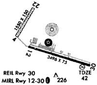
Runways
Runway Summary
| Runways: | 04/22 12/30 |
| Longest Runway: | 12/30 is 3500 ft (1067 m) long |
| Runways with an Instrument Approach: |
KTAN Airport Runway Details
| Runway 04/22 | 1900 ft x 60 ft (579 m x 18 m) | |
| Runway Length Source: | OWNER as of 01/14/2003 | |
| Surface: | Turf/Gravel - Fair condition - No special surface treatment | |
Runway 04 |
Runway 22 |
|
Elevation: |
27.0 | 27.0 |
Latitude: |
41-52-31.5570N | 41-52-48.3440N |
Longitude: |
071-01-21.7240W | 071-01-10.5040W |
|
Runway True Alignment: |
027 | 207 |
Glide Path Angle: |
0.0 degrees | 0.0 degrees |
Traffic Pattern: |
Left | Left |
Object at End: |
TREES | TREES |
Object Height: |
60 | 85 |
Distance from End: |
800 | 1000 |
Object Centerline Offset: |
125 ft. left and right of centerline | 125 ft. left of centerline |
| Runway 12/30 | 3500 ft x 75 ft (1067 m x 23 m) | |
| Runway Length Source: | 3RD PARTY SURVEY as of 05/11/2010 | |
| Surface: | Turf/Gravel - Fair condition - No special surface treatment | |
| Runway Edge Lights: | Medium Intensity | |
Runway Weight Bearing Capacity (in thousands of pounds) |
||
| Single Wheel Landing Gear: | 21.0 | |
Runway 12 |
Runway 30 |
|
Elevation: |
35.0 | 41.3 |
Latitude: |
41-52-26.8885N | 41-52-16.3914N |
Longitude: |
071-01-11.3423W | 071-00-27.2727W |
|
Runway True Alignment: |
108 | 288 |
Glide Path Angle: |
0.0 degrees | 4.0 degrees |
Traffic Pattern: |
Left | Left |
Runway Markings Type: |
Nonprecision Instrument | Nonprecision Instrument |
Runway Markings Condition: |
Good | Good |
Object at End: |
TREES | TREES |
Object Height: |
23 | 40 |
Distance from End: |
1000 | 1075 |
Object Centerline Offset: |
125 ft. left and right of centerline | 125 ft. left of centerline |
Visual Glide Slope Indicators: |
4-Light PAPI On Right Side Of Runway | |
REIL: |
Yes | |
Threshold Crossing Height: |
45 |
Services
Airframe Repair: |
Major |
Powerplant Repair: |
Major |
Bottled Oxygen: |
None |
Bulk Oxygen: |
None |
Fuel Available: |
100LL |
Landing Fees: |
No |
Parking: |
Hangars and tiedowns available |
Maps & Diagrams
KTAN Sectional
Flight Planning
at skyvector.com
at skyvector.com