Location
Latitude: |
43-27-07.9960N (43.452221) |
Longitude: |
096-10-47.1970W (-96.179777) |
Elevation: |
1363.0 feet MSL (415 m MSL) |
Magnetic Variation: |
2.2 E (as of April 2024 from WMM2020 model) |
Time Zone: |
UTC -6.0 (Standard Time) UTC -5.0 (Daylight Savings Time) |
From City: |
02 N.M. NW of Rock Rapids, Iowa |
Found On: |
Omaha Chart |
FAA Region: |
ACE |
Contacts
Manager: |
Publicly owned: |
| MICAH FREESE 411 FIRST AVENUE ROCK RAPIDS, IA 51246 712-472-4585 |
CITY OF ROCK RAPIDS 411 FIRST AVENUE ROCK RAPIDS, IA 51246 712-472-4585 |
Operations
Airport Status: |
Operational |
Facility Use: |
Public |
Type: |
Airport |
Activation Date: |
01/1961 |
Control tower: |
No |
Attendance (Months/Days/Hours): |
Months/Days/Hours ALL/MON-FRI/0900-1700 |
Boundary ARTCC: |
ZMP (Minneapolis) |
Responsible ARTCC: |
ZMP (Minneapolis) |
Lighting Schedule: |
SEE RMK |
Segmented Circle Indicator: |
No |
Traffic Pattern Altitude (MSL): |
2363 feet (720 m) |
NOTAMs Facility: |
FOD |
NOTAM-D Service: |
Yes |
International Airport of Entry: |
No |
Customs Landing Rights: |
No |
Military Landing Rights: |
Yes |
Civil/Military Joint Use: |
No |
Based Aircraft
| Single Engine: | 16 |
Annual Operations (as of 09/19/2018)
| Total Operations: | 3500 | |
| GA Local: | 1511 | 43.2% |
| GA Itinerant: | 1989 | 56.8% |
Communications
| CTAF: | 122.800 |
| Unicom: | 122.800 |
| Approach: | SIOUX FALLS 126.9 126.9 MINNEAPOLIS ARTCC |
| Departure: | SIOUX FALLS 126.9 126.9 MINNEAPOLIS ARTCC |
- APCH/DEP SVC PRVDD BY MINNEAPOLIS ARTCC ON FREQS 132.050/317.4 (SIOUX FALLS RCAG) WHEN SIOUX FALLS APCH CTL IS CLSD.
Fixed Based Operators (FBOs) & Fuel
(Click on a business for detail)
Please help us keep this information up to date. This is a FREE SERVICE just like everything else on Airport Guide! If you see that a business needs to be added, modified, or deleted please fill out our Update Form.
To add, modify, or delete a business click here.
Please help us keep this information up to date. This is a FREE SERVICE just like everything else on Airport Guide! If you see that a business needs to be added, modified, or deleted please fill out our Update Form.
Area Code: 712 |
| Business Name | Frequency | Phone | Fuel Grade |
|---|---|---|---|
| Rock Rapids Municipal
Update FBO info |
Unicom 122.8 | 472-2521 | 100LL |
Flight Service Stations
| Primary | Alternate | |
| FSS on Field: | N | |
| FSS Name (ID): | Fort Dodge(FOD) | |
| Frequency: | ||
| Toll Free Phone: | 1-800-WX-BRIEF |
Instrument Procedures / Charts
FAA Terminal Procedures valid from 0901Z 03/21/24 to 0901Z 04/18/24.
There are various types of charts available for an airport. They are listed in the Page Type column. Here is a legend for those types:
APD - Airport Diagram
DP - Departure Procedure Charts
HOT - Hot Spots
IAP - Instrument Approach Procedure Charts
MIN - Minimums
STAR - Standard Terminal Arrival Charts
| Page Type | Page Name | Volume | Action Since Last Cycle |
|---|---|---|---|
| IAP | RNAV (GPS) RWY 16 | NC-3 | |
| IAP | RNAV (GPS) RWY 34 | NC-3 | |
| MIN | TAKEOFF MINIMUMS | NC-3 |
Terminal Procedures are only available for airports in several countries with more being added all the time. If you are looking for a specific country's charts, please send an email to support(at)airportguide.com stating the country name. This will be used to prioritize the implementation.
Navigation Aids (Navaids) near KRRQ
| Dist (NM) | ID | Morse Code | Name | Type | Freq | True Hdg | Mag Hdg |
|---|---|---|---|---|---|---|---|
| 19.2 | SOY | . . . _ _ _ _ . _ _ | Sioux Center | NDB | 368 | 181 | 179 |
| 19.3 | ISB | . . . . . _ . . . | Sibley | NDB | 269 | 105 | 103 |
| 20.8 | SHL | . . . . . . . . _ . . | Sheldon | NDB | 338 | 133 | 131 |
| 28.2 | ORC | _ _ _ . _ . _ . _ . | Orange City | NDB | 521 | 169 | 167 |
| 28.4 | FS | . . _ . . . . | Rokky | NDB | 245 | 275 | 273 |
| 28.5 | OTG | _ _ _ _ _ _ . | Worthington | DME | 110.6 | 65 | 63 |
| 28.7 | FSD | . . _ . . . . _ . . | Sioux Falls | VORTAC | 115.00 | 294 | 292 |
| 32.7 | OT | _ _ _ _ | Wondd | NDB | 277 | 72 | 70 |
| 39.4 | SP | . . . . _ _ . | Snore | NDB | 394 | 109 | 107 |
| 46.1 | SPW | . . . . _ _ . . _ _ | Spencer | VOR-DME | 115.15 | 111 | 109 |
| 49.7 | LTU | . _ . . _ . . _ | Little Sioux | NDB | 326 | 112 | 110 |
| 51.8 | MDS | _ _ _ . . . . . | Wentworth | NDB | 400 | 310 | 307 |
| 53.2 | MJQ | _ _ . _ _ _ _ _ . _ | Jackson | NDB-DME | 353 | 76 | 74 |
| 53.9 | MWM | _ _ . _ _ _ _ | Windom | NDB | 203 | 59 | 57 |
| 58.0 | BKX | _ . . . _ . _ _ . . _ | Brookings | VOR-DME | 108.80 | 331 | 329 |
| 60.8 | OI | _ _ _ . . | Tommi | NDB | 305 | 191 | 189 |
| 61.2 | YK | _ . _ _ _ . _ | Cagur | NDB | 347 | 233 | 230 |
| 61.7 | YKN | _ . _ _ _ . _ _ . | Yankton | DME | 111.4 | 239 | 236 |
| 61.7 | MML | _ _ _ _ . _ . . | Marshall | VOR-DME | 111.00 | 14 | 12 |
| 62.6 | EST | . . . . _ | Estherville | VOR | 110.40 | 91 | 89 |
Nearby Airports with Fuel
Notices to Airmen (NOTAMS)
Remarks
| A110*G | THIS AIRPORT HAS BEEN SURVEYED BY THE NATIONAL GEODETIC SURVEY. |
| A110-1 | RY 34 IS CALM WIND RY. |
| A110-2 | CAUTION: MIGRATORY WATERFOWL ADJ MOVEMENT AREAS. |
| A110-3 | FOR CD CTC SIOUX FALLS APCH AT 605-336-8602, WHEN APCH CLSD CTC MINNEAPOLIS ARTCC AT 651-463-5588. |
| A17 | FOR AFTER HRS CALL (605) 988-4314. |
| A57-16 | CLNC 16:1 FROM DSPLCD THLD TO TREE. |
| A57-34 | APCH SLOPE 26:1 TO DSPLCD THLD FM 16 FT ROAD 430 FT FM DSPLCD THLD L/R. |
| A58-16 | RY 16 +15 FT ROAD 155 FT DSTC ON CNTRLN. |
| A58-34 | +16 FT ROAD 1 30 FT DSTC L/R. |
| A81-APT | ACTVT MIRL RY 16/34; PAPI RYS 16 & 34 - CTAF. |
Runways
Runway Summary
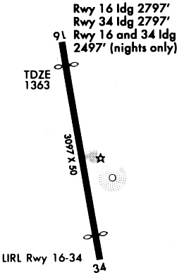
| Runways: | 16/34 |
| Longest Runway: | 16/34 is 3097 ft (944 m) long |
| Runways with an Instrument Approach: |
KRRQ Airport Runway Details
| Runway 16/34 | 3097 ft x 50 ft (944 m x 15 m) | |
| Surface: | Asphalt - Fair condition - No special surface treatment | |
| Runway Edge Lights: | Medium Intensity | |
Runway Weight Bearing Capacity (in thousands of pounds) |
||
| Single Wheel Landing Gear: | 8.0 | |
Runway 16 |
Runway 34 |
|
Elevation: |
1359.0 | 1357.0 |
Latitude: |
43-27-23.1100N | 43-26-52.8500N |
Longitude: |
096-10-50.2700W | 096-10-44.1800W |
|
Runway True Alignment: |
172 | 352 |
Glide Path Angle: |
3.0 degrees | 3.0 degrees |
Traffic Pattern: |
Left | Left |
Runway Markings Type: |
Nonprecision Instrument | Nonprecision Instrument |
Runway Markings Condition: |
Fair | Fair |
Object at End: |
TREE | |
Object Height: |
51 | |
Distance from End: |
1107 | |
Object Centerline Offset: |
284 ft. left of centerline | |
Visual Glide Slope Indicators: |
2-Light PAPI On Left Side Of Runway | 2-Light PAPI On Left Side Of Runway |
Threshold Crossing Height: |
28 | 29 |
Threshold Elevation: |
1359.0 | 1357.0 |
Displaced Threshold: |
300 | 300 |
Threshold Latitude: |
43-27-20.1800N | 43-26-55.7800N |
Threshold Longitude: |
096-10-49.6800W | 096-10-44.7700W |
Services
Airframe Repair: |
Major |
Powerplant Repair: |
Major |
Bottled Oxygen: |
None |
Bulk Oxygen: |
None |
Fuel Available: |
100, Jet A |
Landing Fees: |
No |
Parking: |
Hangars and tiedowns available |
Maps & Diagrams
KRRQ Sectional
Flight Planning
at skyvector.com
at skyvector.com