Location
Latitude: |
32-57-58.9490N (32.966375) |
Longitude: |
082-50-14.9590W (-82.837489) |
Elevation: |
438.5 feet MSL (134 m MSL) |
Magnetic Variation: |
6.4 W (as of April 2024 from WMM2020 model) |
Time Zone: |
UTC -5.0 (Standard Time) UTC -4.0 (Daylight Savings Time) |
From City: |
02 N.M. SW of Sandersville, Georgia |
Found On: |
Atlanta Chart |
FAA Region: |
ASO |
Contacts
Manager: |
Publicly owned: |
| RAY LAWRENCE 1726 KAOLIN RD SANDERSVILLE, GA 31082 478-552-9136 |
WASHINGTON CO PO BOX 271 SANDERSVILLE, GA 31082 478-552-9136 |
Operations
Airport Status: |
Operational |
Facility Use: |
Public |
Type: |
Airport |
Control tower: |
No |
Attendance (Months/Days/Hours): |
Months/Days/Hours ALL/MON-FRI/0800-1700 |
Boundary ARTCC: |
ZTL (Atlanta) |
Responsible ARTCC: |
ZTL (Atlanta) |
Lighting Schedule: |
SEE RMK |
Segmented Circle Indicator: |
Yes |
Traffic Pattern Altitude (MSL): |
1438 feet (438 m) |
NOTAMs Facility: |
MCN |
NOTAM-D Service: |
Yes |
International Airport of Entry: |
No |
Customs Landing Rights: |
No |
Military Landing Rights: |
Yes |
Civil/Military Joint Use: |
No |
Based Aircraft
| Single Engine: | 26 |
Annual Operations (as of 12/31/2022)
| Total Operations: | 10150 | |
| GA Local: | 5000 | 49.3% |
| GA Itinerant: | 5000 | 49.3% |
| Military Aircraft: | 150 | 1.5% |
Communications
| CTAF: | 123.000 |
| Unicom: | 123.000 |
| Approach: | ATLANTA 124.2 124.2 124.2 ATLANTA ARTCC |
| Departure: | ATLANTA 124.2 124.2 124.2 ATLANTA ARTCC |
| AWOS-3: | 120.575 (478-240-9432) |
- ATLANTA LARGE TRACON PROVIDES APCH/DEP SVC 0615-2300 ON FREQ 124.2; ATLANTA ARTCC PROVIDES APCH/DEP SVC 2300-0615 ON FREQS 123.95/269.3 (MACON RCAG).
Fixed Based Operators (FBOs) & Fuel
(Click on a business for detail)
Please help us keep this information up to date. This is a FREE SERVICE just like everything else on Airport Guide! If you see that a business needs to be added, modified, or deleted please fill out our Update Form.
To add, modify, or delete a business click here.
Please help us keep this information up to date. This is a FREE SERVICE just like everything else on Airport Guide! If you see that a business needs to be added, modified, or deleted please fill out our Update Form.
Area Code: 912 |
| Business Name | Frequency | Phone | Fuel Grade |
|---|
Flight Service Stations
| Primary | Alternate | |
| FSS on Field: | N | |
| FSS Name (ID): | Macon(MCN) | |
| Frequency: | ||
| Toll Free Phone: | 1-800-WX-BRIEF |
Instrument Procedures / Charts
FAA Terminal Procedures valid from 0901Z 03/21/24 to 0901Z 04/18/24.
There are various types of charts available for an airport. They are listed in the Page Type column. Here is a legend for those types:
APD - Airport Diagram
DP - Departure Procedure Charts
HOT - Hot Spots
IAP - Instrument Approach Procedure Charts
MIN - Minimums
STAR - Standard Terminal Arrival Charts
| Page Type | Page Name | Volume | Action Since Last Cycle |
|---|---|---|---|
| IAP | RNAV (GPS) RWY 13 | SE-4 | |
| IAP | RNAV (GPS) RWY 31 | SE-4 | |
| MIN | ALTERNATE MINIMUMS | SE-4 | |
| MIN | TAKEOFF MINIMUMS | SE-4 |
Terminal Procedures are only available for airports in several countries with more being added all the time. If you are looking for a specific country's charts, please send an email to support(at)airportguide.com stating the country name. This will be used to prioritize the implementation.
Navigation Aids (Navaids) near KOKZ
| Dist (NM) | ID | Morse Code | Name | Type | Freq | True Hdg | Mag Hdg |
|---|---|---|---|---|---|---|---|
| 6.0 | HIT | . . . . . . _ | Kaolin | NDB | 360 | 300 | 306 |
| 19.7 | UMB | . . _ _ _ _ . . . | Culvr | NDB | 380 | 304 | 310 |
| 24.2 | DBN | _ . . _ . . . _ . | Dublin | VORTAC | 113.10 | 179 | 185 |
| 26.5 | EEX | . . _ . . _ | Emanuel County | NDB | 309 | 132 | 139 |
| 30.2 | DB | _ . . _ . . . | Creke | NDB | 251 | 196 | 202 |
| 35.8 | AA | . _ . _ | Cedar | NDB | 341 | 18 | 25 |
| 41.8 | VV | . . . _ . . . _ | Junne | NDB | 353 | 347 | 353 |
| 42.7 | WRB | . _ _ . _ . _ . . . | Robins | TACAN | 135.30 | 243 | 249 |
| 44.0 | MCN | _ _ _ . _ . _ . | Macon | DME | 114.2 | 248 | 254 |
| 44.1 | LNH | . _ . . _ . . . . . | Millen | NDB | 205 | 95 | 102 |
| 48.5 | IIY | . . . . _ . _ _ | Washington/Wilkes County | NDB | 435 | 1 | 7 |
| 48.7 | AG | . _ _ _ . | Bushe | NDB | 233 | 66 | 73 |
| 51.6 | EMR | . _ _ . _ . | Emory | NDB | 385 | 54 | 61 |
| 52.3 | UQN | . . _ _ _ . _ _ . | Onyun | NDB | 372 | 148 | 155 |
| 52.3 | MQW | _ _ _ _ . _ . _ _ | Mc Rae | NDB | 280 | 182 | 188 |
| 52.6 | EZM | . _ _ . . _ _ | Eastman | NDB | 366 | 197 | 203 |
| 55.9 | IRQ | . . . _ . _ _ . _ | Colliers | VORTAC | 113.90 | 37 | 44 |
| 55.9 | BEP | _ . . . . . _ _ . | Bay Creek | NDB | 350 | 237 | 243 |
| 56.2 | VNA | . . . _ _ . . _ | Vienna | VORTAC | 116.50 | 216 | 222 |
| 61.9 | VOF | . . . _ _ _ _ . . _ . | Alcovy | NDB | 370 | 310 | 316 |
Nearby Airports with Fuel
Notices to Airmen (NOTAMS)
Remarks
| A11 | AND CITY OF SANDERSVILLE |
| A110-1 | DEER ON & INVOF RYS & TWYS. |
| A110-2 | FOR CD CTC ATLANTA APCH AT 678-364-6132, WHEN APCH CLSD CTC ATLANTA ARTCC AT 770-210-7692. |
| A57-13 | CONTROLLING OBSTRUCTION EXCEEDS A 45 DEGREE SLOPE |
| A58-13 | TREES 380' L AND 480' R FROM EOR TO 200' FROM EOR |
| A58-31 | TREES AS CLOSE AS 285' RIGHT, ROAD 365' LEFT FROM EOR TO 200' FROM EOR |
| A81-APT | REIL RWY 13; MIRL RWY 13/31 PRESET LOW INTST DUSK-2200; TO INCR INTST & ACTVT AFT 2200 - CTAF. ACTVT PAPI RWYS 13 & 31 - CTAF. |
Runways
Runway Summary
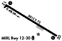
| Runways: | 13/31 |
| Longest Runway: | 13/31 is 5501 ft (1677 m) long |
| Runways with an Instrument Approach: |
KOKZ Airport Runway Details
| Runway 13/31 | 5501 ft x 75 ft (1677 m x 23 m) | |
| Runway Length Source: | 3RD PARTY SURVEY as of 02/05/2020 | |
| Surface: | Asphalt - Good condition - No special surface treatment | |
| Runway Edge Lights: | Medium Intensity | |
Runway Weight Bearing Capacity (in thousands of pounds) |
||
| Single Wheel Landing Gear: | 17.0 | |
Runway 13 |
Runway 31 |
|
Elevation: |
407.1 | 435.2 |
Latitude: |
32-58-12.7378N | 32-57-45.1583N |
Longitude: |
082-50-42.7883W | 082-49-47.1328W |
|
Runway True Alignment: |
120 | 300 |
Glide Path Angle: |
3.0 degrees | 3.6 degrees |
Traffic Pattern: |
Left | Left |
Runway Markings Type: |
Nonprecision Instrument | Nonprecision Instrument |
Runway Markings Condition: |
Good | Good |
Object at End: |
TREES | TREES |
Object Height: |
30 | 30 |
Distance from End: |
201 | 201 |
Object Centerline Offset: |
380 ft. left of centerline | 340 ft. right of centerline |
Visual Glide Slope Indicators: |
2-Light PAPI On Left Side Of Runway | 2-Light PAPI On Left Side Of Runway |
REIL: |
Yes | No |
Threshold Crossing Height: |
38 | 41 |
Threshold Elevation: |
436.7 | |
Displaced Threshold: |
486 | |
Threshold Latitude: |
32-57-47.5975N | |
Threshold Longitude: |
082-49-52.0531W | |
Declared Distances |
||
Take Off Run Avbl. (TORA): |
5501 | 5501 |
Take Off Distance Avbl. (TODA): |
5501 | 5501 |
Actual Stop Dist. Avbl. (ASDA): |
5501 | 5501 |
Landing Dist. Avbl. (LDA): |
5501 | 5015 |
Services
Airframe Repair: |
None |
Powerplant Repair: |
None |
Bottled Oxygen: |
None |
Bulk Oxygen: |
None |
Fuel Available: |
100LL |
Landing Fees: |
No |
Parking: |
Tiedowns available |
Maps & Diagrams
KOKZ Sectional
Flight Planning
at skyvector.com
at skyvector.com