Location
Latitude: |
39-06-42.3000N (39.11175) |
Longitude: |
100-49-00.3000W (-100.81675) |
Elevation: |
3045.2 feet MSL (928 m MSL) |
Magnetic Variation: |
5.3 E (as of April 2024 from WMM2020 model) |
Time Zone: |
UTC -6.0 (Standard Time) UTC -5.0 (Daylight Savings Time) |
From City: |
02 N.M. SE of Oakley, Kansas |
Found On: |
Wichita Chart |
FAA Region: |
ACE |
Contacts
Manager: |
Publicly owned: |
| JOHN HOLZMEISTER CITY HALL, 209 HUDSON AVE OAKLEY, KS 67748-6016 785-672-0147 |
CITY OF OAKLEY CITY HALL, 209 HUDSON AVE OAKLEY, KS 67748 785-671-3136 |
Operations
Airport Status: |
Operational |
Facility Use: |
Public |
Type: |
Airport |
Activation Date: |
10/1953 |
Control tower: |
No |
Attendance (Months/Days/Hours): |
Months/Days/Hours ALL/MON-FRI/0800-1700 |
Boundary ARTCC: |
ZDV (Denver) |
Responsible ARTCC: |
ZDV (Denver) |
Lighting Schedule: |
SEE RMK |
Segmented Circle Indicator: |
Yes |
Traffic Pattern Altitude (MSL): |
4045 feet (1233 m) |
NOTAMs Facility: |
ICT |
NOTAM-D Service: |
Yes |
International Airport of Entry: |
No |
Customs Landing Rights: |
No |
Military Landing Rights: |
Yes |
Civil/Military Joint Use: |
No |
Based Aircraft
| Single Engine: | 10 |
Annual Operations (as of 09/16/2022)
| Total Operations: | 12100 | |
| GA Local: | 7000 | 57.9% |
| GA Itinerant: | 5100 | 42.1% |
Communications
| CTAF: | 122.800 |
| Unicom: | 122.800 |
| AWOS-3: | 118.325 (785-671-4194) |
- APCH/DEP CTL SVC PRVDD BY DENVER ARTCC (ZDV) ON FREQS 132.7/226.675 (GOODLAND RCAG).
Fixed Based Operators (FBOs) & Fuel
(Click on a business for detail)
Please help us keep this information up to date. This is a FREE SERVICE just like everything else on Airport Guide! If you see that a business needs to be added, modified, or deleted please fill out our Update Form.
To add, modify, or delete a business click here.
Please help us keep this information up to date. This is a FREE SERVICE just like everything else on Airport Guide! If you see that a business needs to be added, modified, or deleted please fill out our Update Form.
Area Code: 785 |
| Business Name | Frequency | Phone | Fuel Grade |
|---|---|---|---|
| Hawk's Nest Aircraft Service
Update FBO info |
672-4621 | 100LL |
Flight Service Stations
| Primary | Alternate | |
| FSS on Field: | N | |
| FSS Name (ID): | Wichita(ICT) | |
| Frequency: | ||
| Toll Free Phone: | 1-800-WX-BRIEF |
Instrument Procedures / Charts
FAA Terminal Procedures valid from 0901Z 03/21/24 to 0901Z 04/18/24.
There are various types of charts available for an airport. They are listed in the Page Type column. Here is a legend for those types:
APD - Airport Diagram
DP - Departure Procedure Charts
HOT - Hot Spots
IAP - Instrument Approach Procedure Charts
MIN - Minimums
STAR - Standard Terminal Arrival Charts
| Page Type | Page Name | Volume | Action Since Last Cycle |
|---|---|---|---|
| IAP | RNAV (GPS) RWY 34 | NC-2 | |
| MIN | ALTERNATE MINIMUMS | NC-2 | |
| MIN | TAKEOFF MINIMUMS | NC-2 |
Terminal Procedures are only available for airports in several countries with more being added all the time. If you are looking for a specific country's charts, please send an email to support(at)airportguide.com stating the country name. This will be used to prioritize the implementation.
Navigation Aids (Navaids) near KOEL
| Dist (NM) | ID | Morse Code | Name | Type | Freq | True Hdg | Mag Hdg |
|---|---|---|---|---|---|---|---|
| 0.1 | OEL | _ _ _ . . _ . . | Oakley | NDB | 380 | 56 | 51 |
| 26.2 | JDM | . _ _ _ _ . . _ _ | Wheatfield | NDB | 408 | 335 | 330 |
| 28.9 | HLC | . . . . . _ . . _ . _ . | Hill City | VORTAC | 113.70 | 72 | 67 |
| 38.0 | GL | _ _ . . _ . . | Shugr | NDB | 414 | 286 | 281 |
| 38.0 | TQK | _ _ _ . _ _ . _ | Scott City | NDB | 256 | 185 | 180 |
| 43.9 | GLD | _ _ . . _ . . _ . . | Goodland | VORTAC | 115.10 | 292 | 286 |
| 45.0 | OIN | _ _ _ . . _ . | Oberlin | NDB | 341 | 16 | 11 |
| 57.5 | SYF | . . . _ . _ _ . . _ . | St Francis | NDB | 386 | 310 | 304 |
| 61.9 | NRN | _ . . _ . _ . | Norton | NDB | 230 | 43 | 38 |
| 65.3 | MCK | _ _ _ . _ . _ . _ | Mc Cook | FAN MARKER | 11 | 6 | |
| 66.3 | MCK | _ _ _ . _ . _ . _ | Mc Cook | VOR-DME | 115.30 | 8 | 3 |
| 68.7 | ITR | . . _ . _ . | Kit Carson | NDB | 209 | 277 | 271 |
| 71.7 | GCK | _ _ . _ . _ . _ . _ | Garden City | VORTAC | 113.30 | 176 | 171 |
| 73.6 | HYS | . . . . _ . _ _ . . . | Hays | VORTAC | 110.40 | 101 | 96 |
| 75.9 | HY | . . . . _ . _ _ | Nette | NDB | 374 | 105 | 100 |
| 77.1 | GC | _ _ . _ . _ . | Pieve | NDB | 347 | 176 | 171 |
| 77.8 | CSB | _ . _ . . . . _ . . . | Harry Strunk | NDB | 389 | 22 | 17 |
| 79.3 | PHG | . _ _ . . . . . _ _ . | Phillipsburg | NDB | 368 | 62 | 57 |
| 80.7 | HCT | . . . . _ . _ . _ | Hayes Center | VORTAC | 117.70 | 356 | 351 |
| 84.7 | DDC | _ . . _ . . _ . _ . | Dodge City | VORTAC | 108.20 | 153 | 148 |
Nearby Airports with Fuel
Notices to Airmen (NOTAMS)
Remarks
| A110-1 | PUBLIC PHONE AVBL. |
| A110-2 | SELF SVC FUEL AVBL 24 HRS WITH CREDIT CARD. |
| A110-3 | FOR SVC AFTER HRS CALL 785-672-0147. |
| A110-4 | FOR CD CTC DENVER ARTCC AT 303-651-4257. |
| A16 | JHOLZMEISTER@FRONTIERAGINC.COM |
| A43-16 | PAPI UNUSBL BYD 8 DEG RIGHT AND 6 DEG LEFT OF CNTRLN. |
| A43-34 | PAPI UNUSBL BYD 8 DEG LEFT OF CNTRLN. |
| A52-08 | C.PIVOT 63 FT HD CNTR OFF RWY. |
| A81-APT | PAPI RWY 16/34 - CTAF. DUSK-2230. MIRL RWY 16/34 PRESET LOW INTST DUSK-2230; TO INCR INTST - CTAF; AFTER 2230 ACTVT MIRL RWY 16/34 - CTAF. |
Runways
Runway Summary
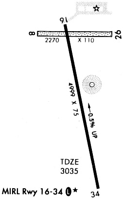
| Runways: | 08/26 16/34 |
| Longest Runway: | 16/34 is 5000 ft (1524 m) long |
| Runways with an Instrument Approach: |
KOEL Airport Runway Details
| Runway 08/26 | 2153 ft x 110 ft (656 m x 34 m) | |
| Runway Length Source: | 3RD PARTY SURVEY as of 02/06/2017 | |
| Surface: | Turf - Good condition - No special surface treatment | |
Runway 08 |
Runway 26 |
|
Elevation: |
3042.0 | 3039.9 |
Latitude: |
39-06-57.6663N | 39-06-57.1451N |
Longitude: |
100-49-16.7082W | 100-48-49.4042W |
|
Runway True Alignment: |
091 | 271 |
Glide Path Angle: |
0.0 degrees | 0.0 degrees |
Traffic Pattern: |
Left | Left |
Runway Markings Type: |
None | None |
Runway Markings Condition: |
Fair | Fair |
Object at End: |
OTHER | ROAD |
Object Height: |
25 | 17 |
Distance from End: |
63 | 255 |
Object Centerline Offset: |
0 ft. left and right of centerline | 0 ft. left and right of centerline |
| Runway 16/34 | 5000 ft x 75 ft (1524 m x 23 m) | |
| Runway Length Source: | 3RD PARTY SURVEY as of 02/06/2017 | |
| Surface: | Turf - Good condition - No special surface treatment | |
| Runway Edge Lights: | Medium Intensity | |
Runway Weight Bearing Capacity (in thousands of pounds) |
||
| Single Wheel Landing Gear: | 30.0 | |
Runway 16 |
Runway 34 |
|
Elevation: |
3045.2 | 3020.3 |
Latitude: |
39-07-00.0519N | 39-06-11.5590N |
Longitude: |
100-49-05.2391W | 100-48-53.0671W |
|
Runway True Alignment: |
169 | 349 |
Glide Path Angle: |
3.0 degrees | 3.0 degrees |
Runway Markings Type: |
Nonprecision Instrument | Nonprecision Instrument |
Runway Markings Condition: |
Good | Good |
Object at End: |
BLDG | TREE |
Object Height: |
30 | 25 |
Distance from End: |
740 | 260 |
Object Centerline Offset: |
0 ft. left and right of centerline | 0 ft. left and right of centerline |
Visual Glide Slope Indicators: |
2-Light PAPI On Left Side Of Runway | 2-Light PAPI On Left Side Of Runway |
REIL: |
Yes | Yes |
Threshold Crossing Height: |
44 | 44 |
Declared Distances |
||
Take Off Run Avbl. (TORA): |
5000 | 5000 |
Take Off Distance Avbl. (TODA): |
5000 | 5000 |
Actual Stop Dist. Avbl. (ASDA): |
5000 | 5000 |
Landing Dist. Avbl. (LDA): |
5000 | 5000 |
Services
Airframe Repair: |
Major |
Powerplant Repair: |
Major |
Fuel Available: |
100LL |
Landing Fees: |
No |
Parking: |
Hangars and tiedowns available |
Maps & Diagrams
KOEL Sectional
Flight Planning
at skyvector.com
at skyvector.com