Location
Latitude: |
46-07-04.8000N (46.118) |
Longitude: |
122-53-54.1000W (-122.898361) |
Elevation: |
20.1 feet MSL (6 m MSL) |
Magnetic Variation: |
15 E (as of April 2024 from WMM2020 model) |
Time Zone: |
UTC -8.0 (Standard Time) UTC -7.0 (Daylight Savings Time) |
From City: |
02 N.M. SE of Kelso, Washington |
Found On: |
Seattle Chart |
FAA Region: |
ANM |
Contacts
Manager: |
Publicly owned: |
| CHRISTOPHER PAOLINI POB 819 KELSO, WA 98626 360-261-8268 |
CITY OF KELSO 203 S. PACIFIC AVE , PO BOX 819 KELSO, WA 98626 360-577-3370 |
Operations
Airport Status: |
Operational |
Facility Use: |
Public |
Type: |
Airport |
Activation Date: |
05/1941 |
Control tower: |
No |
Attendance (Months/Days/Hours): |
Months/Days/Hours ALL/ALL/0800-1700 |
Boundary ARTCC: |
ZSE (Seattle) |
Responsible ARTCC: |
ZSE (Seattle) |
Lighting Schedule: |
SEE RMK |
Segmented Circle Indicator: |
Yes |
Traffic Pattern Altitude (MSL): |
1020 feet (311 m) |
NOTAMs Facility: |
KLS |
NOTAM-D Service: |
Yes |
International Airport of Entry: |
No |
Customs Landing Rights: |
No |
Military Landing Rights: |
Yes |
Civil/Military Joint Use: |
No |
Based Aircraft
| Single Engine: | 51 |
| Multi Engine: | 6 |
| Jet Engine: | 1 |
| GA Helicopters: | 1 |
Annual Operations (as of 12/31/2020)
| Total Operations: | 40860 | |
| Air Taxi: | 1675 | 4.1% |
| GA Local: | 19700 | 48.2% |
| GA Itinerant: | 18800 | 46.0% |
| Military Aircraft: | 685 | 1.7% |
Communications
| CTAF: | 122.725 |
| Unicom: | 122.725 |
| AWOS-3PT: | 135.075 (360-577-1964) |
- APCH/DEP CTL SVC PRVDD BY SEATTLE ARTCC (ZSE) ON FREQS 124.2/317.6 (SCAPPOOSE RCAG).
- COMMUNICATIONS PRVDD BY SEATTLE RADIO ON FREQ 122.25 (SOUTHWEST WASHINGTON RCO).
Fixed Based Operators (FBOs) & Fuel
(Click on a business for detail)
Please help us keep this information up to date. This is a FREE SERVICE just like everything else on Airport Guide! If you see that a business needs to be added, modified, or deleted please fill out our Update Form.
To add, modify, or delete a business click here.
Please help us keep this information up to date. This is a FREE SERVICE just like everything else on Airport Guide! If you see that a business needs to be added, modified, or deleted please fill out our Update Form.
Area Code: 360 |
| Business Name | Frequency | Phone | Fuel Grade |
|---|---|---|---|
| Aircraft Interior Technologies
Update FBO info |
575-9253 | ||
| Custom Aircraft Painting
Update FBO info |
636-5000 | ||
| Kelso Flight Service, Inc.
Update FBO info |
Unicom 122.8 | 414-5960 | 100ll, Jet A |
| Northwest Air Tech
Update FBO info |
501-4631 |
Flight Service Stations
| Primary | Alternate | |
| FSS on Field: | N | |
| FSS Name (ID): | Seattle(SEA) | |
| Frequency: | ||
| Toll Free Phone: | 1-800-WX-BRIEF |
Instrument Procedures / Charts
FAA Terminal Procedures valid from 0901Z 03/21/24 to 0901Z 04/18/24.
There are various types of charts available for an airport. They are listed in the Page Type column. Here is a legend for those types:
APD - Airport Diagram
DP - Departure Procedure Charts
HOT - Hot Spots
IAP - Instrument Approach Procedure Charts
MIN - Minimums
STAR - Standard Terminal Arrival Charts
| Page Type | Page Name | Volume | Action Since Last Cycle |
|---|---|---|---|
| IAP | RNAV (GPS) RWY 12 | NW-1 | |
| MIN | ALTERNATE MINIMUMS | NW-1 | |
| MIN | TAKEOFF MINIMUMS | NW-1 | |
| ODP | KELSO TWO (OBSTACLE) (RNAV) | NW-1 |
Terminal Procedures are only available for airports in several countries with more being added all the time. If you are looking for a specific country's charts, please send an email to support(at)airportguide.com stating the country name. This will be used to prioritize the implementation.
Navigation Aids (Navaids) near KLS
| Dist (NM) | ID | Morse Code | Name | Type | Freq | True Hdg | Mag Hdg |
|---|---|---|---|---|---|---|---|
| 2.3 | LSO | . _ . . . . . _ _ _ | Kelso | NDB | 256 | 345 | 330 |
| 25.6 | BTG | _ . . . _ _ _ . | Battle Ground | VORTAC | 116.60 | 149 | 134 |
| 28.7 | PEN | . _ _ . . _ . | Karpen | NDB | 201 | 272 | 257 |
| 29.9 | PND | . _ _ . _ . _ . . | Banks | NDB | 356 | 191 | 176 |
| 33.6 | PDX | . _ _ . _ . . _ . . _ | Portland | VOT | 111.00 | 158 | 143 |
| 33.7 | PDX | . _ _ . _ . . _ . . _ | Portland | VOR-DME | 111.80 | 158 | 143 |
| 34.0 | CBU | _ . _ . _ . . . . . _ | Columbia | TACAN | 109.20 | 159 | 144 |
| 34.7 | HIO | . . . . . . _ _ _ | Hillsboro | VOT | 115.20 | 183 | 168 |
| 39.1 | LBH | . _ . . _ . . . . . . . | Laker | NDB | 332 | 152 | 137 |
| 40.9 | AST | . _ . . . _ | Astoria | VOR-DME | 114.00 | 274 | 259 |
| 44.7 | AST | . _ . . . _ | Fort Stevens | FAN MARKER | 277 | 262 | |
| 46.0 | UBG | . . _ _ . . . _ _ . | Newberg | VOR-DME | 117.40 | 184 | 169 |
| 51.2 | OLM | _ _ _ . _ . . _ _ | Olympia | VORTAC | 113.40 | 359 | 344 |
| 55.2 | LAC | . _ . . . _ _ . _ . | Lacomas | NDB | 328 | 14 | 359 |
| 63.1 | GRF | _ _ . . _ . . . _ . | Graye | NDB | 216 | 10 | 355 |
| 64.2 | TCM | _ _ . _ . _ _ | Mcchord | TACAN | 109.60 | 15 | 360 |
| 68.2 | MNC | _ _ _ . _ . _ . | Mason County | NDB | 348 | 353 | 338 |
| 71.7 | HQM | . . . . _ _ . _ _ _ | Hoquiam | VORTAC | 117.70 | 314 | 299 |
| 76.3 | SL | . . . . _ . . | Turno | NDB | 266 | 181 | 166 |
| 77.6 | CAN | _ . _ . . _ _ . | Carney | NDB | 274 | 1 | 346 |
Nearby Airports with Fuel
Notices to Airmen (NOTAMS)
Remarks
| A110-1 | NMRS FLOCKS OF BIRDS ON & INVOF ARPT. |
| A110-2 | NO FLD COND NOTAMS AVBL M-F 1700-0800 AND ALL DAY SAT AND SUN. |
| A110-3 | FOR CD IF UNA TO CTC ON FSS FREQ, CTC SEATTLE ARTCC AT 253-351-3694. |
| A15 | ARPT OFC ADS (NOT FOR MAILING): 2215 B PARROTT WAY, KELSO, WA 98626 |
| A40-12/30 | RY 12/30 MIRL NSTD SPACING. |
| A58-30 | +3' HILL FROM 40' TO 200'; 105L. |
| A70-FUEL-10 | 0LL 24 HR SELF SVC CREDIT CARD FUEL FAC 100LL. AFT HRS JET-A SVC CALL-OUT AVBL. |
| A75 | PILOTS BRING OWN TIEDOWNS. |
| A81-APT | ACTVT REIL RWY 12 & 30; PAPI RWY 12 & 30; MIRL RWY 12/30 - CTAF. |
| A83 | MIDFIELD, OTS INDEFLY. |
| E111 | ESTABD PRIOR TO 15 MAY 1959. |
| E80 | FLIGHT NOTIFICATION SERVICE (ADCUS) AVBL. |
Runways
Runway Summary
| Runways: | 12/30 |
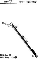
| Longest Runway: | 12/30 is 4391 ft (1338 m) long |
| Runways with an Instrument Approach: |
KLS Airport Runway Details
| Runway 12/30 | 4391 ft x 100 ft (1338 m x 30 m) | |
| Runway Length Source: | 3RD PARTY SURVEY as of 08/26/2017 | |
| Surface: | Asphalt - Good condition - No special surface treatment | |
| Runway Edge Lights: | Medium Intensity | |
Runway Weight Bearing Capacity (in thousands of pounds) |
||
| Single Wheel Landing Gear: | 38.0 | |
| Dual Wheel Landing Gear: | 46.0 | |
| Dual Tandem Wheel Landing Gear: | 74.0 | |
Runway 12 |
Runway 30 |
|
Elevation: |
20.0 | 15.9 |
Latitude: |
46-07-21.5267N | 46-06-48.1517N |
Longitude: |
122-54-14.0234W | 122-53-34.2528W |
|
Runway True Alignment: |
140 | 320 |
Glide Path Angle: |
4.0 degrees | 4.0 degrees |
Traffic Pattern: |
Right | Left |
Runway Markings Type: |
Nonprecision Instrument | Nonprecision Instrument |
Runway Markings Condition: |
Good | Good |
Object at End: |
TREES | TREES |
Object Height: |
45 | 31 |
Distance from End: |
1300 | 900 |
Object Centerline Offset: |
110 ft. left of centerline | 0 ft. left and right of centerline |
Visual Glide Slope Indicators: |
4-Light PAPI On Right Side Of Runway | 4-Light PAPI On Left Side Of Runway |
REIL: |
Yes | Yes |
Threshold Crossing Height: |
65 | 62 |
Services
Airframe Repair: |
None |
Powerplant Repair: |
None |
Bottled Oxygen: |
None |
Bulk Oxygen: |
None |
Fuel Available: |
100LL, Jet A |
Landing Fees: |
No |
Parking: |
Tiedowns available |
Maps & Diagrams
KLS Sectional
Flight Planning
at skyvector.com
at skyvector.com