Location
Latitude: |
31-03-24.8000N (31.056889) |
Longitude: |
082-46-31.0000W (-82.775278) |
Elevation: |
186.7 feet MSL (57 m MSL) |
Magnetic Variation: |
6.2 W (as of April 2024 from WMM2020 model) |
Time Zone: |
UTC -5.0 (Standard Time) UTC -4.0 (Daylight Savings Time) |
From City: |
02 N.M. NW of Homerville, Georgia |
Found On: |
Jacksonville Chart |
FAA Region: |
ASO |
Contacts
Manager: |
Publicly owned: |
| WALLACE MINCEY PO BOX 535 HOMERVILLE, GA 31634 912-487-2375 |
CITY OF HOMERVILLE PO BOX 535 HOMERVILLE, GA 31634 912-487-2375 |
Operations
Airport Status: |
Operational |
Facility Use: |
Public |
Type: |
Airport |
Activation Date: |
07/1944 |
Control tower: |
No |
Attendance (Months/Days/Hours): |
Months/Days/Hours Unattended |
Boundary ARTCC: |
ZJX (Jacksonville) |
Responsible ARTCC: |
ZJX (Jacksonville) |
Lighting Schedule: |
SEE RMK |
Segmented Circle Indicator: |
Yes |
Traffic Pattern Altitude (MSL): |
1187 feet (362 m) |
NOTAMs Facility: |
MCN |
NOTAM-D Service: |
Yes |
International Airport of Entry: |
No |
Customs Landing Rights: |
No |
Military Landing Rights: |
Yes |
Civil/Military Joint Use: |
No |
Based Aircraft
| Single Engine: | 1 |
Annual Operations (as of 12/31/2021)
| Total Operations: | 1800 | |
| GA Local: | 1000 | 55.6% |
| GA Itinerant: | 800 | 44.4% |
Communications
| CTAF: | 122.900 |
| Approach: | VALDOSTA 126.6 ;EAST OF VAD 360-VAD 180 126.6 ;EAST OF VAD 360-VAD 180 126.6 ;EAST OF VAD 360-VAD 180 JAX ARTCC |
| Departure: | VALDOSTA 126.6 ;EAST OF VAD 360-VAD 180 126.6 ;EAST OF VAD 360-VAD 180 126.6 ;EAST OF VAD 360-VAD 180 JAX ARTCC |
| AWOS-3: | 118.725 (912-487-1253) |
- APCH/DEP SVC PRVDD BY JACKSONVILLE ARTCC ON FREQS 133.7/323.3(VALDOSTA RCAG) WHEN VALDOSTA APCH CTL CLSD.
Fixed Based Operators (FBOs) & Fuel
(Click on a business for detail)
Please help us keep this information up to date. This is a FREE SERVICE just like everything else on Airport Guide! If you see that a business needs to be added, modified, or deleted please fill out our Update Form.
To add, modify, or delete a business click here.
Please help us keep this information up to date. This is a FREE SERVICE just like everything else on Airport Guide! If you see that a business needs to be added, modified, or deleted please fill out our Update Form.
Area Code: 912 |
| Business Name | Frequency | Phone | Fuel Grade |
|---|
Flight Service Stations
| Primary | Alternate | |
| FSS on Field: | N | |
| FSS Name (ID): | Macon(MCN) | |
| Frequency: | ||
| Toll Free Phone: | 1-800-WX-BRIEF |
Instrument Procedures / Charts
FAA Terminal Procedures valid from 0901Z 03/21/24 to 0901Z 04/18/24.
There are various types of charts available for an airport. They are listed in the Page Type column. Here is a legend for those types:
APD - Airport Diagram
DP - Departure Procedure Charts
HOT - Hot Spots
IAP - Instrument Approach Procedure Charts
MIN - Minimums
STAR - Standard Terminal Arrival Charts
| Page Type | Page Name | Volume | Action Since Last Cycle |
|---|---|---|---|
| IAP | NDB RWY 14 | SE-4 | |
| IAP | RNAV (GPS) RWY 14 | SE-4 | |
| IAP | RNAV (GPS) RWY 32 | SE-4 | |
| IAP | VOR/DME-A | SE-4 | |
| MIN | ALTERNATE MINIMUMS | SE-4 | |
| MIN | TAKEOFF MINIMUMS | SE-4 |
Terminal Procedures are only available for airports in several countries with more being added all the time. If you are looking for a specific country's charts, please send an email to support(at)airportguide.com stating the country name. This will be used to prioritize the implementation.
Navigation Aids (Navaids) near KHOE
| Dist (NM) | ID | Morse Code | Name | Type | Freq | True Hdg | Mag Hdg |
|---|---|---|---|---|---|---|---|
| 0.2 | HOE | . . . . _ _ _ . | Homerville | NDB | 209 | 115 | 121 |
| 17.0 | AYS | . _ _ . _ _ . . . | Waycross | VORTAC | 110.20 | 41 | 47 |
| 22.2 | OWC | _ _ _ . _ _ _ . _ . | Coffee County | NDB | 390 | 339 | 345 |
| 22.3 | VAD | . . . _ . _ _ . . | Moody | TACAN | 113.30 | 254 | 260 |
| 25.2 | AY | . _ _ . _ _ | Wiket | NDB | 219 | 50 | 56 |
| 30.8 | OTK | _ _ _ _ _ . _ | Valdosta | VOR-DME | 114.80 | 237 | 243 |
| 31.9 | AMG | . _ _ _ _ _ . | Alma | VORTAC | 115.10 | 25 | 31 |
| 35.1 | TAY | _ . _ _ . _ _ | Taylor | VORTAC | 112.90 | 160 | 166 |
| 38.9 | TM | _ _ _ | Tifto | NDB | 409 | 298 | 304 |
| 42.6 | SUR | . . . . . _ . _ . | Fitzgerald | NDB | 362 | 321 | 327 |
| 42.9 | IFM | . . . . _ . _ _ | Tift Myers | VOR | 112.50 | 301 | 307 |
| 44.0 | BHC | _ . . . . . . . _ . _ . | Baxley | NDB | 376 | 26 | 32 |
| 49.8 | AZE | . _ _ _ . . . | Hazlehurst | NDB | 414 | 7 | 13 |
| 52.9 | MGR | _ _ _ _ . . _ . | Moultrie | DME | 108.8 | 271 | 277 |
| 53.3 | LCQ | . _ . . _ . _ . _ _ . _ | Lake City | NDB | 204 | 168 | 174 |
| 54.4 | JES | . _ _ _ . . . . | Slover | NDB | 340 | 56 | 63 |
| 54.4 | GTP | _ _ . _ . _ _ . | Paton | NDB | 245 | 263 | 269 |
| 60.1 | GEF | _ _ . . . . _ . | Greenville | VORTAC | 113.65 | 239 | 245 |
| 61.5 | JA | . _ _ _ . _ | Dinns | NDB | 344 | 125 | 132 |
| 62.6 | MQW | _ _ _ _ . _ . _ _ | Mc Rae | NDB | 280 | 355 | 361 |
Nearby Airports with Fuel
Notices to Airmen (NOTAMS)
Remarks
| A110-1 | FOR CD CTC VALDOSTA APCH AT 229-257-2207, WHEN APCH CLSD CTC JACKSONVILLE ARTCC AT 904-845-1592. |
| A32-14/32 | 75 FT WIDE ASPH OVERLAY; REMAINING 37 1/2 FT WIDTH ON EACH SIDE IS OLD ASPH WITH LOOSE GRAVEL. |
| A81-APT | ACTVT PAPI RY 14/32 & MIRL RY 14/32 - CTAF. |
Runways
Runway Summary
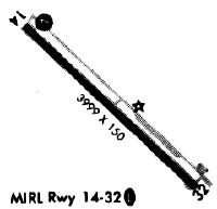
| Runways: | 14/32 |
| Longest Runway: | 14/32 is 4999 ft (1524 m) long |
| Runways with an Instrument Approach: |
KHOE Airport Runway Details
| Runway 14/32 | 4999 ft x 75 ft (1524 m x 23 m) | |
| Runway Length Source: | 3RD PARTY SURVEY as of 05/08/2013 | |
| Surface: | Asphalt - Good condition - No special surface treatment | |
| Runway Edge Lights: | Medium Intensity | |
Runway Weight Bearing Capacity (in thousands of pounds) |
||
| Single Wheel Landing Gear: | 30.0 | |
Runway 14 |
Runway 32 |
|
Elevation: |
186.7 | 182.4 |
Latitude: |
31-03-42.3944N | 31-03-07.1768N |
Longitude: |
082-46-51.1391W | 082-46-10.7754W |
|
Runway True Alignment: |
135 | 315 |
Glide Path Angle: |
3.0 degrees | 3.0 degrees |
Traffic Pattern: |
Left | Left |
Runway Markings Type: |
Nonprecision Instrument | Nonprecision Instrument |
Runway Markings Condition: |
Good | Good |
Object at End: |
TREES | TREES |
Object Height: |
21 | 31 |
Distance from End: |
557 | 448 |
Object Centerline Offset: |
265 ft. right of centerline | 300 ft. left of centerline |
Visual Glide Slope Indicators: |
2-Light PAPI On Left Side Of Runway | 2-Light PAPI On Left Side Of Runway |
Threshold Crossing Height: |
38 | 40 |
Services
Airframe Repair: |
Minor |
Powerplant Repair: |
Minor |
Bottled Oxygen: |
None |
Bulk Oxygen: |
None |
Fuel Available: |
100LL, Jet A+ |
Landing Fees: |
No |
Parking: |
Tiedowns available |
Maps & Diagrams
KHOE Sectional
Flight Planning
at skyvector.com
at skyvector.com