Location
Latitude: |
36-45-57.9990N (36.766111) |
Longitude: |
080-49-24.8160W (-80.82356) |
Elevation: |
2693.6 feet MSL (821 m MSL) |
Magnetic Variation: |
8.2 W (as of April 2024 from WMM2020 model) |
Time Zone: |
UTC -5.0 (Standard Time) UTC -4.0 (Daylight Savings Time) |
From City: |
07 N.M. NE of Galax Hillsville, Virginia |
Found On: |
Cincinnati Chart |
FAA Region: |
AEA |
Contacts
Manager: |
Publicly owned: |
| MICHAEL LAWSON 504 HANGAR RD. HILLSVILLE, VA 24343-5264 276-728-4504 |
TWIN COUNTY ARPT COMSN 504 HANGAR RD. HILLSVILLE, VA 24343-5264 276-728-4504 |
Operations
Airport Status: |
Operational |
Facility Use: |
Public |
Type: |
Airport |
Control tower: |
No |
Attendance (Months/Days/Hours): |
Months/Days/Hours ALL/M-F/0800-1700 |
Boundary ARTCC: |
ZTL (Atlanta) |
Responsible ARTCC: |
ZDC (Washington) |
Lighting Schedule: |
SEE RMK |
Segmented Circle Indicator: |
No |
Traffic Pattern Altitude (MSL): |
3694 feet (1126 m) |
NOTAMs Facility: |
HLX |
NOTAM-D Service: |
Yes |
International Airport of Entry: |
No |
Customs Landing Rights: |
No |
Military Landing Rights: |
Yes |
Civil/Military Joint Use: |
No |
Based Aircraft
| Single Engine: | 17 |
| Multi Engine: | 1 |
| GA Helicopters: | 3 |
Annual Operations (as of 12/31/2022)
| Total Operations: | 8796 | |
| GA Local: | 3744 | 42.6% |
| GA Itinerant: | 4991 | 56.7% |
| Military Aircraft: | 61 | 0.7% |
Communications
| CTAF: | 122.800 |
| Unicom: | 122.800 |
| Approach: | ROANOKE 126.0 126.0 |
| Departure: | ROANOKE 126.0 126.0 |
| AWOS-3: | 118.375 (276-728-5897) |
Fixed Based Operators (FBOs) & Fuel
(Click on a business for detail)
Please help us keep this information up to date. This is a FREE SERVICE just like everything else on Airport Guide! If you see that a business needs to be added, modified, or deleted please fill out our Update Form.
To add, modify, or delete a business click here.
Please help us keep this information up to date. This is a FREE SERVICE just like everything else on Airport Guide! If you see that a business needs to be added, modified, or deleted please fill out our Update Form.
Area Code: 540 |
| Business Name | Frequency | Phone | Fuel Grade |
|---|
Flight Service Stations
| Primary | Alternate | |
| FSS on Field: | N | |
| FSS Name (ID): | Leesburg(DCA) | |
| Frequency: | ||
| Toll Free Phone: | 1-800-WX-BRIEF |
Instrument Procedures / Charts
FAA Terminal Procedures valid from 0901Z 03/21/24 to 0901Z 04/18/24.
There are various types of charts available for an airport. They are listed in the Page Type column. Here is a legend for those types:
APD - Airport Diagram
DP - Departure Procedure Charts
HOT - Hot Spots
IAP - Instrument Approach Procedure Charts
MIN - Minimums
STAR - Standard Terminal Arrival Charts
| Page Type | Page Name | Volume | Action Since Last Cycle |
|---|---|---|---|
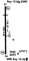
| IAP | RNAV (GPS) RWY 01 | NE-3 | |
| IAP | RNAV (GPS) RWY 19 | NE-3 | |
| MIN | ALTERNATE MINIMUMS | NE-3 | |
| MIN | TAKEOFF MINIMUMS | NE-3 |
Terminal Procedures are only available for airports in several countries with more being added all the time. If you are looking for a specific country's charts, please send an email to support(at)airportguide.com stating the country name. This will be used to prioritize the implementation.
Navigation Aids (Navaids) near KHLX
| Dist (NM) | ID | Morse Code | Name | Type | Freq | True Hdg | Mag Hdg |
|---|---|---|---|---|---|---|---|
| 0.2 | HLX | . . . . . _ . . _ . . _ | Hillsville | NDB | 269 | 161 | 169 |
| 20.0 | PSK | . _ _ . . . . _ . _ | Pulaski | VORTAC | 116.80 | 15 | 23 |
| 22.2 | MKJ | _ _ _ . _ . _ _ _ | Suzze | NDB | 335 | 294 | 302 |
| 26.8 | AZW | . _ _ _ . . . _ _ | Mount Airy | NDB | 223 | 149 | 157 |
| 27.8 | ZEF | _ _ . . . . . _ . | Zephyr | NDB | 326 | 170 | 178 |
| 31.2 | JUH | . _ _ _ . . _ . . . . | Ashee | NDB | 410 | 230 | 238 |
| 33.3 | TEC | _ . _ . _ . | Tech | NDB | 368 | 37 | 45 |
| 37.0 | BLF | _ . . . . _ . . . . _ . | Bluefield | VOR-DME | 115.05 | 331 | 339 |
| 41.4 | UKF | . . _ _ . _ . . _ . | Wilki | NDB | 209 | 198 | 206 |
| 44.9 | UV | . . _ . . . _ | Bales | NDB | 396 | 103 | 111 |
| 50.0 | ROA | . _ . _ _ _ . _ | Roanoke | VOR-DME | 109.40 | 45 | 53 |
| 52.0 | OQA | _ _ _ _ _ . _ . _ | Rockingham County | FAN MARKER | 112 | 121 | |
| 52.2 | VIT | . . . _ . . _ | Vinton | NDB | 277 | 59 | 68 |
| 52.4 | IN | . . _ . | Reeno | NDB | 317 | 142 | 150 |
| 52.5 | ODR | _ _ _ _ . . . _ . | Woodrum | VOR | 114.90 | 50 | 59 |
| 54.1 | VJ | . . . _ . _ _ _ | Whine | NDB | 236 | 268 | 276 |
| 56.1 | SIF | . . . . . . . _ . | Slammer | NDB | 423 | 113 | 122 |
| 57.5 | BZM | _ . . . _ _ . . _ _ | Barretts Mountain | VOR-DME | 113.75 | 200 | 208 |
| 59.5 | GSO | _ _ . . . . _ _ _ | Greensboro | VORTAC | 116.20 | 136 | 144 |
| 60.4 | GZG | _ _ . _ _ . . _ _ . | Glade Spring | VOR-DME | 110.20 | 273 | 281 |
Nearby Airports with Fuel
Notices to Airmen (NOTAMS)
Remarks
| A110-2 | DEER ON & INVOF ARPT. |
| A110-3 | RY 01 10-20 FT HILL LCTD 150 FT WEST OF RY 01 BEGINS NORTH OF THLD. |
| A110-4 | ROA TWR SVCS AVBL AT 540-563-1307. |
| A110-5 | FOR CD CTC ROANOKE APCH AT 540-563-1307. |
| A13 | FAX 276-728-4544. |
| A17 | WEEKEND ATTENDANCE: COORDINATE DURING REGULAR WEEKLY BUS. HRS. |
| A17 1 | AFTER HOURS TERMINAL ACCESS AVAILABLE SOUTH SIDE OF BUILDING. |
| A17 2 | UNATTENDED NEW YEAR'S DAY, EASTER, THANKSGIVING, & CHRISTMAS |
| A42-19 | RY MARKING CONDITIONS VARY BTWN GOOD & FAIR. RY DISPLACEMENT MARKING INCORRECT |
| A52-01 | RY 01 HAS 10-20 FT HILL LCTD 150 FT WEST OF RY 01, BEGINS NORTH OF THLD. |
| A70-FUEL-10 | 0LL SELF-SVC FUEL AVLB 24 HRS WITH CREDIT CARD. |
| A81-APT | ACTVT MIRL RY 1/19 - CTAF. |
Runways
Runway Summary
| Runways: | 01/19 |
| Longest Runway: | 01/19 is 4204 ft (1281 m) long |
| Runways with an Instrument Approach: |
KHLX Airport Runway Details
| Runway 01/19 | 4204 ft x 75 ft (1281 m x 23 m) | |
| Runway Length Source: | 3RD PARTY SURVEY as of 10/02/2018 | |
| Surface: | Asphalt - Fair condition - No special surface treatment | |
| Runway Edge Lights: | Medium Intensity | |
Runway Weight Bearing Capacity (in thousands of pounds) |
||
| Single Wheel Landing Gear: | 12.5 | |
Runway 01 |
Runway 19 |
|
Elevation: |
2693.5 | 2642.0 |
Latitude: |
36-45-37.2232N | 36-46-18.7742N |
Longitude: |
080-49-24.2742W | 080-49-25.3588W |
|
Runway True Alignment: |
359 | 179 |
Glide Path Angle: |
3.0 degrees | 0.0 degrees |
Traffic Pattern: |
Left | Left |
Runway Markings Type: |
Nonprecision Instrument | Nonprecision Instrument |
Runway Markings Condition: |
Good | Good |
Object at End: |
TREES | TREES |
Object Height: |
41 | 54 |
Distance from End: |
985 | 1237 |
Object Centerline Offset: |
355 ft. left of centerline | 63 ft. right of centerline |
Visual Glide Slope Indicators: |
2-Light PAPI On Left Side Of Runway | |
REIL: |
Yes | Yes |
Threshold Crossing Height: |
21 | |
Threshold Elevation: |
2642.4 | |
Displaced Threshold: |
50 | |
Threshold Latitude: |
36-46-18.3000N | |
Threshold Longitude: |
080-49-25.3700W |
Services
Airframe Repair: |
Major |
Powerplant Repair: |
Major |
Bottled Oxygen: |
None |
Bulk Oxygen: |
None |
Fuel Available: |
100LL, Jet A+ |
Landing Fees: |
No |
Parking: |
Hangars and tiedowns available |
Maps & Diagrams
KHLX Sectional
Flight Planning
at skyvector.com
at skyvector.com