Location
Latitude: |
38-36-23.5000N (38.606528) |
Longitude: |
087-43-36.1000W (-87.726694) |
Elevation: |
429.4 feet MSL (131 m MSL) |
Magnetic Variation: |
3.7 W (as of April 2024 from WMM2020 model) |
Time Zone: |
UTC -6.0 (Standard Time) UTC -5.0 (Daylight Savings Time) |
From City: |
12 N.M. N of Mount Carmel, Illinois |
Found On: |
St Louis Chart |
FAA Region: |
AGL |
Contacts
Manager: |
Publicly owned: |
| KEN WOOD 10188 MT CARMEL AIRPORT LN ST FRANCISVILLE, IL 62460 618-948-2413 |
CITY OF MT CARMEL CITY HALL 631 N. MARKET ST MT CARMEL, IL 62863 618-262-4822 |
Operations
Airport Status: |
Operational |
Facility Use: |
Public |
Type: |
Airport |
Activation Date: |
01/1948 |
Control tower: |
No |
Attendance (Months/Days/Hours): |
Months/Days/Hours ALL/ALL/0800-1700 |
Boundary ARTCC: |
ZID (Indianapolis) |
Responsible ARTCC: |
ZID (Indianapolis) |
Lighting Schedule: |
SEE RMK |
Segmented Circle Indicator: |
Yes |
Traffic Pattern Altitude (MSL): |
1429 feet (436 m) |
NOTAMs Facility: |
AJG |
NOTAM-D Service: |
Yes |
International Airport of Entry: |
No |
Customs Landing Rights: |
No |
Military Landing Rights: |
Yes |
Civil/Military Joint Use: |
No |
Based Aircraft
| Single Engine: | 12 |
| Multi Engine: | 1 |
| GA Helicopters: | 1 |
Annual Operations (as of 05/31/2022)
| Total Operations: | 11000 | |
| Air Taxi: | 750 | 6.8% |
| GA Local: | 6500 | 59.1% |
| GA Itinerant: | 3500 | 31.8% |
| Military Aircraft: | 250 | 2.3% |
Communications
| CTAF: | 122.700 |
| Unicom: | 122.700 |
| Approach: | EVANSVILLE 125.6 125.6 INDIANAPOLIS ARTCC |
| Departure: | EVANSVILLE 125.6 125.6 INDIANAPOLIS ARTCC |
| AWOS-3: | 134.900 (618-948-2184) |
- APCH/DEP SVC PRVDD BY INDIANAPOLIS ARTCC ON FREQS 128.3/291.625 (EVANSVILLE RCAG) WHEN EVANSVILLE APCH CTL CLSD.
Fixed Based Operators (FBOs) & Fuel
(Click on a business for detail)
Please help us keep this information up to date. This is a FREE SERVICE just like everything else on Airport Guide! If you see that a business needs to be added, modified, or deleted please fill out our Update Form.
To add, modify, or delete a business click here.
Please help us keep this information up to date. This is a FREE SERVICE just like everything else on Airport Guide! If you see that a business needs to be added, modified, or deleted please fill out our Update Form.
Area Code: 618 |
| Business Name | Frequency | Phone | Fuel Grade |
|---|---|---|---|
| Trainair
Update FBO info |
948-2413 | 100LL |
Flight Service Stations
| Primary | Alternate | |
| FSS on Field: | N | |
| FSS Name (ID): | Saint Louis(STL) | |
| Frequency: | ||
| Toll Free Phone: | 1-800-WX-BRIEF |
Instrument Procedures / Charts
FAA Terminal Procedures valid from 0901Z 03/21/24 to 0901Z 04/18/24.
There are various types of charts available for an airport. They are listed in the Page Type column. Here is a legend for those types:
APD - Airport Diagram
DP - Departure Procedure Charts
HOT - Hot Spots
IAP - Instrument Approach Procedure Charts
MIN - Minimums
STAR - Standard Terminal Arrival Charts
| Page Type | Page Name | Volume | Action Since Last Cycle |
|---|---|---|---|
| IAP | RNAV (GPS) RWY 04 | EC-3 | |
| IAP | RNAV (GPS) RWY 22 | EC-3 | |
| IAP | RNAV (GPS) RWY 31 | EC-3 | |
| MIN | TAKEOFF MINIMUMS | EC-3 |
Terminal Procedures are only available for airports in several countries with more being added all the time. If you are looking for a specific country's charts, please send an email to support(at)airportguide.com stating the country name. This will be used to prioritize the implementation.
Navigation Aids (Navaids) near KAJG
| Dist (NM) | ID | Morse Code | Name | Type | Freq | True Hdg | Mag Hdg |
|---|---|---|---|---|---|---|---|
| 9.5 | OEA | _ _ _ . . _ | Vincennes | NDB | 251 | 57 | 61 |
| 11.4 | LWV | . _ . . . _ _ . . . _ | Lawrenceville | DME | 108.8 | 30 | 34 |
| 18.4 | SAM | . . . . _ _ _ | Samsville | DME | 116.6 | 246 | 250 |
| 21.9 | OLY | _ _ _ . _ . . _ . _ _ | Olney | NDB | 272 | 287 | 291 |
| 24.8 | PLX | . _ _ . . _ . . _ . . _ | Palestine | NDB | 391 | 9 | 13 |
| 24.9 | RSV | . _ . . . . . . . _ | Robinson | VOR-DME | 108.40 | 8 | 12 |
| 33.1 | SIV | . . . . . . . . _ | Sullivan | NDB | 326 | 23 | 27 |
| 34.8 | FWC | . . _ . . _ _ _ . _ . | Wayne County | NDB | 257 | 247 | 250 |
| 35.2 | PDW | . _ _ . _ . . . _ _ | Evansville | NDB | 284 | 164 | 168 |
| 40.0 | BIB | _ . . . . . _ . . . | Bible Grove | VORTAC | 109.00 | 298 | 301 |
| 40.7 | PXV | . _ _ . _ . . _ . . . _ | Pocket City | VORTAC | 113.30 | 182 | 186 |
| 42.0 | HNB | . . . . _ . _ . . . | Huntingburg | VOR-DME | 109.20 | 120 | 124 |
| 43.8 | CZB | _ . _ . _ _ . . _ . . . | Casey | NDB | 359 | 343 | 347 |
| 49.3 | HU | . . . . . . _ | Yinno | NDB | 245 | 18 | 22 |
| 52.8 | VNN | . . . _ _ . _ . | Mount Vernon | DME | 113.8 | 254 | 257 |
| 54.3 | MT | _ _ _ | Zebre | NDB | 347 | 337 | 341 |
| 57.4 | TTH | _ _ . . . . | Terre Haute | VORTAC | 115.30 | 22 | 26 |
| 58.1 | OWB | _ _ _ . _ _ _ . . . | Owensboro | VOR-DME | 108.60 | 152 | 156 |
| 58.2 | SLO | . . . . _ . . _ _ _ | Salem | NDB | 400 | 272 | 275 |
| 58.4 | MTO | _ _ _ _ _ _ | Mattoon | DME | 109.4 | 333 | 337 |
Nearby Airports with Fuel
Notices to Airmen (NOTAMS)
Remarks
| A110-1 | SELF SVC FUEL AVBL H24 WITH CREDIT CARD. |
| A110-2 | FOR CD CTC EVANSVILLE APCH AT 812-436-4690, WHEN APCH CLSD CTC INDIANAPOLIS ARTCC AT 317-247-2411. |
| A15 | EMAIL ADDRESS: AJGAIRPORT@GMAIL.COM (ALL LOWER CASE) |
| A43-04 | PVASI UNUSBL BYD 5 DEG LEFT & RIGHT OF CNTRLN. |
| A43-13 | PVASI UNUSBL BYD 5 DEG LEFT & RIGHT OF CNTRLN. |
| A43-22 | PVASI UNUSBL BYD 5 DEG LEFT & RIGHT OF CNTRLN. |
| A43-31 | PVASI UNUSBL BYD 5 DEG LEFT & RIGHT OF CNTRLN. |
| A81-APT | ACTVT REIL RWY 04, 13, 22 & 31; PVASI RWY 04, 13, 22 & 31; MIRL RWY 13/31- CTAF. MIRL RWY 04/22 PRESET ON LOW INTST TO INCR INTST - CTAF. |
| E111 | EXISTED PRIOR TO 1959. |
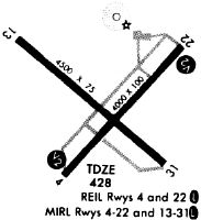
Runways
Runway Summary
| Runways: | 04/22 13/31 |
| Longest Runway: | 13/31 is 4500 ft (1372 m) long |
| Runways with an Instrument Approach: |
KAJG Airport Runway Details
| Runway 04/22 | 4000 ft x 100 ft (1219 m x 30 m) | |
| Runway Length Source: | 3RD PARTY SURVEY as of 06/22/2012 | |
| Surface: | Asphalt - Fair condition - No special surface treatment | |
| Runway Pavement Class: | 16 /F/D/X/T | |
| Runway Edge Lights: | Medium Intensity | |
Runway Weight Bearing Capacity (in thousands of pounds) |
||
| Single Wheel Landing Gear: | 40.5 | |
| Dual Wheel Landing Gear: | 54.0 | |
Runway 04 |
Runway 22 |
|
Elevation: |
428.3 | 428.5 |
Latitude: |
38-36-07.3098N | 38-36-37.2480N |
Longitude: |
087-43-47.6337W | 087-43-14.7466W |
|
Runway True Alignment: |
041 | 221 |
Glide Path Angle: |
3.0 degrees | 3.0 degrees |
Traffic Pattern: |
Left | Left |
Runway Markings Type: |
Nonprecision Instrument | Nonprecision Instrument |
Runway Markings Condition: |
Good | Good |
Visual Glide Slope Indicators: |
Pulsating/Steady Burning VASI On Left Side Of Runway | Pulsating/Steady Burning VASI On Left Side Of Runway |
REIL: |
Yes | Yes |
Touchdown Lights: |
No | No |
Centerline Lights: |
No | No |
Threshold Crossing Height: |
23 | 22 |
| Runway 13/31 | 4500 ft x 75 ft (1372 m x 23 m) | |
| Runway Length Source: | 3RD PARTY SURVEY as of 06/22/2012 | |
| Surface: | Asphalt - Fair condition - No special surface treatment | |
| Runway Pavement Class: | 21 /F/D/X/T | |
| Runway Edge Lights: | Medium Intensity | |
Runway Weight Bearing Capacity (in thousands of pounds) |
||
| Single Wheel Landing Gear: | 54.5 | |
| Dual Wheel Landing Gear: | 71.0 | |
Runway 13 |
Runway 31 |
|
Elevation: |
426.6 | 429.2 |
Latitude: |
38-36-39.1848N | 38-36-10.1588N |
Longitude: |
087-44-01.9962W | 087-43-19.0597W |
|
Runway True Alignment: |
131 | 311 |
Glide Path Angle: |
3.0 degrees | 3.0 degrees |
Runway Markings Type: |
Nonprecision Instrument | Nonprecision Instrument |
Runway Markings Condition: |
Good | Good |
Visual Glide Slope Indicators: |
Pulsating/Steady Burning VASI On Left Side Of Runway | Pulsating/Steady Burning VASI On Left Side Of Runway |
REIL: |
Yes | Yes |
Threshold Crossing Height: |
23 | 25 |
Services
Airframe Repair: |
Major |
Powerplant Repair: |
Major |
Fuel Available: |
100LL |
Landing Fees: |
No |
Parking: |
Hangars and tiedowns available |
Maps & Diagrams
KAJG Sectional
Flight Planning
at skyvector.com
at skyvector.com