Location
Latitude: |
39-43-47.3000N (39.729806) |
Longitude: |
092-27-24.2000W (-92.456722) |
Elevation: |
878.0 feet MSL (268 m MSL) |
Magnetic Variation: |
0.4 W (as of April 2024 from WMM2020 model) |
Time Zone: |
UTC -6.0 (Standard Time) UTC -5.0 (Daylight Savings Time) |
From City: |
01 N.M. SE of Macon, Missouri |
Found On: |
Kansas City Chart |
FAA Region: |
ACE |
Contacts
Manager: |
Publicly owned: |
| DAVE COLEMAN 1001 PATTON ST MACON, MO 63552 660-385-6208 |
CITY OF MACON 106 W. BOURKE, PO BOX 569 MACON, MO 63552 660-385-6421 |
Operations
Airport Status: |
Operational |
Facility Use: |
Public |
Type: |
Airport |
Activation Date: |
09/1947 |
Control tower: |
No |
Attendance (Months/Days/Hours): |
Months/Days/Hours ALL/ALL/0800-1700 |
Boundary ARTCC: |
ZKC (Kansas City) |
Responsible ARTCC: |
ZKC (Kansas City) |
Lighting Schedule: |
SEE RMK |
Segmented Circle Indicator: |
Yes |
Traffic Pattern Altitude (MSL): |
1878 feet (572 m) |
NOTAMs Facility: |
COU |
NOTAM-D Service: |
Yes |
International Airport of Entry: |
No |
Customs Landing Rights: |
No |
Military Landing Rights: |
Yes |
Civil/Military Joint Use: |
No |
Based Aircraft
| Single Engine: | 14 |
Annual Operations (as of 12/31/2021)
| Total Operations: | 5024 | |
| Air Taxi: | 210 | 4.2% |
| GA Local: | 1770 | 35.2% |
| GA Itinerant: | 3024 | 60.2% |
| Military Aircraft: | 20 | 0.4% |
Communications
| CTAF: | 122.800 |
| Unicom: | 122.800 |
- APCH/DEP SVC PRVDD BY KANSAS CITY ARTCC ON FREQS 125.25/235.975(CHILLICOTHE RCAG).
Fixed Based Operators (FBOs) & Fuel
(Click on a business for detail)
Please help us keep this information up to date. This is a FREE SERVICE just like everything else on Airport Guide! If you see that a business needs to be added, modified, or deleted please fill out our Update Form.
To add, modify, or delete a business click here.
Please help us keep this information up to date. This is a FREE SERVICE just like everything else on Airport Guide! If you see that a business needs to be added, modified, or deleted please fill out our Update Form.
Area Code: 660 |
| Business Name | Frequency | Phone | Fuel Grade |
|---|---|---|---|
| Aircraft Service & Improvement
Update FBO info |
385-4998 | ||
| Macon Aviation, L.L.C.
Update FBO info |
Unicom 122.8 | 385-6208 | 100LL |
Flight Service Stations
| Primary | Alternate | |
| FSS on Field: | N | |
| FSS Name (ID): | Columbia(COU) | |
| Frequency: | ||
| Toll Free Phone: | 1-800-WX-BRIEF |
Instrument Procedures / Charts
FAA Terminal Procedures valid from 0901Z 03/21/24 to 0901Z 04/18/24.
There are various types of charts available for an airport. They are listed in the Page Type column. Here is a legend for those types:
APD - Airport Diagram
DP - Departure Procedure Charts
HOT - Hot Spots
IAP - Instrument Approach Procedure Charts
MIN - Minimums
STAR - Standard Terminal Arrival Charts
| Page Type | Page Name | Volume | Action Since Last Cycle |
|---|---|---|---|
| IAP | RNAV (GPS) RWY 02 | NC-3 | |
| IAP | RNAV (GPS) RWY 20 | NC-3 | |
| MIN | TAKEOFF MINIMUMS | NC-3 |
Terminal Procedures are only available for airports in several countries with more being added all the time. If you are looking for a specific country's charts, please send an email to support(at)airportguide.com stating the country name. This will be used to prioritize the implementation.
Navigation Aids (Navaids) near K89
| Dist (NM) | ID | Morse Code | Name | Type | Freq | True Hdg | Mag Hdg |
|---|---|---|---|---|---|---|---|
| 4.7 | MCM | _ _ _ . _ . _ _ | Macon | DME | 112.9 | 194 | 194 |
| 25.1 | IRK | . . . _ . _ . _ | Kirksville | VORTAC | 114.60 | 345 | 345 |
| 30.2 | BZK | _ . . . _ _ . . _ . _ | Brookfield | NDB | 383 | 274 | 274 |
| 40.0 | HLV | . . . . . _ . . . . . _ | Hallsville | VORTAC | 114.20 | 157 | 158 |
| 47.9 | CHT | _ . _ . . . . . _ | Chillicothe | NDB | 375 | 273 | 273 |
| 53.6 | PUR | . _ _ . . . _ . _ . | Marshall | NDB | 371 | 219 | 219 |
| 54.8 | UIN | . . _ . . _ . | Quincy | TACAN | 113.60 | 82 | 83 |
| 56.2 | COU | _ . _ . _ _ _ . . _ | Columbia | VOR-DME | 110.20 | 168 | 168 |
| 56.2 | UI | . . _ . . | Quincy | NDB | 293 | 79 | 80 |
| 56.4 | TRX | _ . _ . _ . . _ | Trenton | NDB | 400 | 292 | 292 |
| 60.9 | BEX | _ . . . . _ . . _ | Bloomfield | NDB | 269 | 1 | 1 |
| 64.4 | EOK | . _ _ _ _ . _ | Keokuk | NDB | 366 | 46 | 47 |
| 65.8 | BQS | _ . . . _ _ . _ . . . | Braymer | VOR-DME | 115.35 | 265 | 265 |
| 69.3 | JEF | . _ _ _ . . . _ . | Jefferson City | VOT | 112.00 | 168 | 168 |
| 70.0 | DMO | _ . . _ _ _ _ _ | Sedalia | NDB | 281 | 208 | 208 |
| 73.1 | JE | . _ _ _ . | Algoa | NDB | 397 | 165 | 166 |
| 78.2 | OTM | _ _ _ _ _ _ | Ottumwa | VOR-DME | 111.60 | 4 | 4 |
| 78.4 | SZL | . . . _ _ . . . _ . . | Whiteman | TACAN | 109.80 | 220 | 220 |
| 79.8 | FFL | . . _ . . . _ . . _ . . | Fairfield | NDB | 332 | 15 | 16 |
| 82.5 | BR | _ . . . . _ . | Burns | NDB | 390 | 47 | 48 |
Nearby Airports with Fuel
Notices to Airmen (NOTAMS)
Remarks
| A110-1 | CROP DUSTING ACFT ON & INVOF ARPT APR-OCT. |
| A110-2 | DEER ON RWY AT EARLY & LATE HRS. |
| A110-3 | FOR SVC AFT HRS CALL 660-385-6208. |
| A110-4 | FOR CD CTC KANSAS CITY ARTCC AT 913-254-8508. |
| A43-20 | UNUSBL BYD 5 DEGS LEFT OF CNTRLN. |
| A57-02 | RWY 2 20:1 BASED ON DSPLCD THR. |
| A70-FUEL-10 | 0LL SELF SVC 100LL AND JET-A FUEL AVBL 24 HRS. |
| A81-APT | ACTVT REIL RWY 02 & 20; PAPI RWY 02 & 20; MIRL RWY 02/20 - CTAF. |
| A96 | ULTRALIGHT ACFT ON & INVOF ARPT. |
Runways
Runway Summary
| Runways: | 02/20 |
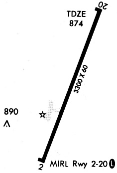
| Longest Runway: | 02/20 is 4150 ft (1265 m) long |
| Runways with an Instrument Approach: |
K89 Airport Runway Details
| Runway 02/20 | 4150 ft x 75 ft (1265 m x 23 m) | |
| Runway Length Source: | 3RD PARTY SURVEY as of 09/27/2013 | |
| Surface: | Concrete - Excellent condition - No special surface treatment | |
| Runway Edge Lights: | Medium Intensity | |
Runway Weight Bearing Capacity (in thousands of pounds) |
||
| Single Wheel Landing Gear: | 12.5 | |
Runway 02 |
Runway 20 |
|
Elevation: |
877.7 | 850.7 |
Latitude: |
39-43-28.0131N | 39-44-06.5958N |
Longitude: |
092-27-33.1726W | 092-27-15.1571W |
|
Runway True Alignment: |
020 | 200 |
Glide Path Angle: |
3.0 degrees | 3.0 degrees |
Traffic Pattern: |
Right | |
Runway Markings Type: |
Nonprecision Instrument | Nonprecision Instrument |
Runway Markings Condition: |
Good | Good |
Object at End: |
ROAD | |
Object Height: |
11 | |
Distance from End: |
400 | |
Object Centerline Offset: |
250 ft. left and right of centerline | |
Visual Glide Slope Indicators: |
4-Light PAPI On Left Side Of Runway | 4-Light PAPI On Left Side Of Runway |
REIL: |
Yes | Yes |
Threshold Crossing Height: |
31 | 41 |
Threshold Elevation: |
876.3 | |
Displaced Threshold: |
596 | |
Threshold Latitude: |
39-43-33.5500N | |
Threshold Longitude: |
092-27-30.5871W |
Services
Bottled Oxygen: |
None |
Bulk Oxygen: |
None |
Fuel Available: |
100LL, Jet A |
Landing Fees: |
No |
Parking: |
Hangars and tiedowns available |
Maps & Diagrams
K89 Sectional
Flight Planning
at skyvector.com
at skyvector.com