Location
Latitude: |
40-05-36.5000N (40.093472) |
Longitude: |
092-32-41.7000W (-92.544917) |
Elevation: |
966.3 feet MSL (295 m MSL) |
Magnetic Variation: |
0.3 W (as of April 2024 from WMM2020 model) |
Time Zone: |
UTC -6.0 (Standard Time) UTC -5.0 (Daylight Savings Time) |
From City: |
06 N.M. SE of Kirksville, Missouri |
Found On: |
Chicago Chart |
FAA Region: |
ACE |
Contacts
Manager: |
Publicly owned: |
| JEFFERY LAFOUNTAIN 27161 DAVID HALL TRAIL KIRKSVILLE, MO 63501 660-665-5020 |
CITY OF KIRKSVILLE CITY HALL, 201 SOUTH FRANKLIN KIRKSVILLE, MO 63501 660-627-1225 |
Operations
Airport Status: |
Operational |
Facility Use: |
Public |
Type: |
Airport |
Activation Date: |
05/1941 |
Control tower: |
No |
Attendance (Months/Days/Hours): |
Months/Days/Hours ALL/ALL/0530-2000 |
Boundary ARTCC: |
ZKC (Kansas City) |
Responsible ARTCC: |
ZKC (Kansas City) |
Lighting Schedule: |
SEE RMK |
Segmented Circle Indicator: |
Yes |
Traffic Pattern Altitude (MSL): |
1966 feet (599 m) |
NOTAMs Facility: |
IRK |
NOTAM-D Service: |
Yes |
International Airport of Entry: |
No |
Customs Landing Rights: |
No |
Military Landing Rights: |
Yes |
Civil/Military Joint Use: |
No |
Aircraft Rescue and Firefighting: |
Class II ARFF Index: A Air Carrier Service: Not Scheduled Certification Date: 05/1973 |
Based Aircraft
| Single Engine: | 16 |
| Jet Engine: | 1 |
Annual Operations (as of 04/30/2023)
| Total Operations: | 5888 | |
| Commercial: | 2190 | 37.2% |
| Air Taxi: | 730 | 12.4% |
| GA Local: | 920 | 15.6% |
| GA Itinerant: | 2000 | 34.0% |
| Military Aircraft: | 48 | 0.8% |
Communications
| CTAF: | 122.800 |
| Unicom: | 122.800 |
| ASOS: | 121.125 (660-627-6059) |
- COMMUNICATIONS PRVDD BY COLUMBIA RADIO ON FREQ 122.2 (KIRKSVILLE RCO).
- APCH/DEP SVC PRVDD BY KANSAS CITY ARTCC ON FREQS 132.6/370.9 (KIRKSVILLE RCAG).
Fixed Based Operators (FBOs) & Fuel
(Click on a business for detail)
Please help us keep this information up to date. This is a FREE SERVICE just like everything else on Airport Guide! If you see that a business needs to be added, modified, or deleted please fill out our Update Form.
To add, modify, or delete a business click here.
Please help us keep this information up to date. This is a FREE SERVICE just like everything else on Airport Guide! If you see that a business needs to be added, modified, or deleted please fill out our Update Form.
Area Code: 660 |
| Business Name | Frequency | Phone | Fuel Grade |
|---|---|---|---|
| Redwing Airways, Inc.
Update FBO info |
Unicom 122.8 | 665-6607 | 100LL, Jet A |
Flight Service Stations
| Primary | Alternate | |
| FSS on Field: | N | |
| FSS Name (ID): | Columbia(COU) | |
| Frequency: | ||
| Toll Free Phone: | 1-800-WX-BRIEF |
Instrument Procedures / Charts
FAA Terminal Procedures valid from 0901Z 03/21/24 to 0901Z 04/18/24.
There are various types of charts available for an airport. They are listed in the Page Type column. Here is a legend for those types:
APD - Airport Diagram
DP - Departure Procedure Charts
HOT - Hot Spots
IAP - Instrument Approach Procedure Charts
MIN - Minimums
STAR - Standard Terminal Arrival Charts
| Page Type | Page Name | Volume | Action Since Last Cycle |
|---|---|---|---|
| APD | AIRPORT DIAGRAM | NC-3 | |
| HOT | HOT SPOT | NC-3 | |
| IAP | ILS OR LOC RWY 36 | NC-3 | |
| IAP | RNAV (GPS) RWY 18 | NC-3 | |
| IAP | RNAV (GPS) RWY 36 | NC-3 | |
| IAP | VOR-A | NC-3 | |
| MIN | ALTERNATE MINIMUMS | NC-3 | |
| MIN | TAKEOFF MINIMUMS | NC-3 |
Terminal Procedures are only available for airports in several countries with more being added all the time. If you are looking for a specific country's charts, please send an email to support(at)airportguide.com stating the country name. This will be used to prioritize the implementation.
Navigation Aids (Navaids) near IRK
| Dist (NM) | ID | Morse Code | Name | Type | Freq | True Hdg | Mag Hdg |
|---|---|---|---|---|---|---|---|
| 3.3 | IRK | . . . _ . _ . _ | Kirksville | VORTAC | 114.60 | 319 | 319 |
| 26.5 | MCM | _ _ _ . _ . _ _ | Macon | DME | 112.9 | 173 | 173 |
| 32.6 | BZK | _ . . . _ _ . . _ . _ | Brookfield | NDB | 383 | 232 | 232 |
| 39.4 | BEX | _ . . . . _ . . _ | Bloomfield | NDB | 269 | 7 | 7 |
| 47.6 | CHT | _ . _ . . . . . _ | Chillicothe | NDB | 375 | 246 | 246 |
| 48.1 | TRX | _ . _ . _ . . _ | Trenton | NDB | 400 | 269 | 269 |
| 55.5 | EOK | . _ _ _ _ . _ | Keokuk | NDB | 366 | 65 | 66 |
| 57.0 | OTM | _ _ _ _ _ _ | Ottumwa | VOR-DME | 111.60 | 10 | 10 |
| 60.0 | UIN | . . _ . . _ . | Quincy | TACAN | 113.60 | 103 | 104 |
| 60.6 | FFL | . . _ . . . _ . . _ . . | Fairfield | NDB | 332 | 24 | 25 |
| 60.6 | UI | . . _ . . | Quincy | NDB | 293 | 101 | 102 |
| 61.9 | HLV | . . . . . _ . . . . . _ | Hallsville | VORTAC | 114.20 | 161 | 161 |
| 67.3 | BQS | _ . . . _ _ . _ . . . | Braymer | VOR-DME | 115.35 | 246 | 246 |
| 68.0 | OOA | _ _ _ _ _ _ . _ | Oskaloosa | NDB | 414 | 2 | 2 |
| 69.6 | MPZ | _ _ . _ _ . _ _ . . | Mount Pleasant | NDB | 212 | 42 | 43 |
| 69.9 | PUR | . _ _ . . . _ . _ . | Marshall | NDB | 371 | 205 | 205 |
| 71.7 | LMN | . _ . . _ _ _ . | Lamoni | VOR-DME | 116.70 | 295 | 295 |
| 73.2 | BR | _ . . . . _ . | Burns | NDB | 390 | 62 | 63 |
| 78.4 | COU | _ . _ . _ _ _ . . _ | Columbia | VOR-DME | 110.20 | 168 | 168 |
| 80.7 | PEA | . _ _ . . . _ | Pella | NDB | 257 | 347 | 347 |
Nearby Airports with Fuel
Notices to Airmen (NOTAMS)
Remarks
| A110-1 | FOR CD IF UNA TO CTC ON FSS FREQ, CTC KANSAS CITY ARTCC AT 913-254-8508. |
| A14 | AIRPORT DIRECTOR |
| A26 | RWY 9/27 NOT AVBL FOR SCHEDULED ACR OPNS WITH MORE THAN 9 PSGR SEATS OR UNSCHEDULED ACR AT LEAST 31 PSGR SEATS |
| A42-09 | 09/27 MARKED WITH YELLOW CONES. |
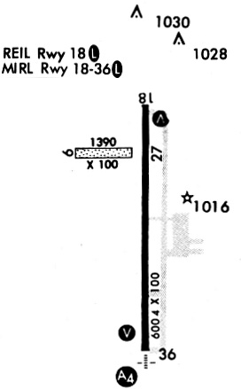
| A81-APT | ACTVT HIRL RY 18/36; VASI RYS 18 & 36; REIL RY 18 & MALSR RY 36 - CTAF. |
Runways
Runway Summary
| Runways: | 09/27 18/36 |
| Longest Runway: | 18/36 is 6005 ft (1830 m) long |
| Runways with an Instrument Approach: | 36 |
IRK Airport Runway Details
| Runway 09/27 | 1370 ft x 100 ft (418 m x 30 m) | |
| Runway Length Source: | 3RD PARTY SURVEY as of 10/29/2011 | |
| Surface: | Turf - Good condition - No special surface treatment | |
Runway 09 |
Runway 27 |
|
Elevation: |
959.0 | 964.2 |
Latitude: |
40-05-52.0959N | 40-05-51.9307N |
Longitude: |
092-33-00.2912W | 092-32-42.6643W |
|
Runway True Alignment: |
091 | 271 |
Glide Path Angle: |
0.0 degrees | 0.0 degrees |
Traffic Pattern: |
Left | Left |
Object at End: |
TREES | TREES |
Object Height: |
72 | 47 |
Distance from End: |
1440 | 1240 |
Object Centerline Offset: |
0 ft. left and right of centerline | 0 ft. left and right of centerline |
| Runway 18/36 | 6005 ft x 100 ft (1830 m x 30 m) | |
| Runway Length Source: | 3RD PARTY SURVEY as of 10/29/2011 | |
| Surface: | Turf - Good condition - No special surface treatment | |
| Runway Pavement Class: | 10 /R/D/W/T | |
| Runway Edge Lights: | High Intensity | |
Runway Weight Bearing Capacity (in thousands of pounds) |
||
| Single Wheel Landing Gear: | 30.0 | |
| Dual Wheel Landing Gear: | 48.0 | |
| Dual Tandem Wheel Landing Gear: | 85.0 | |
Runway 18 |
Runway 36 |
|
Elevation: |
966.2 | 963.7 |
Latitude: |
40-06-02.6369N | 40-05-03.3033N |
Longitude: |
092-32-39.1217W | 092-32-39.7783W |
|
Runway True Alignment: |
180 | 000 |
ILS Type: |
ILS/DME | |
Glide Path Angle: |
3.0 degrees | 3.0 degrees |
Traffic Pattern: |
Left | Left |
Runway Markings Type: |
Nonprecision Instrument | Precision Instrument |
Runway Markings Condition: |
Fair | Fair |
Object Centerline Offset: |
0 ft. left and right of centerline | 0 ft. left and right of centerline |
Visual Glide Slope Indicators: |
4-Box VASI On Left Side Of Runway | 4-Box VASI On Left Side Of Runway |
Approach Light System: |
1,400 Foot Medium Intensity Approach Lighting System With Runway Alignment Indicator Lights | |
REIL: |
Yes | |
Threshold Crossing Height: |
33 | 55 |
Declared Distances |
||
Take Off Run Avbl. (TORA): |
6005 | 6005 |
Take Off Distance Avbl. (TODA): |
6005 | 6005 |
Actual Stop Dist. Avbl. (ASDA): |
6005 | 6005 |
Landing Dist. Avbl. (LDA): |
6005 | 6005 |
Services
Bottled Oxygen: |
None |
Bulk Oxygen: |
None |
Fuel Available: |
100LL |
Landing Fees: |
No |
Parking: |
Tiedowns available |
Maps & Diagrams
IRK Sectional
Flight Planning
at skyvector.com
at skyvector.com